


ESA Observing the Earth 
zdroje zpráv:
Guiding Aeolus' safe reentry
10.7.2023 15:00
After exceeding its planned life in orbit, ESA’s Aeolus wind satellite is on its way back to Earth. The satellite is currently falling around 1 km a day, and its descent is accelerating. ESA’s spacecraft operators will soon intervene and attempt to guide Aeolus in a first-of-its-kind assisted reentry. Why is ESA doing this?
Earth from Space: Cyclone Mocha
7.7.2023 10:00 Image:
The Copernicus Sentinel-3 mission captured this image of the powerful Cyclone Mocha on 13 May 2023 as it made its way across the Bay of Bengal heading northeast towards Bangladesh and Myanmar.
Image:
The Copernicus Sentinel-3 mission captured this image of the powerful Cyclone Mocha on 13 May 2023 as it made its way across the Bay of Bengal heading northeast towards Bangladesh and Myanmar.
First data from Europe’s Lightning Imager
3.7.2023 15:00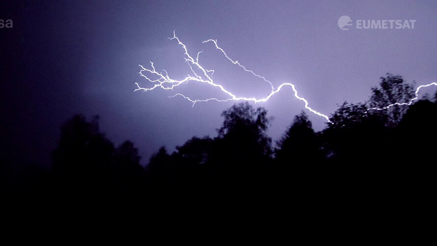 Video:
00:04:49
Video:
00:04:49
Discover the first results from Europe’s first Lightning Imager onboard the Meteosat Third Generation. The Lightning Imager can continuously detect rapid flashes of lighting in Earth’s atmosphere whether day or night from a distance of 36 000 km.
This is the first time a geostationary weather satellite has the capability to detect lightning across Europe, Africa and the surrounding waters. Each camera can capture up to 1000 images per second and will continuously observe lightning activity from space. The data will give weather forecasters greater confidence in their predictions of severe storms.
European satellite strikes lightning
3.7.2023 13:50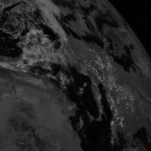
The first ever satellite instrument capable of continuously detecting lightning across Europe and Africa has now been switched on. New animations from the innovative ‘Lighting Imager’ confirm the instrument will revolutionise the detection and prediction of severe storms.
Watch live: First data from Europe’s first lightning detector
3.7.2023 11:40Watch live: First data from Europe’s first Lightning Imager
Tune in at 14:00 CEST for the first results from MTG’s lightning detector
Space to empower rural food producers
30.6.2023 11:00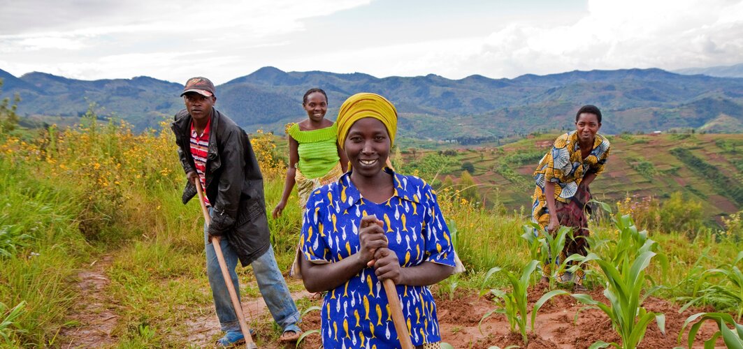
ESA has strengthened their partnership with the UN International Fund for Agricultural Development (IFAD) to help vulnerable small-scale food producers not only increase their ability to grow food but adapt to climate change by using state-of-the-art Earth observation data.
Earth from Space: Southwest Netherlands
30.6.2023 10:00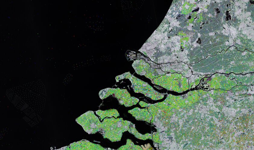 Image:
Rotterdam and part of the Zeeland province in southwest Netherlands are featured in this radar image acquired by Copernicus Sentinel-1.
Image:
Rotterdam and part of the Zeeland province in southwest Netherlands are featured in this radar image acquired by Copernicus Sentinel-1.
Earth from Space: Tashkent, Uzbekistan
23.6.2023 10:00 Image:
The Copernicus Sentinel-2 mission takes us over Tashkent, the capital city of Uzbekistan.
Image:
The Copernicus Sentinel-2 mission takes us over Tashkent, the capital city of Uzbekistan.
Paris Air Show Live – Session on understanding Earth’s water and carbon cycles from space
22.6.2023 13:30 Video:
01:08:04
Video:
01:08:04
By using concrete examples of the water and carbon cycles, the speakers in this session focus on the grand science questions and how we can turn them into answers and solutions most useful to decision-makers at the front line of the climate crisis. Earth is a highly dynamic system where the transport and exchanges of energy and matter are influenced by a multitude of processes and feedback mechanisms. Untangling these complex processes to better understand how Earth works as a system is a major challenge; a challenge that satellites, with their global view, are ideally positioned to tackle. While each mission gives us unique insights, it is by combining their data that makes scientific findings shine the brightest. This, in turn, puts European and international collaboration at the heart of Earth observation today.
Paris Air Show live - From Earth science to climate action
21.6.2023 14:15Paris Air Show live: From Earth science to climate action
22 June at 12:00 CEST: Earth's water and carbon cycles from space
UK suffers marine heatwave
20.6.2023 15:44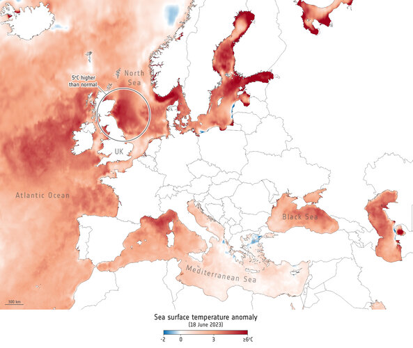 Image:
Some of the most severe marine heat increases on Earth are occurring in the seas surrounding the UK and Ireland. Satellite measurements show that water temperatures in certain areas are above average for this time of year.
Image:
Some of the most severe marine heat increases on Earth are occurring in the seas surrounding the UK and Ireland. Satellite measurements show that water temperatures in certain areas are above average for this time of year.
New Space companies join Copernicus
19.6.2023 15:00
With commercial companies playing an increasingly important role in creating a dynamic and innovative space industry, nine New Space satellite data suppliers have joined the Copernicus programme as ‘Contributing Missions’. Today, at the Le Bourget Paris Air Show, ESA and the European Commission further embraced the era of New Space by welcoming these nine companies into the fold and celebrating the contribution they will make in monitoring our changing world.
Earth from Space: Eastern Mediterranean
16.6.2023 10:00 Image:
Copernicus Sentinel-3’s wide view captures the eastern edge of the Mediterranean and surrounding countries.
Image:
Copernicus Sentinel-3’s wide view captures the eastern edge of the Mediterranean and surrounding countries.
Carbon monoxide from fires in Canada
15.6.2023 14:37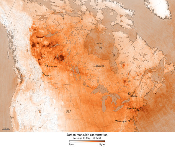 Image:
As climate change increases the risk of wildfires across the globe, the spate of fires that hit Canada in May and June suggest that 2023 is on course to be the country’s worst fire season to date. These fires not only pose a serious threat to human life, wildlife, the environment and property, they also affect air quality.
Image:
As climate change increases the risk of wildfires across the globe, the spate of fires that hit Canada in May and June suggest that 2023 is on course to be the country’s worst fire season to date. These fires not only pose a serious threat to human life, wildlife, the environment and property, they also affect air quality.
Forecasting fires with SMOS
14.6.2023 14:01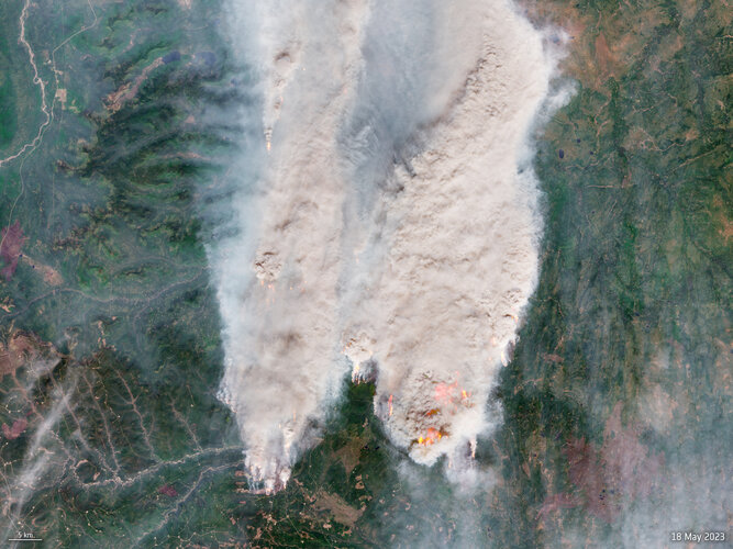
As the current wildfires in Canada show, climate change is increasing the risk and extent of wildfires across the globe. ESA, along with the European Centre for Medium-Range Weather Forecasts have taken a new approach by using realtime observations from ESA’s Soil Moisture and Ocean Salinity satellite mission to better anticipate the outbreak of fires.
Earth from Space: Cook Strait, New Zealand
9.6.2023 10:00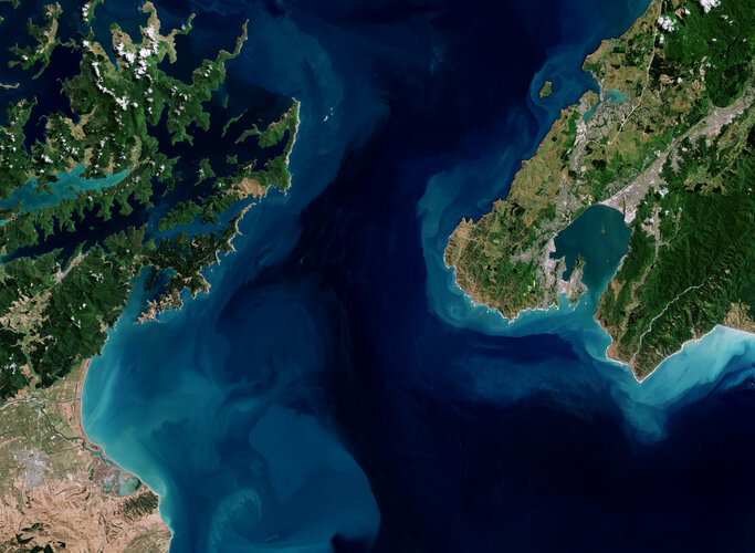 Image:
The Copernicus Sentinel-2 mission takes us over Cook Strait, which separates New Zealand's North and South Islands.
Image:
The Copernicus Sentinel-2 mission takes us over Cook Strait, which separates New Zealand's North and South Islands.
25 years of Copernicus
9.6.2023 9:00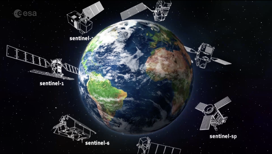 Video:
00:05:05
Video:
00:05:05
25 years ago, Copernicus set out to transform the way we see our planet. It is the largest environmental monitoring programme in the world. Learn more about the Copernicus programme and the Sentinel satellite missions developed by ESA.
25 years of Copernicus
8.6.2023 9:00
Video:
00:05:05
25 years ago, Copernicus set out to transform the way we see our planet. It is the largest environmental monitoring programme in the world. Learn more about the Copernicus programme and the Sentinel satellite missions developed by ESA.
25 times Copernicus made the headlines
7.6.2023 15:55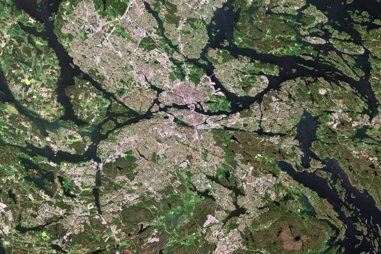
Twenty-five years ago, Copernicus set out to transform the way we see our planet. Now, well established as the largest environmental monitoring programme in the world, it returns a whopping 16 terabytes of high-quality data every single day. To mark a quarter-century of European success in space, we look back at a selection of 25 Copernicus highlights.
Earth from Space: Anchorage, Alaska
2.6.2023 10:00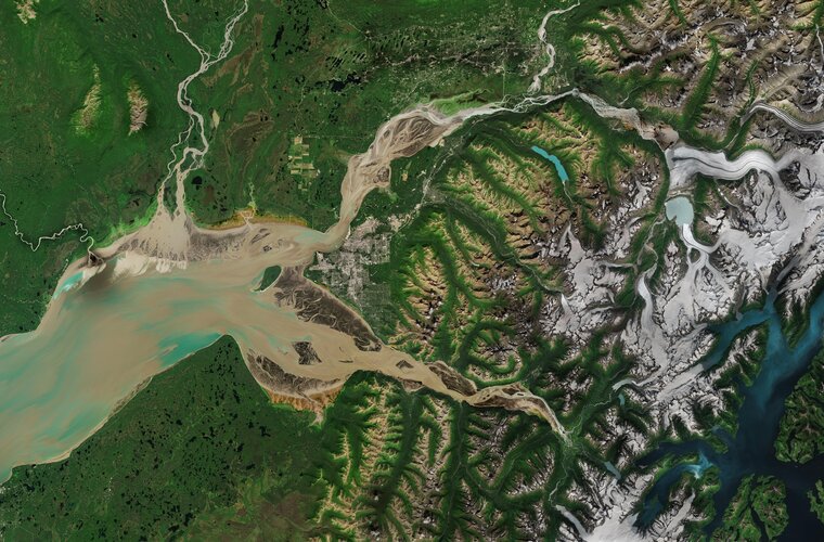 Image:
From the Chugach Mountains on the right to the Cook Inlet on the left, this Copernicus Sentinel-2 image features the varied landscape surrounding Anchorage, the largest and most populous city in the state of Alaska in the United States.
Image:
From the Chugach Mountains on the right to the Cook Inlet on the left, this Copernicus Sentinel-2 image features the varied landscape surrounding Anchorage, the largest and most populous city in the state of Alaska in the United States.
CubeMAP mission development halted
1.6.2023 14:00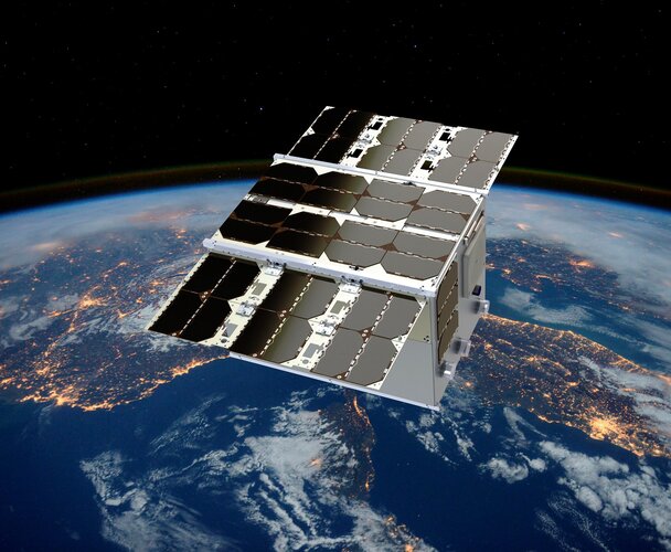
After very careful consideration, ESA’s Earth Observation Programme Board has taken the decision to terminate the development of CubeMAP as a Scout satellite mission. This decision is based on the development path exceeding the programmatic constraints related to the timeline and budgetary boundaries allocated for this category of New Space mission.
Accelerating the Green Transition
1.6.2023 10:30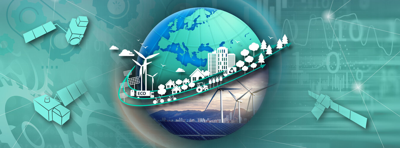
Earth observation has been essential in identifying and monitoring climate change. Satellite data form the baseline for effective European mitigation and adaptation strategies to support the Green Transition, the European Union to reach its goal of becoming carbon neutral by 2050, as well as its Green Deal.
ESA has now concluded its initial phase of a pilot initiative in Austria that demonstrates the untapped potential of space technologies by providing actionable Earth observation information to accelerate the Green Transition for both society and the economy.
Accelerating the Green Transition
1.6.2023 10:30
Earth observation has been essential in identifying and monitoring climate change. Satellite data form the baseline for effective European mitigation and adaptation strategies to support the Green Transition, the European Union's Green Deal and the global goal of becoming carbon neutral by 2050.
ESA has now concluded its initial phase of a pilot initiative in Austria that demonstrates the untapped potential of space technologies by providing actionable Earth observation information to accelerate the Green Transition for both society and the economy.
Register for ESA’s first Earth observation commercialisation event
31.5.2023 8:55
Registration is now open for ESA’s first-ever Earth Observation Commercialisation Forum. Taking place at ESA Headquarters in Paris from 30 to 31 October 2023, investors, institutions, entrepreneurs and companies of any size from the Earth observation sector will now be able to come together and discuss the commercial potential and challenges of Earth observation, together with the technical, industrial and risk-capital support available to European companies.
Aeolus enhances volcanic ash forecasts for aviation safety
30.5.2023 8:55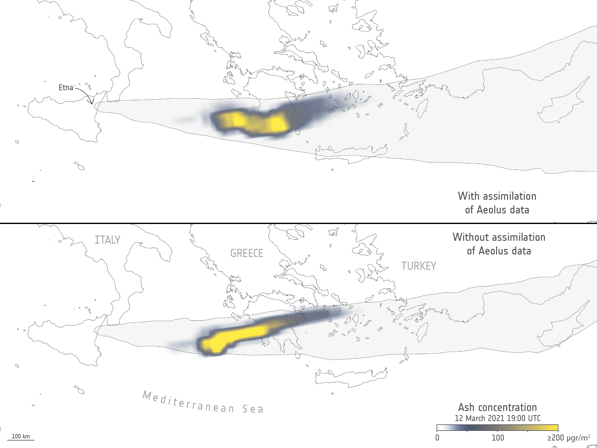
Aeolus enhances volcanic ash forecasts for aviation safety
Earth from Space: São Paulo, Brazil
26.5.2023 10:00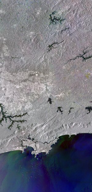 Image:
This radar image from Copernicus Sentinel-1 shows the city of São Paulo and part of the homonymous state in southeast Brazil.
Image:
This radar image from Copernicus Sentinel-1 shows the city of São Paulo and part of the homonymous state in southeast Brazil.
An improved view of global sea ice
25.5.2023 8:55
Earth’s declining ice is without a doubt one of the clearest signs of climate change. A new high-resolution sea-ice concentration data record has just been released as part of ESA’s Climate Change Initiative – providing new insights of sea ice concentration across the globe.
Fighting wildfires in France | FIRE Preview
24.5.2023 16:00 Video:
00:12:42
Video:
00:12:42
Enjoy a sneak peek of ESA’s new documentary that looks at fire in all its fury - and how satellite technology is helping to mitigate this consequence of climate change. Join us on this journey as we meet the firefighter who fought one of the largest wildfires in his career, climate scientists working with satellite data, and the people on the frontline using these data to aid those affected. The full documentary will be released this summer.
Fighting wildfires in France from space | FIRE Preview
24.5.2023 16:00 Video:
00:12:42
Video:
00:12:42
Enjoy a sneak peek of ESA’s new documentary that looks at fire in all its fury - and how satellite technology is helping to mitigate this consequence of climate change. Join us on this journey as we meet the firefighter who fought one of the largest wildfires in his career, climate scientists working with satellite data, and the people on the frontline using these data to aid those affected. The full documentary will be released this summer.
Fighting wildfires in France | FIRE Preview
24.5.2023 16:00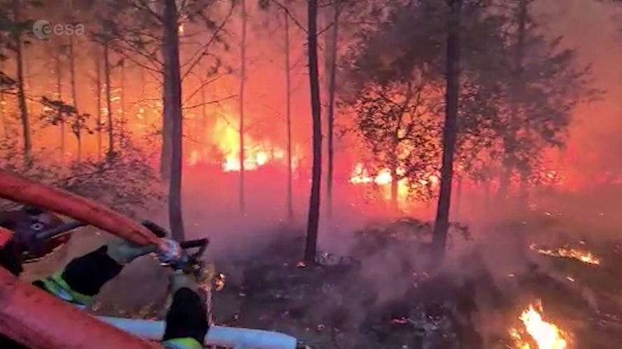 Video:
00:12:42
Video:
00:12:42
Enjoy a sneak peek of ESA’s new documentary that looks at fire in all its fury - and how satellite technology is helping to mitigate this consequence of climate change. Join us on this journey as we meet the firefighter who fought one of the largest wildfires in his career, climate scientists working with satellite data, and the people on the frontline using these data to aid those affected. The full documentary will be released this summer.
Fighting wildfires in France | FIRE Preview
24.5.2023 16:00
Video:
00:12:42
Enjoy a sneak peek of ESA’s new documentary that looks at fire in all its fury - and how satellite technology is helping to mitigate this consequence of climate change. Join us on this journey as we meet the firefighter who fought one of the largest wildfires in his career, climate scientists working with satellite data, and the people on the frontline using these data to aid those affected. The full documentary will be released this summer.
Satellites provide crucial insights into Arctic amplification
24.5.2023 9:45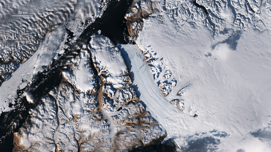
The Arctic, once again at the forefront of climate change, is experiencing disproportionately higher temperature increases compared to the rest of the planet, triggering a series of cascading effects known as Arctic amplification. As concerns continue to grow, satellites developed by ESA have become indispensable tools in understanding and addressing the complex dynamics at play and the far-reaching consequences for the environment and human societies.
Satellites provide crucial insights into Arctic amplification
24.5.2023 9:45
The Arctic, once again at the forefront of climate change, is experiencing disproportionately higher temperature increases compared to the rest of the planet, triggering a series of cascading effects known as Arctic amplification.
As concerns continue to grow, satellites developed by ESA have become indispensable tools in understanding and addressing the complex dynamics at play and the far-reaching consequences for the environment and human societies.
ESA receives Space for Climate Protection Award
23.5.2023 12:20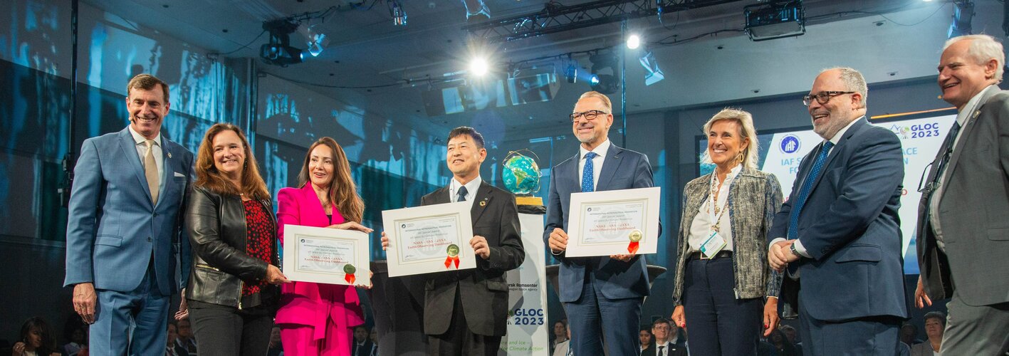
ESA has been presented the ‘Space for Climate Protection’ Special Award by the International Astronautical Federation during the Global Space Conference on Climate Change – currently taking place in Oslo, Norway.
Annual global ice loss simulated over Oslo
23.5.2023 9:00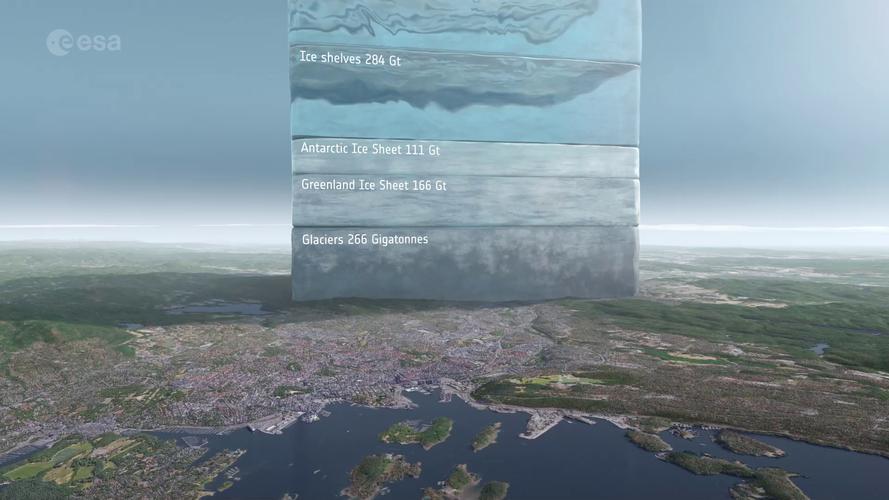 Video:
00:01:20
Video:
00:01:20
Satellites play a vital role in monitoring the rapid changes taking place in the Arctic. Tracking ice lost from the world’s glaciers, ice sheets and frozen land shows that Earth is losing ice at an accelerating rate.
Using information from ESA’s ERS, Envisat and CryoSat satellites as well as the Copernicus Sentinel-1 and Sentinel-2 missions, research led by Tom Slater of the University of Leeds, found that the rate at which Earth has lost ice has increased markedly within the past three decades. Currently, more than a trillion tonnes of ice is lost each year.
To put this into perspective, this is equivalent to an ice cube measuring 10x10x10 km over Oslo’s skyline. Putting it another way, the amount of ice loss globally is equivalent to 12 000 times the annual water use of the Norwegian capital.
The sooner Earth’s temperature is stabilised, the more manageable the impacts of ice loss will be.
Continuity in satellite data is the key to predicting future ice losses, and to assist in mitigating the threats posed by sea-level rise, shrinking high mountain glaciers and further climate feedbacks. The Copernicus Expansion missions, CRISTAL, CIMR and ROSE-L have been designed to fill the gaps in current Sentinel capabilities for comprehensive monitoring of changes in the global ice cover.
Watch now: Global Space Conference on Climate Change
23.5.2023 8:53
Watch now: Global Space Conference on Climate Change

Earth from Space: Oslo, Norway
19.5.2023 10:00 Image:
The Copernicus Sentinel-2 mission takes us over Oslo, Norway’s capital and largest city, and host of the 2023 Global Space Conference on Climate Change, taking place on 23–25 May.
Image:
The Copernicus Sentinel-2 mission takes us over Oslo, Norway’s capital and largest city, and host of the 2023 Global Space Conference on Climate Change, taking place on 23–25 May.
Our oceans are in hot water
17.5.2023 16:30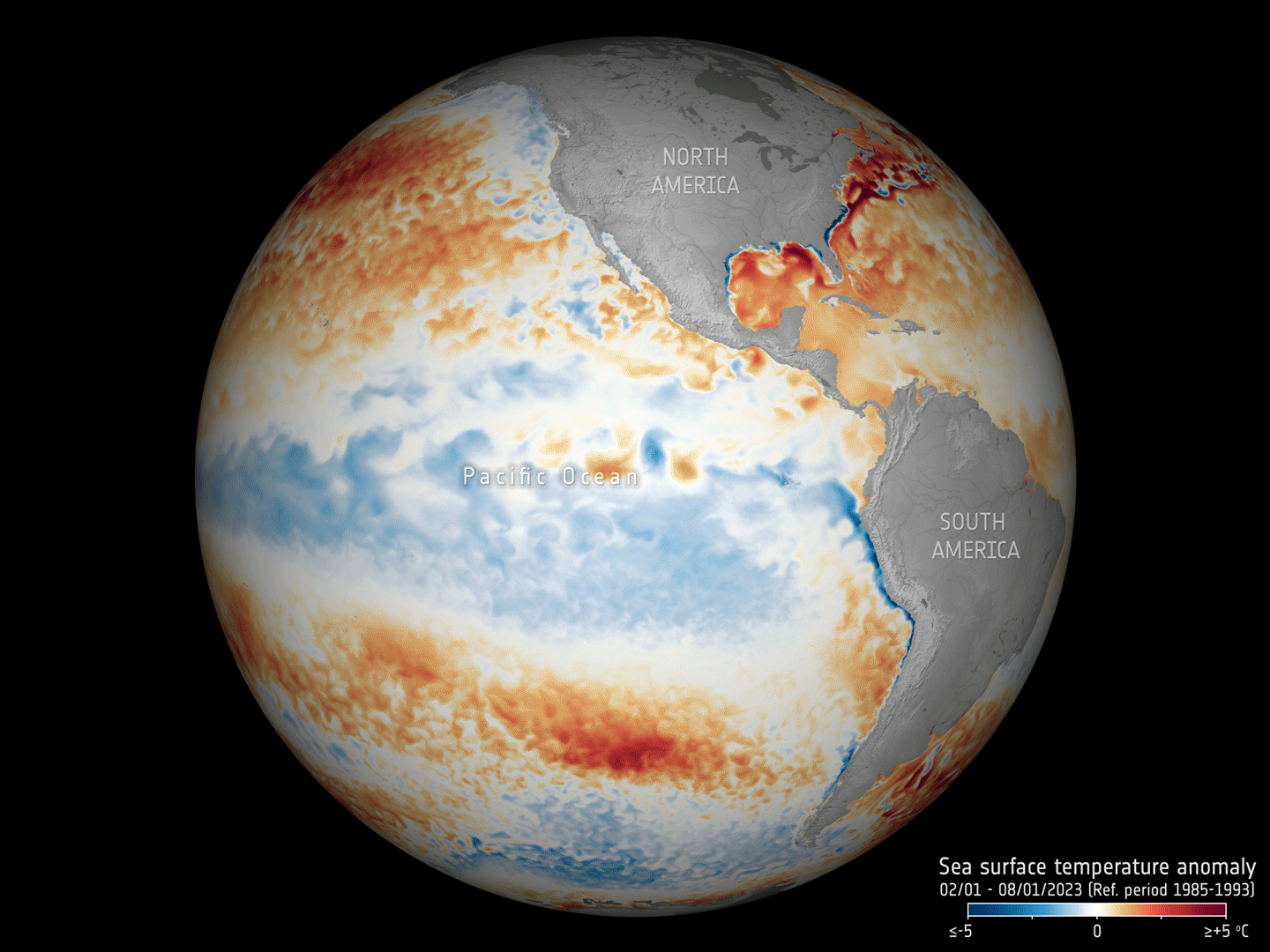
Adding to the grim list of record ice losses, record air temperatures and record droughts, which have all hit the headlines recently, the temperature of the surface waters of our oceans is also at an all-time high. With an El Niño looming, concerns are that we will soon be facing even worse extremes. Satellites orbiting overhead are being used to carefully track the patterns that lead up to El Niño to further understand and predict the consequences of this cyclic phenomenon against the backdrop of climate change.
Our oceans are in hot water
17.5.2023 16:30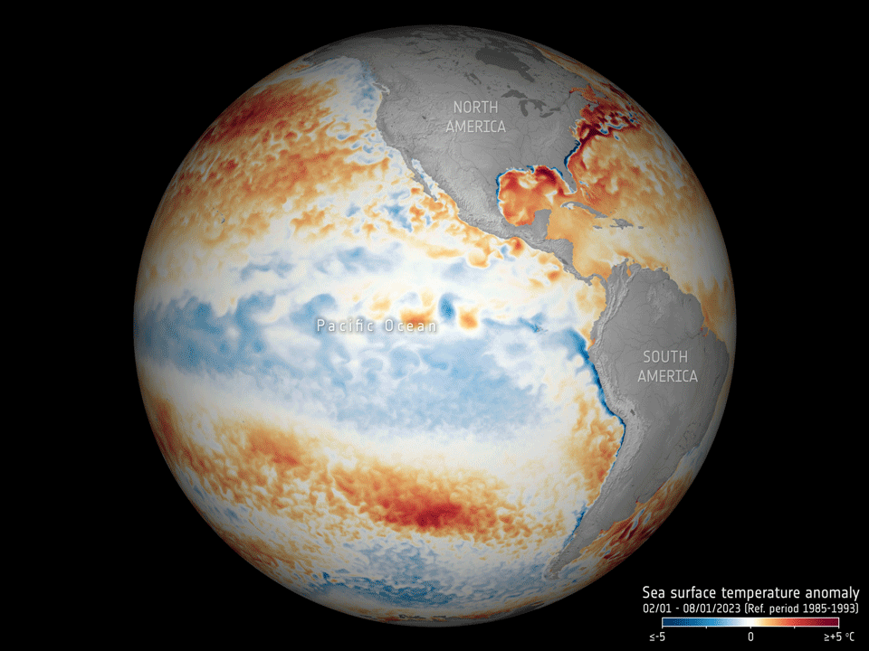
Adding to the grim list of record ice losses, record air temperatures and record droughts, which have all hit the headlines recently, the temperature of the surface waters of our oceans is also at an all-time high. With an El Niño looming, concerns are that we will soon be facing even worse extremes. Satellites orbiting overhead are being used to carefully track the patterns that lead up to El Niño to further understand and predict the consequences of this cyclic phenomenon against the backdrop of climate change.
Earth from Space: Nishinoshima island, Japan
12.5.2023 10:00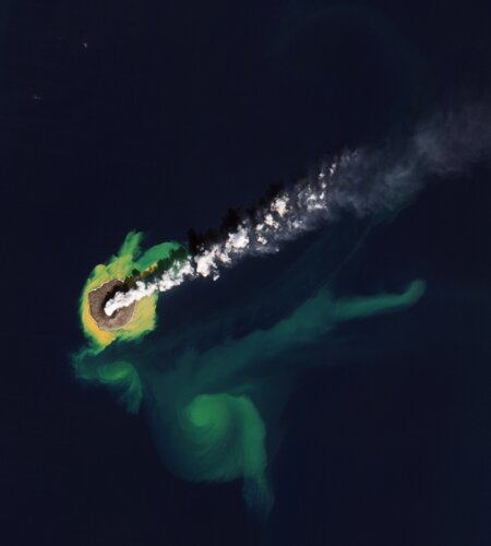 Image:
This Copernicus Sentinel-2 image features the Japanese island of Nishinoshima, in the northwest Pacific Ocean.
Image:
This Copernicus Sentinel-2 image features the Japanese island of Nishinoshima, in the northwest Pacific Ocean.
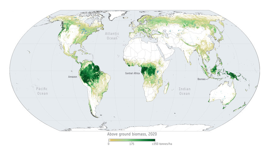
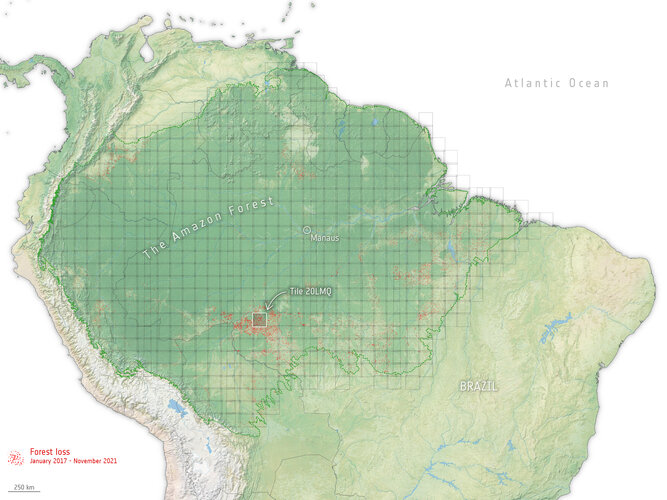
Monitoring fluctuating forest carbon from space
11.5.2023 12:31
Monitoring fluctuating forest carbon from space
Aeolus’ fiery demise to set standard for safe reentry
8.5.2023 13:08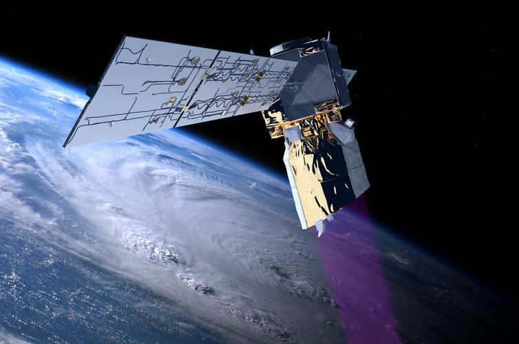
ESA’s wind mission, Aeolus, will soon be lowered in orbit leading to its fiery reentry and burn-up through Earth’s atmosphere. ESA’s efforts to ensure a safe return go well beyond international standards and place the Agency in the lead for space safety.
Earth from Space: Farming the desert
5.5.2023 10:00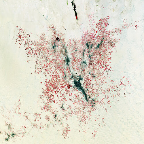 Image:
The Copernicus Sentinel-2 mission takes us over El Oued, in northeast Algeria, about 80 km west of the border with Tunisia.
Image:
The Copernicus Sentinel-2 mission takes us over El Oued, in northeast Algeria, about 80 km west of the border with Tunisia.
Meteosat Third Generation's first stunning image
4.5.2023 14:00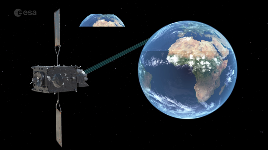 Video:
00:03:57
Video:
00:03:57
Europe’s latest weather satellite, the Meteosat Third Generation Imager, has just delivered its first image of Earth. What does this satellite do exactly? And what does this mean for weather forecasting? Learn more about the Meteosat Third Generation and how this new generation of satellites is set to revolutionise weather forecasting in Europe.
The Meteosat Third Generation image can be downloaded here.
New weather satellite reveals spectacular images of Earth
4.5.2023 10:00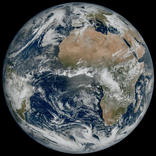
Europe’s latest weather satellite, the Meteosat Third Generation Imager, has just delivered its first view of Earth – revealing conditions over Europe, Africa and the Atlantic in remarkable detail.
Earth from Space: Blooming California
28.4.2023 10:00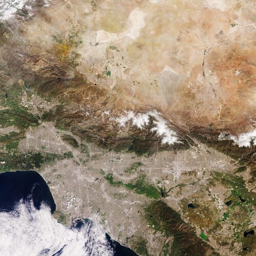 Image:
Captured by the Copernicus Sentinel-2 mission on 8 April 2023, this image shows Los Angeles and part of the hinterland in Southern California.
Image:
Captured by the Copernicus Sentinel-2 mission on 8 April 2023, this image shows Los Angeles and part of the hinterland in Southern California.
CryoSat reveals ice loss from glaciers
26.4.2023 15:00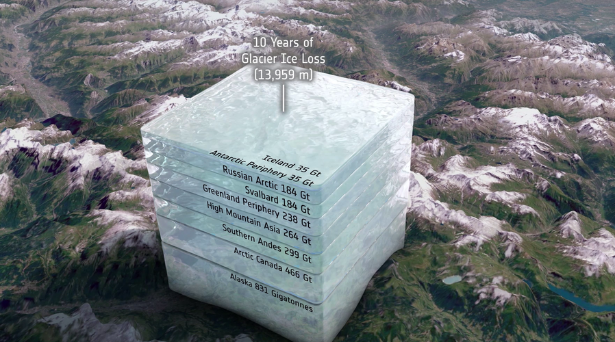
When one thinks of the damage that climate change is doing, it’s probable that what comes to mind is a vision of huge lumps of ice dropping off one of the polar ice sheets and crashing into the ocean. While Greenland and Antarctica are losing masses of ice, so too are most of the glaciers around the world, but it’s tricky to measure how much ice they are shedding.
Thanks to ESA’s CryoSat satellite and a breakthrough way of using its data, scientists have discovered that glaciers worldwide have shrunk by a total of 2% in just 10 years, and it’s because of higher air temperatures.
The future of gravity is MAGIC
25.4.2023 16:08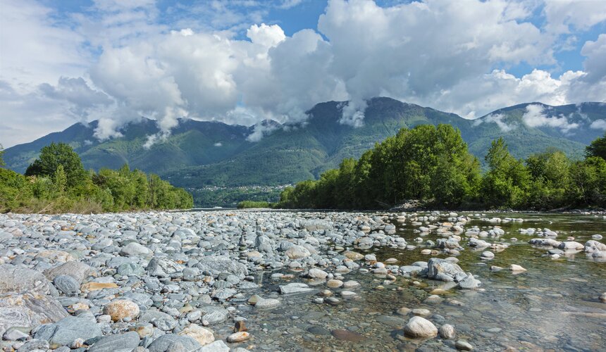
The latest European State of the Climate report states that, last year, Europe suffered its hottest summer on record. The heat and a persistent lack of rain caused drought which, at its peak, affected much of the continent. This not only illustrates the reality of climate change, but also how precarious our supply of freshwater can be, even in western Europe where the climate is relatively moderate.
By delivering frequent and accurate gravity measurements, a new space mission called MAGIC, a cooperation between ESA and NASA, will help make the important task of managing our precious water supplies more efficient.
Earth from Space: Rome, Italy
21.4.2023 10:00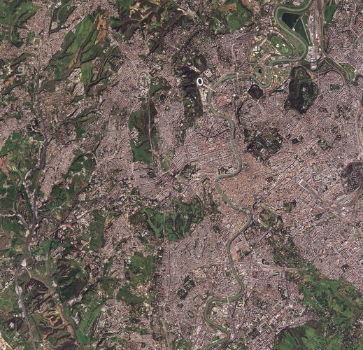 Image:
The historic centre of Rome, Italy’s capital city, is featured in this image captured on 28 March 2023.
Image:
The historic centre of Rome, Italy’s capital city, is featured in this image captured on 28 March 2023.
Introducing World Cereal
20.4.2023 14:05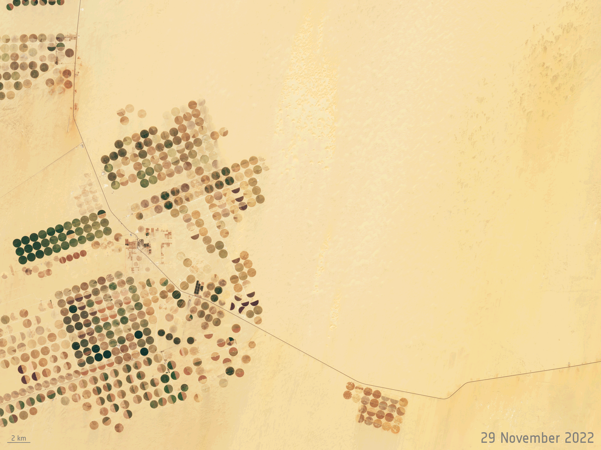
Global food security is a major challenge in the face of population growth and climate change. One of the first steps in achieving food security for all is to know which crops are growing where and how – each season. Launching today, ESA’s WorldCereal is the world’s first dynamic system capable of providing seasonally updated crop information to help monitor agricultural production across the globe.
Ice loss from Greenland and Antarctica hits new record
20.4.2023 9:00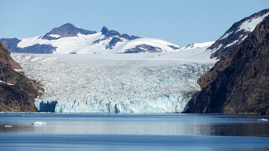
A report, publishing today, states that ice loss from Greenland and Antarctica has increased fivefold since the 1990s, and now accounts for a quarter of sea-level rise.
Ice loss from Greenland and Antarctica hits new record
20.4.2023 9:00
A report, released today, states that ice loss from Greenland and Antarctica has increased fivefold since the 1990s, and now accounts for a quarter of sea-level rise.
How much water do we use for irrigation?
19.4.2023 16:04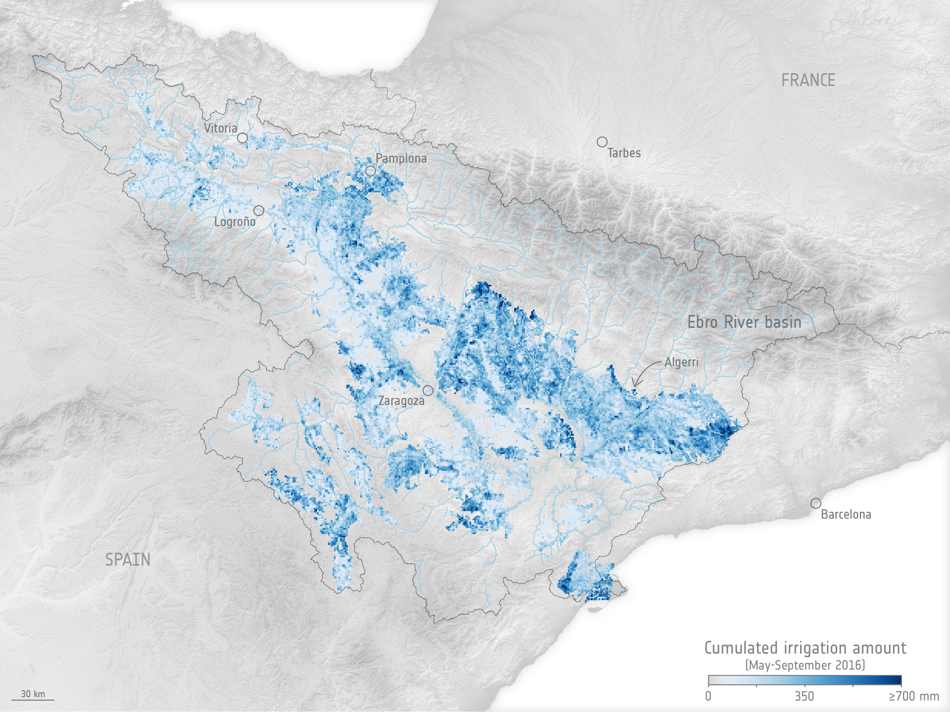
While we know that we use more water for irrigation than for any other single purpose, watering practices are not monitored worldwide. Water needed for agriculture is expected to further increase as time goes on, so managing this precious resource as effectively as possible is imperative. Scientists have now shown that a nifty way of using information from satellites could pave to way to measuring how much water we use to irrigate, which could subsequently lead to better management.
How much water do we use for irrigation?
19.4.2023 16:04
While we know that we use more water for irrigation than for any other single purpose, watering practices are not monitored worldwide. Water needed for agriculture is expected to further increase as time goes on, so managing this precious resource as effectively as possible is imperative. Scientists have now shown that a nifty way of using information from satellites could pave the way to measuring how much water we use to irrigate, which could subsequently lead to better management.
10 remarkable Earth facts
18.4.2023 15:25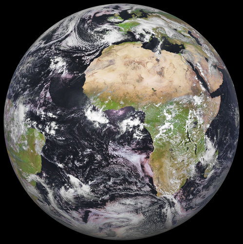
Every year on 22 April, we’ve celebrated Earth Day and the beautiful planet we call home. Earth Day, established in 1970, has been used to highlight our planet’s environmental challenges and raise awareness of the importance of protecting our world for future generations. But shouldn’t every day be Earth Day? We only have one beautiful planet after all. We hope you enjoy this curated list of 10 of the most remarkable facts about Earth.
Scroll to the end of the article to take part in ESA's Earth Day 2023 campaign.
10 remarkable Earth facts
18.4.2023 15:25
Every year on 22 April, we’ve celebrated Earth Day and the beautiful planet we call home. Earth Day, established in 1970, has been used to highlight our planet’s environmental challenges and raise awareness of the importance of protecting our world for future generations. But shouldn’t every day be Earth Day? We only have one beautiful planet after all. We hope you enjoy this curated list of 10 of the most remarkable facts about Earth.
Scroll to the end of the article to take part in ESA's 'You like, we plant' campaign.
Trailblazing Aeolus mission winding down
18.4.2023 13:10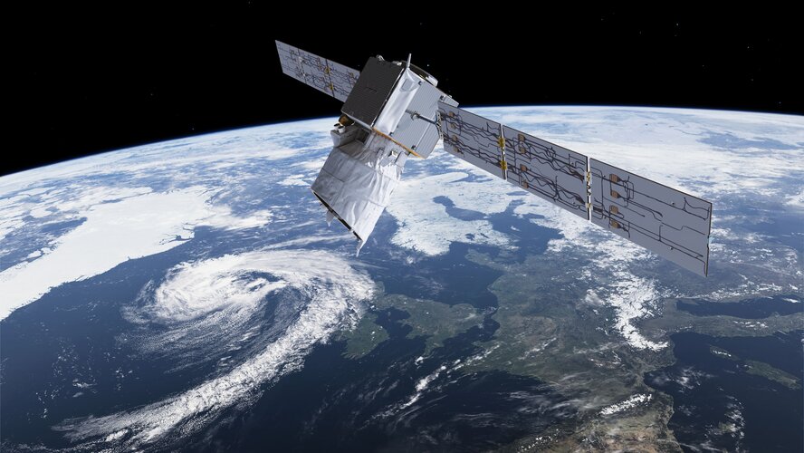
On 30 April 2023, all nominal operations of Aeolus, the first mission to observe Earth’s wind profiles on a global scale, will conclude in preparation for a series of end-of-life activities.
Trailblazing Aeolus mission winding down
18.4.2023 13:10
On 30 April 2023, all nominal operations of Aeolus, the first mission to observe Earth’s wind profiles on a global scale, will conclude in preparation for a series of end of life activities.
13 volcanoes seen from space
10.4.2023 10:00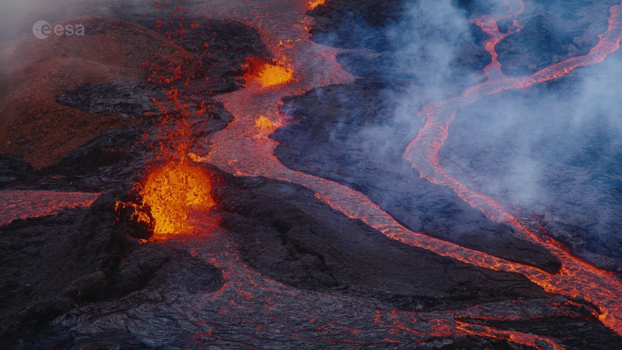 Video:
00:12:09
Video:
00:12:09
Have you ever wondered what a volcano looks like from space? Today, we’re counting down our picks of the most impressive volcanoes around the world – captured by satellites. Our countdown includes Mount Fuji, Mount Mayon and Mount Vesuvius. Satellites orbiting 800 km above us can monitor volcanoes. They can provide real-time data on volcanic activity and can even help disaster response efforts post-eruption.
Smelly seaweed bloom heads to Florida
7.4.2023 14:30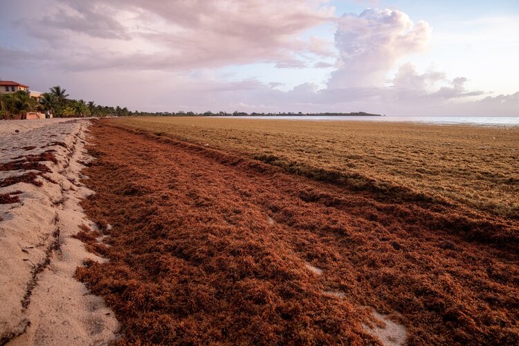
A large mass of Sargassum ‘seaweed’ circling around the Gulf of Mexico may soon wash up along the US west coast near Florida – depending on the right combination of currents and wind. The bloom, which may likely be the largest ever recorded, is so large that it’s visible from space.
Earth from Space: Seoul, South Korea
7.4.2023 10:00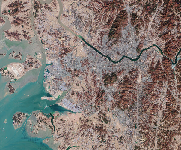 Image:
South Korea’s capital city, Seoul, and surroundings are featured in this image, captured by the Copernicus Sentinel-2 mission on 21 February 2023.
Image:
South Korea’s capital city, Seoul, and surroundings are featured in this image, captured by the Copernicus Sentinel-2 mission on 21 February 2023.
Revealing invisible Himalaya glacier loss
7.4.2023 9:00
New research reveals that ice being lost from glaciers that flow into lakes in the Himalayas has been significantly underestimated. This discovery has critical implications for predicting the demise of the region’s glaciers and for managing critical water resources.
Untangling the ocean biological carbon pump
6.4.2023 15:38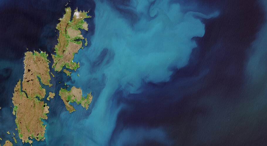
They may be microscopic, but their ability to sequester carbon is phenomenal. We are talking phytoplankton – and scientists working on a project funded by ESA are assessing different aspects of the role that these tiny plants play in the ocean carbon cycle to better understand climate processes.
EO Science Strategy workshop
4.4.2023 11:00
Register for the EO Science Strategy workshop
19-20 June – Bruges, Belgium
EO Science Strategy workshop
4.4.2023 11:00
Register for Earth Observation Science Strategy workshop
19-20 June – Bruges, Belgium
EO Science Strategy workshop
4.4.2023 11:00
EO Science Strategy workshop
19-20 June – Bruges, Belgium
Runoff: not as you might think
3.4.2023 14:38
Runoff and river discharge are important components in Earth’s water cycle, but as climate change tightens its grip, heatwaves and instances of drought are increasingly hitting the headlines. One would assume that this hotter weather leads to reduced water runoff, but an innovative way of using information from satellites suggests that this isn’t always the case.
Is Europe already drying up?
31.3.2023 10:55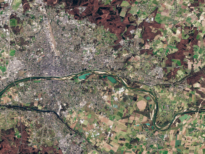
Europe has just endured its second warmest winter on record. Much of southern and western Europe has been affected by substantial anomalies of soil moisture owing to this exceptionally dry and warm winter. Data from ESA’s Soil Moisture and Ocean Salinity mission have been used to monitor the low levels of soil moisture across Europe.
Earth from Space: Pollino National Park, Italy
31.3.2023 10:00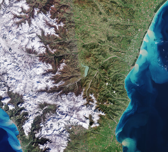 Image:
Part of southern Italy is featured in this wintery image, captured by the Copernicus Sentinel-2 mission.
Image:
Part of southern Italy is featured in this wintery image, captured by the Copernicus Sentinel-2 mission.
ESA–EGU 2023 Excellence Award winners
28.3.2023 15:12
Honouring individual scientists and teams of scientists that have contributed to the innovative use of Earth observation data, ESA and the European Geosciences Union (EGU) are happy to announce the winners of this year’s prestigious Excellence Award.
Earth from Space: Monterrey, Mexico
24.3.2023 10:00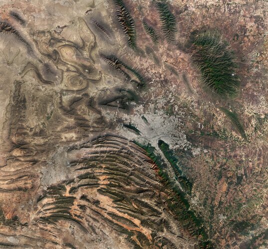 Image:
This Copernicus Sentinel-2 image features the diverse landscape surrounding Monterrey, the capital of the northeast state of Nuevo León, Mexico.
Image:
This Copernicus Sentinel-2 image features the diverse landscape surrounding Monterrey, the capital of the northeast state of Nuevo León, Mexico.
Earth observation supports latest UN climate report
20.3.2023 16:30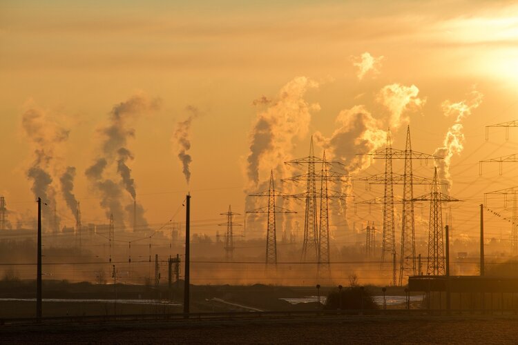
The final instalment of the sixth assessment report by the United Nations' Intergovernmental Panel on Climate Change (IPCC) has been released today. The report warns that the planet has already warmed 1.1°C above pre-industrial levels, resulting in more frequent and intense extreme weather events that are causing increasingly dangerous impacts on nature and people in every region of the world.
The report includes a greater contribution of Earth observation data than its previous iterations in providing the physical evidence of Earth’s changing climate system – from sea-level rise, growing greenhouse-gas emissions and melting sea ice.
Earth from Space: Okavango Delta, Botswana
17.3.2023 10:00 Image:
Botswana’s Okavango Delta – the world’s largest inland delta – is featured in this multitemporal radar image, captured by the Copernicus Sentinel-1 mission.
Image:
Botswana’s Okavango Delta – the world’s largest inland delta – is featured in this multitemporal radar image, captured by the Copernicus Sentinel-1 mission.
Clement Albergel on forests and the carbon cycle
15.3.2023 11:08 Video:
00:01:21
Video:
00:01:21
Tropical forests are vital ecosystems in the fight against climate change. Yet vast areas of forest are still degraded or lost through deforestation and environmental changes. Clement Albergel, Climate Applications Scientist at ESA, explains how satellite observations can not only help us to monitor deforestation, but provide valuable information on secondary and degraded forests as well as how much carbon they accumulate.
Reforestation in Rio Capim, Amazon
15.3.2023 10:58 Video:
00:00:08
Video:
00:00:08
A series of USGS Landsat and Copernicus Sentinel-2 images showing secondary forest regrowth near Rio Capim, in the Brazilian Amazon, from 1985 to 2022.
Carbon dioxide monitoring mission in development
14.3.2023 11:00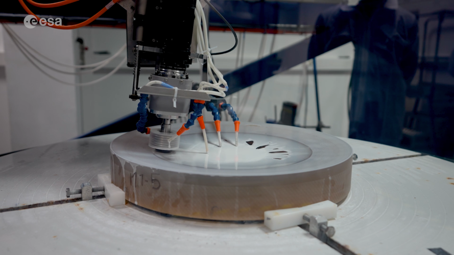 Video:
00:04:58
Video:
00:04:58
The pressure is on to reduce the amount of greenhouse gases we pump into the atmosphere – but the race is also on to support the monitoring that shows if targets are being met. Being developed by ESA on behalf of the EU, the new Copernicus Anthropogenic Carbon Dioxide Monitoring mission, or CO2M for short, is destined to be Europe’s prime mission for monitoring and tracking carbon dioxide emissions from human activity. CO2M is currently planned as a two-satellite mission, each of which will carry a near-infrared and shortwave-infrared spectrometer to measure atmospheric carbon dioxide at high spatial resolution. Engineers at Thales SESO in France explain how the development of some of the mission’s precision measuring and optical components is going.
Earth from Space: Graham Coast, Antarctica
10.3.2023 10:00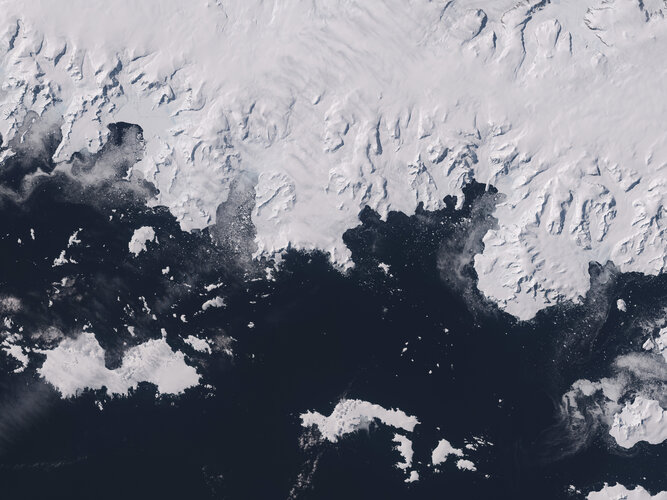 Image:
The icy landscape of Graham Coast, which lies on the west side of the Antarctic Peninsula, is featured in this Copernicus Sentinel-2 image.
Image:
The icy landscape of Graham Coast, which lies on the west side of the Antarctic Peninsula, is featured in this Copernicus Sentinel-2 image.
HydroGNSS twice as good
6.3.2023 14:57
ESA’s HydroGNSS mission will now comprise two identical satellites to halve the time it takes to revisit the same place on Earth’s surface and re-measure various climate variables such soil moisture. Having two satellites in orbit will significantly improve the science that this exciting new Scout mission will yield.
Earth from Space: Poyang Lake, China
3.3.2023 10:00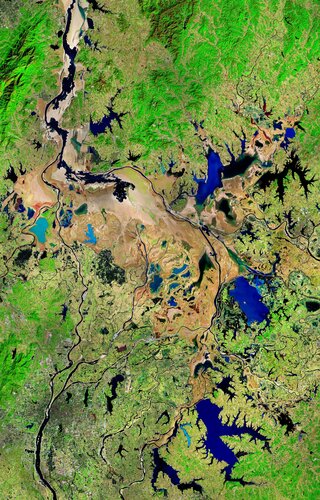 Image:
This Copernicus Sentinel-2 image shows Poyang Lake in China’s Jiangxi Province during winter.
Image:
This Copernicus Sentinel-2 image shows Poyang Lake in China’s Jiangxi Province during winter.
Antarctic Peninsula glaciers on the run
27.2.2023 17:00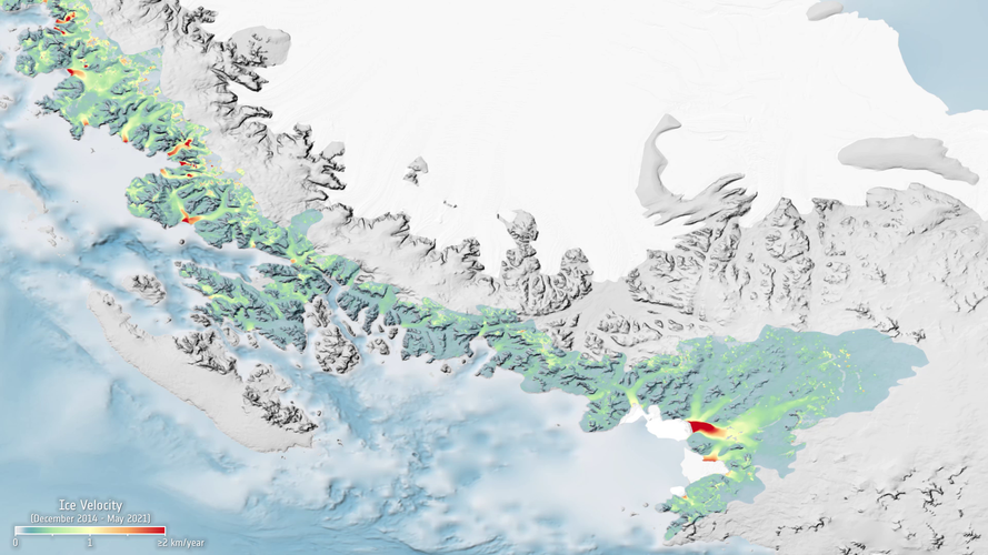
Like many places, the Antarctic Peninsula is falling victim to rising temperatures. However, when scientists used radar images from the Copernicus Sentinel-1 mission acquired between 2014 and 2021, they were taken aback to discover just how the fast 105 glaciers on the west coast are flowing in the summer months.
Earth from Space: The Triple Frontier
24.2.2023 10:00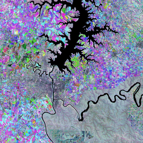 Image:
The Triple Frontier, a region where Paraguay, Brazil and Argentina meet, is featured in this false-colour image, captured by the Copernicus Sentinel-2 mission.
Image:
The Triple Frontier, a region where Paraguay, Brazil and Argentina meet, is featured in this false-colour image, captured by the Copernicus Sentinel-2 mission.
ESA’s forest satellite robust for launch
23.2.2023 14:00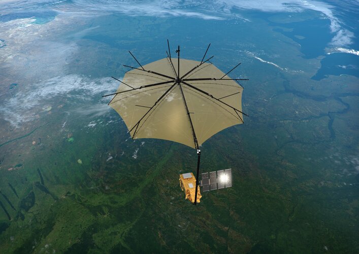
Over the last few months, ESA’s Earth Explorer Biomass satellite has been going through a punishing series of tests to make sure that it will survive the unavoidable blasts of noise and shuddering during liftoff. Engineers have now also tested that it will unfold its solar wing in the correct sequence. Coming through all of this with flying colours, Biomass is a few steps closer to its mission in orbit: to deliver completely new information on our precious forests and the carbon they store.
The ozone layer: a whole new world
23.2.2023 13:00 Video:
00:08:47
Video:
00:08:47
In the 1980s, scientists discovered a gaping hole in Earth's ozone layer, caused by humanmade chemicals. But thanks to the historical Montreal Protocol, the world came together to take bold action to save our planet. Decades later, we can see the steady recovery of the ozone hole. How did we do it? And what does space have to do with it? Join us as we explore the journey of the ozone hole, from its alarming discovery to the incredible strides made to fix it, and how satellites are helping us track its recovery.
The ozone layer: a hole new world
23.2.2023 13:00 Video:
00:08:47
Video:
00:08:47
In the 1980s, scientists discovered a gaping hole in Earth's ozone layer, caused by humanmade chemicals. But thanks to the historical Montreal Protocol, the world came together to take bold action to save our planet. Decades later, we can see the steady recovery of the ozone hole. How did we do it? And what does space have to do with it? Join us as we explore the journey of the ozone hole, from its alarming discovery to the incredible strides made to fix it, and how satellites are helping us track its recovery.
Copernicus Sentinel-2 helps explorers unearth rare 7.6 kg meteorite in Antarctica
21.2.2023 11:03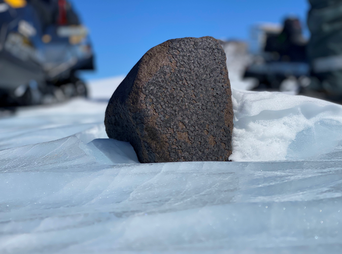
Copernicus Sentinel-2 helps explorers unearth rare meteorite
Call opens for ESA’s twelfth Earth Explorer
20.2.2023 12:00
Understanding Earth’s delicate natural balance and how it is being altered by human activity is not only key to advancing science but also fundamental to acting on environmental issues, the climate crisis, and preparing for their societal impact. With their hallmark of demonstrating novel space technologies and returning scientific excellence, ESA’s family of Earth observing Earth Explorer research satellite missions are world-renowned – and now it’s time for scientists to pitch their new ideas for the twelfth mission in this outstanding series.
Earth from Space: Liverpool Land, Greenland
17.2.2023 10:00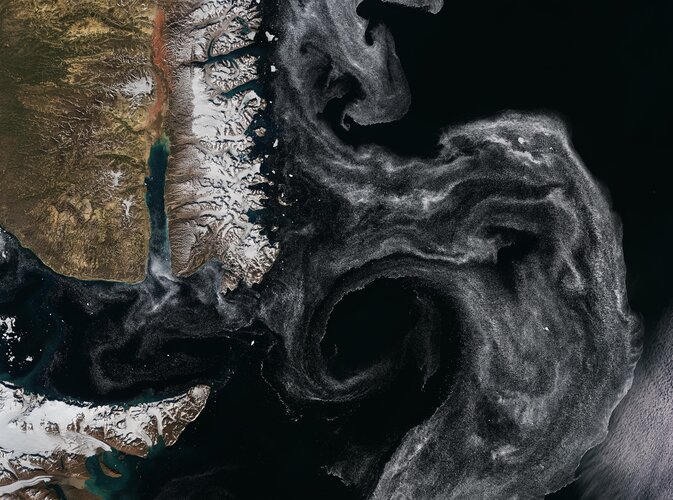 Image:
The Liverpool Land peninsula, on the east coast of Greenland, is featured in this Copernicus Sentinel-2 image.
Image:
The Liverpool Land peninsula, on the east coast of Greenland, is featured in this Copernicus Sentinel-2 image.
Satellite data now used for road infrastructure safety in Italy
16.2.2023 11:00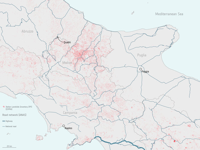
A new ground motion service utilising Copernicus satellite data is being used by the Italian road agency to detect and monitor unstable ground – helping improve nationwide road infrastructure safety.
Satellite data used for road infrastructure safety in Italy
16.2.2023 11:00
A new ground motion service utilising Copernicus satellite data is being used by the Italian road agency to detect and monitor unstable ground – helping improve nationwide road infrastructure safety.
Boosting market traction for agri-monitoring service
15.2.2023 14:00
Support from ESA’s Earth observation InCubed commercialisation programme has enabled two companies, GeoVille and EOX, to secure a major contract to provide an Austrian Area Monitoring Service. The consortium’s EO-WIDGET software provides the farming sector with critical satellite-derived information and is a key tool in compliance monitoring for the European Common Agricultural Policy.
Satellites support impact assessment after Türkiye–Syria earthquakes
13.2.2023 12:45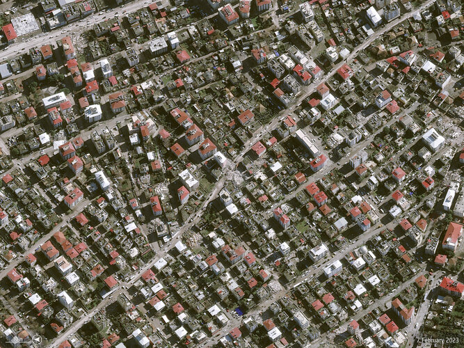
Türkiye and Syria are reeling from one of the worst earthquakes to strike the region in almost a century. Tens of thousands of people have been killed with many more injured in this tragedy.
Satellite data are being used to help emergency aid organisations, while scientists have begun to analyse ground movement – aiding risk assessments that authorities will use as they plan recovery and reconstruction, as well as long-term research to better model such events.
Earth from Space: Swedish landscape
10.2.2023 10:00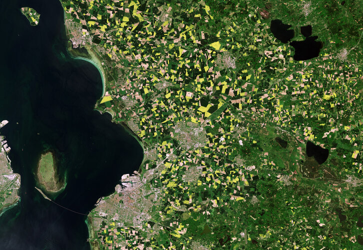 Image:
Agricultural fields that surround the cities of Lund and Malmö in Sweden are pictured in this image, captured by the Copernicus Sentinel-2 mission.
Image:
Agricultural fields that surround the cities of Lund and Malmö in Sweden are pictured in this image, captured by the Copernicus Sentinel-2 mission.
Sentinel-4 set to join next weather satellite
9.2.2023 9:53
Copernicus Sentinel-4, which is set to play a key role in monitoring air quality over Europe, is ready to be fitted to its host, the first Meteosat Third Generation Sounder weather satellite.
Copernicus Sentinel-4 is a state-of-the-art ultraviolet, visible, near-infrared spectrometer instrument that has been developed to deliver hourly high-resolution measurements of trace gases such as nitrogen dioxide, ozone, sulphur dioxide and formaldehyde, as well as aerosols.
Europe’s next radar satellite tip-top for flight
7.2.2023 15:59
Following its arrival at Thales Alenia Space’s cleanroom facilities in the south of France last October, Europe’s next radar satellite, Copernicus Sentinel-1C, has been put through its paces in a series of tests and demonstrated that it is in tip-top condition for flight. Engineers have also carried out the all-important and precise check to ensure that the satellite fits on the adapter that connects it to the rocket that will take it into orbit.
Chile battles raging wildfires
7.2.2023 14:26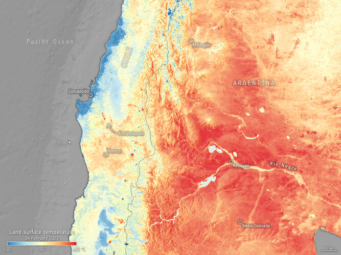 Image:
Deadly wildfires continue to rage in south-central Chile destroying hundreds of thousands of hectares of land across the country. Satellite images captured by the Copernicus Sentinel-3 mission on 4 February show the ongoing fires and heatwave in South America.
Image:
Deadly wildfires continue to rage in south-central Chile destroying hundreds of thousands of hectares of land across the country. Satellite images captured by the Copernicus Sentinel-3 mission on 4 February show the ongoing fires and heatwave in South America.
Earth from Space: Kolkata, India
3.2.2023 10:00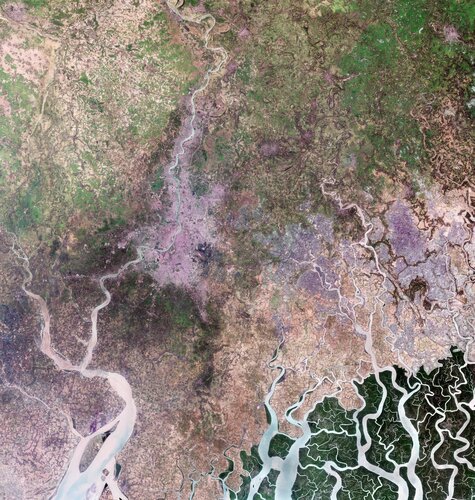 Image:
Kolkata, formerly Calcutta, is featured in this image, captured by the Copernicus Sentinel-2 mission.
Image:
Kolkata, formerly Calcutta, is featured in this image, captured by the Copernicus Sentinel-2 mission.
Iceberg larger than London breaks off Brunt
27.1.2023 15:00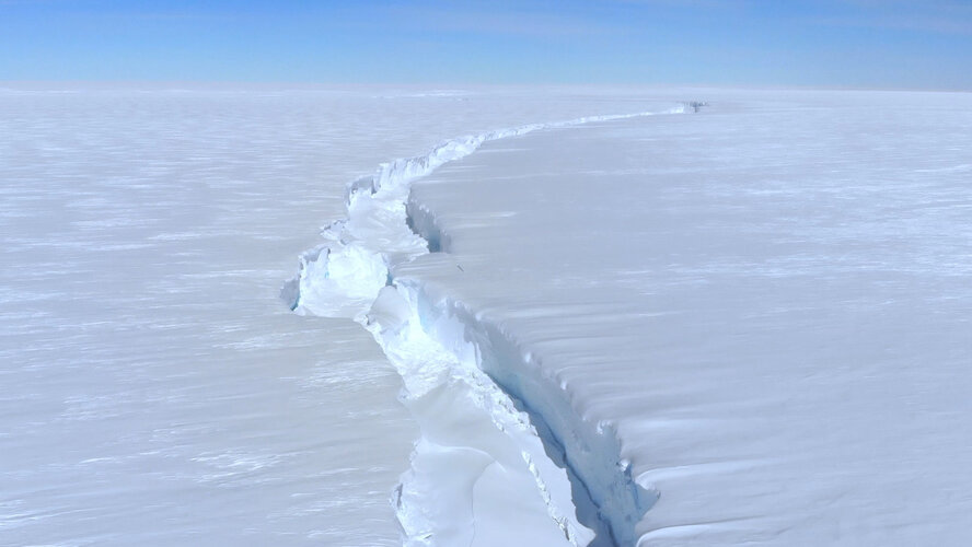 Video:
00:04:25
Video:
00:04:25
An iceberg around the size of Greater London broke off Antarctica’s Brunt Ice Shelf due to a natural process called ‘calving’. The iceberg, measuring 1550 sq km, detached from the 150 m-thick ice shelf a decade after scientists first spotted massive cracks in the shelf.
For more information on the newly-birthed A81 iceberg, click here.
Radar images capture new Antarctic mega-iceberg
26.1.2023 16:27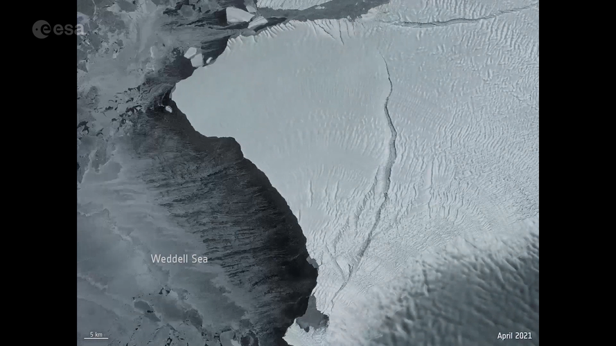 Video:
00:00:23
Video:
00:00:23
Using radar images from the Copernicus Sentinel-1 mission, the animation shows the A81 iceberg breaking away from the Brunt Ice Shelf on 25 January 2023. The new berg is estimated to be around 1550 sq km, which is around the size of Greater London, and is approximately 150 m thick. It calved when the crack known as Chasm-1 split northwards severing the west part of the ice shelf.
The white square indicated the final breakpoint near the McDonald Ice Rumples.
Routine monitoring from satellites offers unparalleled views of events happening in remote regions. The Copernicus Sentinel-1 mission carries radar, which can return images regardless of day or night and this allows us year-round viewing, which is especially important through the long, dark, austral winter months.
Read the full story: Giant iceberg breaks away from Antarctic ice shelf
Giant iceberg breaks away from Antarctic ice shelf
25.1.2023 15:45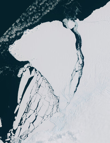
Satellite imagery confirms an enormous iceberg, around five times the size of Malta, has finally calved from Antarctica’s Brunt Ice Shelf. The new berg, estimated to be around 1550 sq km and around 150 m thick, calved when the crack known as Chasm-1 fully extended northwards severing the west part of the ice shelf.
This crack was first revealed to be extending in early 2012 after having been dormant for some decades. After several years of desperately clinging on, image data from the Copernicus Sentinel missions visually confirm the calving event.
ESA and the European Commission uniting on Earth observation for the Philippines
24.1.2023 14:00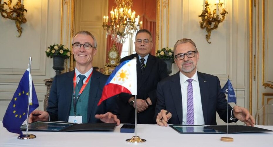
ESA and the European Commission have signed a contribution agreement to build a Copernicus mirror site in the Philippines – the first of its kind in southeast Asia. The new CopPhil initiative will enhance the response capability and resilience of the Philippines to natural and human made disasters through the strategic use of space data. This will help reduce vulnerability of the nation to climate hazards, support climate adaption, food security and environmental protection.
Future-proofing ice measurements from space
19.1.2023 15:06
With diminishing ice one of the biggest casualties of our warming world, it’s imperative that accurate measurements continue to be made for scientific research and climate policy, as well as for practical applications such as ship routing. To ensure that ESA and NASA are getting the best out of their ice-measuring satellites and to help prepare for Europe’s new CRISTAL satellite, the two space agencies along with the British Antarctic Survey and a team of scientists teamed up recently to carry out an ambitious campaign in Antarctica.
Future-proofing ice measurements from space
19.1.2023 15:06
With diminishing ice one of the biggest casualties of our warming world, it’s imperative that accurate measurements continue to be made for scientific research and climate policy, as well as for practical applications such as ship routing.
To ensure that ESA and NASA are getting the best out of their ice-measuring satellites and to help prepare for Europe’s new CRISTAL satellite, the two space agencies along with the British Antarctic Survey and a team of scientists teamed up recently to carry out an ambitious campaign in Antarctica.
Looking back at the eruption that shook the world
16.1.2023 11:05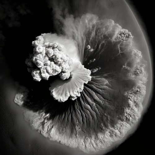
One year ago, the Hunga Tonga-Hunga Ha’apai volcano erupted, causing widespread destruction to the Pacific Island Nation of Tonga, spewing volcanic material up to 58 km into the atmosphere. It brought a nearly 15 m tsunami that crashed ashore, destroying villages, and creating a sonic boom that rippled around the world – twice.
Satellites orbiting Earth scrambled to capture images and data of the aftermath of the disaster. Almost a year later, you can now listen to a sonification of the largest eruption of the 21st Century, created using wind data from ESA’s Aeolus mission.
Snowless ski slopes from space
12.1.2023 12:00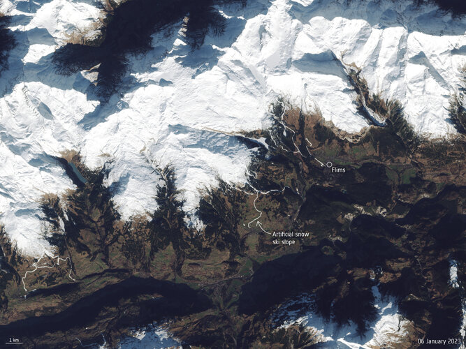 Image:
Europe has kicked off the new year with an intense winter heatwave. The warm temperatures and lack of snowfall in the Alps has left several ski resorts with little or no snow. The difference in snow cover is visible in these Copernicus Sentinel-2 images captured in January 2022 compared to January 2023.
Image:
Europe has kicked off the new year with an intense winter heatwave. The warm temperatures and lack of snowfall in the Alps has left several ski resorts with little or no snow. The difference in snow cover is visible in these Copernicus Sentinel-2 images captured in January 2022 compared to January 2023.
Sentinel-1 and AI uncover glacier crevasses
9.1.2023 15:32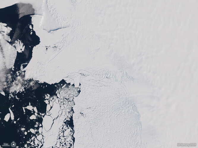
Scientists have developed a new Artificial Intelligence, or AI, technique using radar images from Europe’s Copernicus Sentinel-1 satellite mission, to reveal how the Thwaites Glacier Ice Tongue in West Antarctica is being damaged by squeezing and stretching as it flows from the middle of the continent to the coast. Being able to track fractures and crevasses in the ice beneath the overlying snow is key to better predicting the fate of floating ice tongues under climate change.
Snowy Alps
21.12.2022 11:55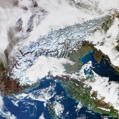 Image:
This Copernicus Sentinel-3 image shows the wide-coverage of snowfall in the Alps, which hopefully bodes well for the coming year.
Image:
This Copernicus Sentinel-3 image shows the wide-coverage of snowfall in the Alps, which hopefully bodes well for the coming year.
Snowy Lapland and the white balloon
16.12.2022 14:12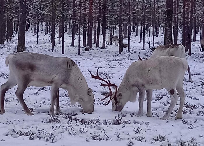
At this time of the year, the mention of Lapland conjures up visions of Santa getting his gift-laden sleigh and nine reindeer ready to take to the skies for the most important deliveries of all. However, the skies of Lapland have witnessed something rather different recently – a big white balloon, which may not provide the immediate gratification of a much-wanted Christmas present, but nonetheless plays a role in helping to safeguard our children’s future.
Earth from Space: Dublin, Ireland
16.12.2022 10:00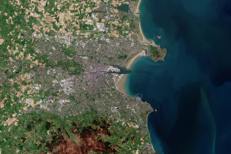
Dublin, the capital and largest city of Ireland, is featured in this image captured by Copernicus Sentinel-2.
Christmas comes early for Aeolus
15.12.2022 15:25
ESA’s wind mission continues to shine as engineers have worked their Christmas magic. With a switch back to its original laser, Aeolus is now shining more than twice as brightly with its best ever performance – just in time for the holidays.
A new era of weather forecasting begins
14.12.2022 0:05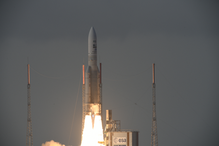
The Meteosat Third Generation Imager satellite, set to revolutionise short-term weather forecasting in Europe, lifted off on an Ariane 5 rocket at 21:30 CET (17:30 local time in Kourou) on 13 December from Europe’s Spaceport in French Guiana.
The satellite separated from the rocket 34 minutes later and then Malindi ground station in Kenya received the signal from MTG-I1, indicating the satellite is in good health.
A new era of weather forecasting begins
14.12.2022 0:05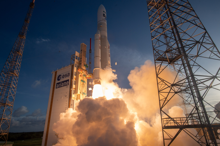
The Meteosat Third Generation Imager satellite, set to revolutionise short-term weather forecasting in Europe, lifted off on an Ariane 5 rocket at 21:30 CET (17:30 local time in Kourou) on 13 December from Europe’s Spaceport in French Guiana.
The satellite separated from the rocket 34 minutes later and then Malindi ground station in Kenya received the signal from MTG-I1, indicating the satellite is in good health.
MTG-I1 launch coverage
13.12.2022 23:00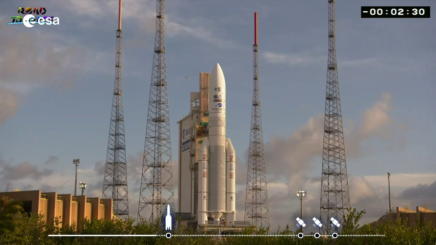 Video:
00:03:13
Video:
00:03:13
Watch the replay the MTG-I1 launch coverage. The video includes streaming of the event at ESA’s ESTEC establishment in the Netherlands and footage of liftoff from Europe’s Spaceport in French Guiana.
The first Meteosat Third Generation Imager (MTG-I1) satellite lifted off on an Ariane 5 rocket from Europe’s Spaceport in French Guiana on 13 December at 21:30 CET.
From geostationary orbit, 36,000 km above the equator, this all-new weather satellite will provide state-of-the art observations of Earth’s atmosphere and realtime monitoring of lightning events, taking weather forecasting to the next level. The satellite carries two completely new instruments: Europe’s first Lightning Imager and a Flexible Combined Imager.
MTG-I1 is the first of six satellites that form the full MTG system, which will provide critical data for weather forecasting over the next 20 years. In full operations, the mission will comprise two MTG-I satellites and one MTG Sounding (MTG-S) satellites working in tandem.
The MTG mission is a cooperation between Eumetsat and ESA. ESA is responsible developing and procuring the six MTG satellites. Eumetsat defines the system requirements, develops the ground systems, procures the launch services, operates the satellites, and makes the data available to users.
MTG-I1 launch coverage
13.12.2022 23:00
Video:
03:13:00
Watch the replay the MTG-I1 launch coverage. The video includes streaming of the event at ESA’s ESTEC establishment in the Netherlands and footage of liftoff from Europe’s Spaceport in French Guiana.
The first Meteosat Third Generation Imager (MTG-I1) satellite lifted off on an Ariane 5 rocket from Europe’s Spaceport in French Guiana on 13 December at 21:30 CET.
From geostationary orbit, 36,000 km above the equator, this all-new weather satellite will provide state-of-the art observations of Earth’s atmosphere and realtime monitoring of lightning events, taking weather forecasting to the next level. The satellite carries two completely new instruments: Europe’s first Lightning Imager and a Flexible Combined Imager.
MTG-I1 is the first of six satellites that form the full MTG system, which will provide critical data for weather forecasting over the next 20 years. In full operations, the mission will comprise two MTG-I satellites and one MTG Sounding (MTG-S) satellites working in tandem.
The MTG mission is a cooperation between Eumetsat and ESA. ESA is responsible developing and procuring the six MTG satellites. Eumetsat defines the system requirements, develops the ground systems, procures the launch services, operates the satellites, and makes the data available to users.
MTG-I1 launch coverage
13.12.2022 23:00 Video:
03:13:00
Video:
03:13:00
Watch the replay the MTG-I1 launch coverage. The video includes streaming of the event at ESA’s ESTEC establishment in the Netherlands and footage of liftoff from Europe’s Spaceport in French Guiana.
The first Meteosat Third Generation Imager (MTG-I1) satellite lifted off on an Ariane 5 rocket from Europe’s Spaceport in French Guiana on 13 December at 21:30 CET.
From geostationary orbit, 36,000 km above the equator, this all-new weather satellite will provide state-of-the art observations of Earth’s atmosphere and realtime monitoring of lightning events, taking weather forecasting to the next level. The satellite carries two completely new instruments: Europe’s first Lightning Imager and a Flexible Combined Imager.
MTG-I1 is the first of six satellites that form the full MTG system, which will provide critical data for weather forecasting over the next 20 years. In full operations, the mission will comprise two MTG-I satellites and one MTG Sounding (MTG-S) satellites working in tandem.
The MTG mission is a cooperation between Eumetsat and ESA. ESA is responsible developing and procuring the six MTG satellites. Eumetsat defines the system requirements, develops the ground systems, procures the launch services, operates the satellites, and makes the data available to users.