


ESA Observing the Earth 
zdroje zpráv:
Global lake warming trend threatens freshwater species
9.10.2020 14:33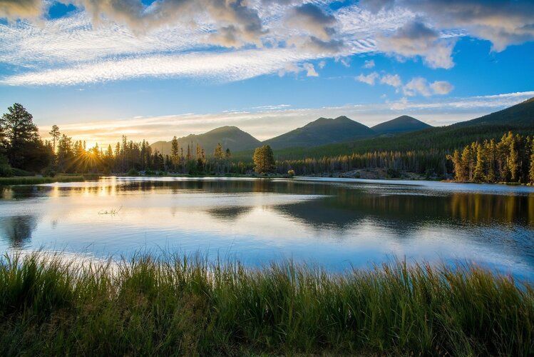
Holding over 80% of Earth’s surface freshwater, lakes support and sustain communities across the planet. A new study uses satellite data to underline the vulnerability of these inland water bodies to climate change and warns of serious future consequences for many freshwater species worldwide.
Earth from Space: Laguna San Rafael National Park, Chile
9.10.2020 10:00 Video:
00:03:49
Video:
00:03:49
In this week's edition of the Earth from Space programme, we explore part of the Laguna San Rafael National Park, Chile, with Copernicus Sentinel-2.
See also Laguna San Rafael National Park, Chile to download the image.
Laguna San Rafael National Park, Chile
9.10.2020 10:00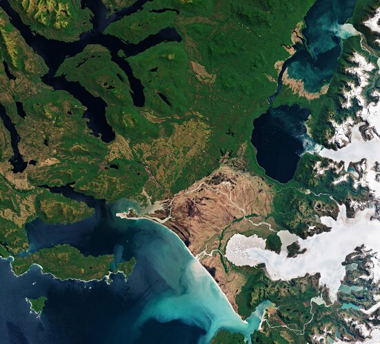 Image:
Part of the Laguna San Rafael National Park, located on the Pacific coast of southern Chile, is pictured in this image captured by Copernicus Sentinel-2.
Image:
Part of the Laguna San Rafael National Park, located on the Pacific coast of southern Chile, is pictured in this image captured by Copernicus Sentinel-2.
ESA's Kiruna celebrates 30 years of space excellence
7.10.2020 14:00 Video:
00:13:37
Video:
00:13:37
September 2020 - ESA's Kiruna ground station in northern Sweden celebrates 30 years of space excellence. Near the top of the world, at a latitude of almost 68° north and sited 38 kilometres east of Kiruna town, the Kiruna ground station has been operational for 30 years. Ideally positioned to support polar-orbiting missions, the station is a crucial gateway for much of the data enabling us to study our planet's oceans, water and atmosphere, forecast weather and understand the rapid advance of climate change. With its two sophisticated antennas, it also supports some of ESA’s scientific missions such as Integral and Cluster. The station is part of ESA’s Estrack network linking all Agency missions to the ESOC mission control centre in Darmstadt, Germany.
The Arctic: a delicate icy ecosystem
5.10.2020 10:00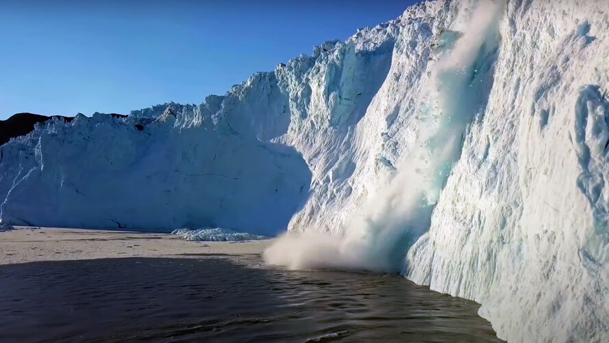 Video:
00:08:21
Video:
00:08:21
The Arctic is one of the most rapidly changing regions in the world. Diminishing sea ice, thawing permafrost and melting glaciers are all direct effects of rising global temperatures – driven by human-made emissions. Learn more about how satellites flying 800 km above our heads can help us monitor and understand the changes occurring in this remote region.
New York City
2.10.2020 10:00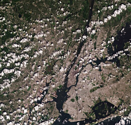 Image:
The Copernicus Sentinel-2 mission takes us over New York City – the most populous city in the United States.
Image:
The Copernicus Sentinel-2 mission takes us over New York City – the most populous city in the United States.
Earth from Space: New York City
2.10.2020 10:00 Video:
00:03:22
Video:
00:03:22
In this week's edition of the Earth from Space programme, the Copernicus Sentinel-2 mission takes us over New York City – the most populous city in the United States.
See also New York City to download the image.
Earth from Space: New York City
2.10.2020 10:00
Video:
00:03:22
In this week's edition of the Earth from Space programme, the Copernicus Sentinel-2 mission takes us over New York City – the most populous city in the United States.
See also New York City to download the image.
Monitoring trucks and trade from space
1.10.2020 17:50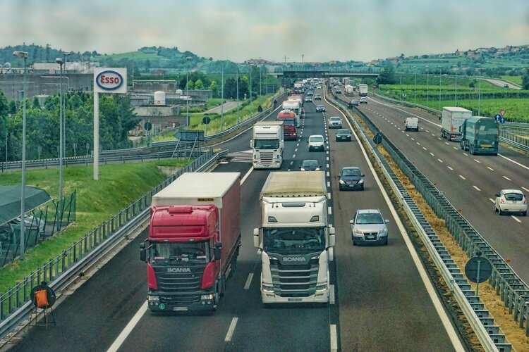
Earlier this year, ESA launched a contest asking the general public to submit ideas on how Earth observation data can help mitigate the effects of the COVID-19 pandemic. Today, one of the two winning ideas is being officially released to the public via the ‘Rapid Action on COVID-19 with Earth Observation’ dashboard – a joint initiative from ESA and the European Commission. This citizen-contributed indicator involves an innovative solution for detecting and quantifying the number of trucks using imagery from the Copernicus Sentinel-2 mission.
Relive Φ-week 2020
1.10.2020 11:50
Replay the livestream of ESA’s ɸ-week, which brought together leading scientists and entrepreneurs from all over the world to discuss and brainstorm scientific and technological opportunities brought by the concept of Digital Twin Earth.
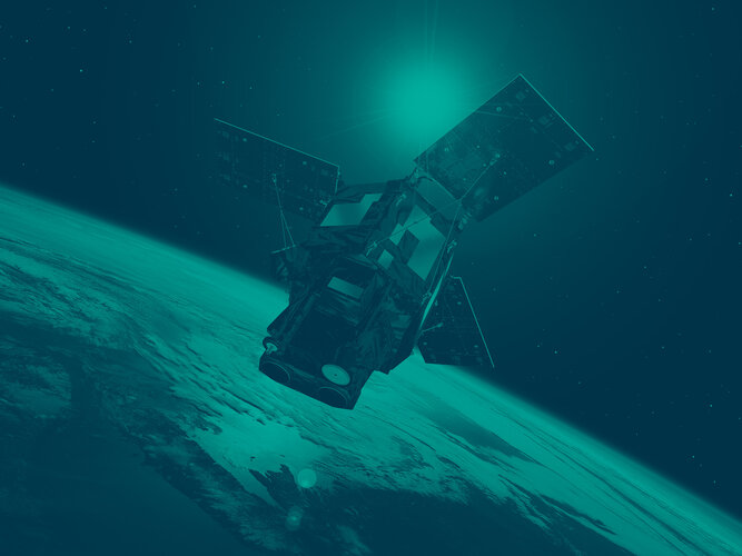
Copernicus Sentinel-6 Michael Freilich: preparing for launch
29.9.2020 14:00 Video:
00:03:10
Video:
00:03:10
A European satellite built to carry out precise measurements of sea level changes has arrived in California in preparation for launch. The Sentinel-6 Michael Freilich satellite forms part of the European Union’s Copernicus Earth Observation programme and will employ radar to map sea surface topography.
The mission will be used to monitor the height of the sea surface to understand long-term change. It will also measure wave height and wind speed. The satellite will provide fundamental data for climate science, policy-making and protecting the 600 million people who live in vulnerable coastal areas.
Data are provided to Copernicus services in near-real time to improve marine and weather forecasts used by maritime and coastal communities.
The mission is a collaboration between ESA, the European Commission, EUMETSAT, NASA and NOAA, with support from the French Space Agency CNES.
It is named Michael Freilich after NASA’s former Director of Earth Science and is scheduled for launch on 10 November on a SpaceX Falcon 9 rocket from the Vandenberg Air Force Base.
This A-roll contains Copernicus Sentinel-2 images of the Maldives, new in-orbit animations and clean-room footage from testing in Germany.
Copernicus Sentinel-6 Michael Freilich: preparing for launch
29.9.2020 14:00
Video:
00:03:10
A European satellite built to carry out precise measurements of sea level changes has arrived in California in preparation for launch. The Sentinel-6 Michael Freilich satellite forms part of the European Union’s Copernicus Earth Observation programme and will employ radar to map sea surface topography.
The mission will be used to monitor the height of the sea surface to understand long-term change. It will also measure wave height and wind speed. The satellite will provide fundamental data for climate science, policy-making and protecting the 600 million people who live in vulnerable coastal areas.
Data are provided to Copernicus services in near-real time to improve marine and weather forecasts used by maritime and coastal communities.
The mission is a collaboration between ESA, the European Commission, EUMETSAT, NASA and NOAA, with support from the French Space Agency CNES.
It is named Michael Freilich after NASA’s former Director of Earth Science and is scheduled for launch on 10 November on a SpaceX Falcon 9 rocket from the Vandenberg Air Force Base.
This A-roll contains Copernicus Sentinel-2 images of the Maldives, new in-orbit animations and clean-room footage from testing in Germany.
Worsening rifts and fractures spotted at two of Antarctica’s most important glaciers
29.9.2020 11:25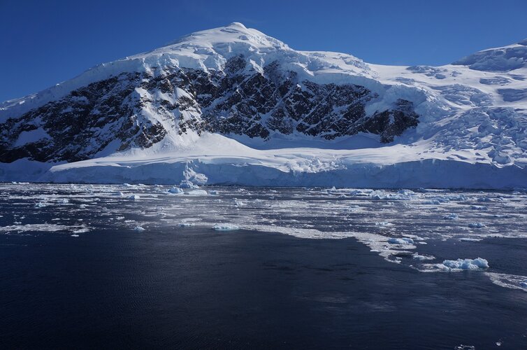
Satellite imagery has revealed that two of the fastest-changing glaciers in Antarctica are fracturing and weakening faster than ever – the first step towards the glaciers disintegrating and causing sea levels to rise dramatically.
Digital Twin Earth, quantum computing and AI take centre stage at ESA’s Φ-week
28.9.2020 12:00
ESA’s 2020 Φ-week event kicked off this morning with a series of stimulating speeches on Digital Twin Earth, updates on Φ-sat-1, which was successfully launched into orbit earlier this month, and an exciting new initiative involving quantum computing.
Watch Φ-week live
28.9.2020 8:35
At 09:30 today, ESA’s third edition of the Φ-week event will commence. Φ-week 2020 will be fully digital and will highlight innovation in Earth observation and showcase the latest achievements in Earth observation science, technology and applications.
Watch Φ-week live
28.9.2020 8:35
At 09:30 today, ESA’s third edition of the Φ-week event will commence. Φ-week 2020 will be fully digital and will highlight innovation in Earth observation and showcase the latest achievements in Earth observation science, technology and applications.
Copernicus sea-level satellite arrives safely in California
25.9.2020 17:30
The launch of the Copernicus Sentinel-6 Michael Freilich satellite – designed to measure the height of the ocean – is getting tantalisingly close. The satellite has now safely touched down at the Vandenberg Air Force Base in central California, where mission teams are busily preparing the satellite for its upcoming journey.
Earth from Space: Tarawa, Kiribati
25.9.2020 10:00 Video:
00:03:27
Video:
00:03:27
In this week's edition of the Earth from Space programme, Copernicus Sentinel-2 takes us over the Tarawa Atoll in the Republic of Kiribati – a remote Pacific nation threatened by rising seas.
See also Tarawa, Kiribati to download the image.
Tarawa, Kiribati
25.9.2020 10:00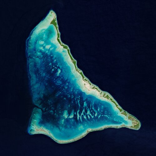 Image:
Copernicus Sentinel-2 takes us over the Tarawa Atoll in the Republic of Kiribati – a remote Pacific nation threatened by rising seas.
Image:
Copernicus Sentinel-2 takes us over the Tarawa Atoll in the Republic of Kiribati – a remote Pacific nation threatened by rising seas.
SEOSAT-Ingenio arrives in French Guiana
25.9.2020 9:30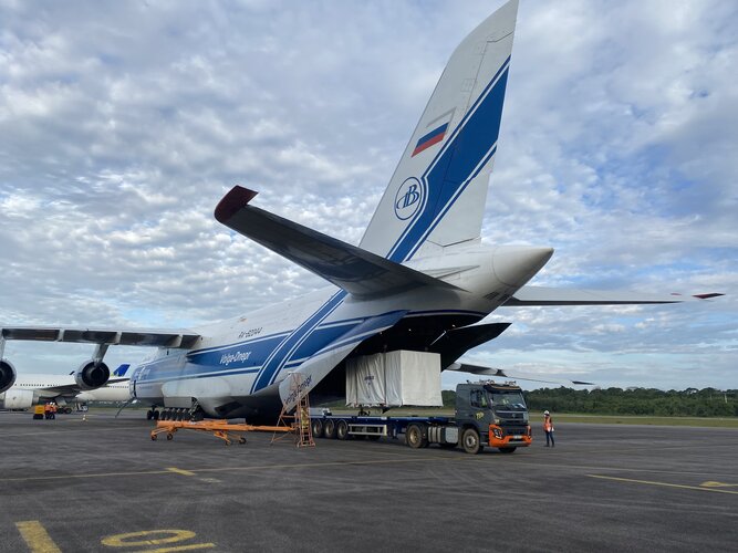
After leaving the Airbus premises in Madrid on 24 September, the Spanish high-resolution land imaging mission, known as SEOSAT-Ingenio, has arrived safely at Europe’s Spaceport in French Guiana, where it will be prepared for launch later this year.
Our seas are capturing more carbon than expected
22.9.2020 11:15
Earth’s oceans help to slow global warming by absorbing carbon from our atmosphere – but fully observing this crucial process in the upper ocean and lower atmosphere is difficult, as measurements are taken not where it occurs, the sea surface, but several metres below. New research uses data from ESA, NASA and NOAA satellites to rectify this, and finds that far more carbon is absorbed by the oceans than previously thought.
SEOSAT-Ingenio soon to be launched
22.9.2020 10:00 Video:
00:05:00
Video:
00:05:00
The Spanish high-resolution land imaging mission, known as SEOSAT-Ingenio, will soon be shipped from Airbus, in Madrid, to Europe’s Spaceport in French Guiana - where it will be prepared for launch later this year on a Vega rocket. The Earth-observing satellite carries a state-of-the-art dual camera that can image Earth’s land with a resolution of 2.5 m. The mission will benefit society through numerous disciplines such as cartography, agriculture, forestry, urban development and water management.
With its capability to look sideways, it can access any point on Earth within three days, and will be used to help map natural disasters such as floods, wildfires and earthquakes – as well as help with one of humankind’s biggest challenges: understanding and responding to climate change. While SEOSAT–Ingenio is a Spanish national mission, it is the result of an international collaborative effort. The mission is funded by Spain’s Centre for the Development of Industrial Technology (CDTI) of the Ministry of Science and Innovation, but developed by ESA in the context of the European Earth Observation Architecture.
Quifer app grabs top prize at 2020 Space App Camp
21.9.2020 17:30
An app that combines satellite data, big data and artificial intelligence in order to monitor the use of water resources has won the top prize at this year’s Space App Camp.
Plans underway for new polar ice and snow topography mission
21.9.2020 12:00
Monitoring the cryosphere is essential to fully assess, predict and adapt to climate variability and change. Given the importance of this fragile component of the Earth system, today ESA, along with Airbus Defence and Space and Thales Alenia Space, have signed a contract to develop the Copernicus Polar Ice and Snow Topography Altimeter mission, known as CRISTAL.
US West Coast on fire
18.9.2020 18:05
Over the past month, dozens of wildfires have burned vast swathes of land in California, Oregon and Washington State, killing more than 30 people and smothering the majority of the western United States in smoke. While photographs have circulated online showing the apocalyptic orange skies, satellites in orbit around Earth carry different instruments that can provide not only images, but a wealth of complementary information needed to monitor the blazes.
US West Coast on fire
18.9.2020 18:05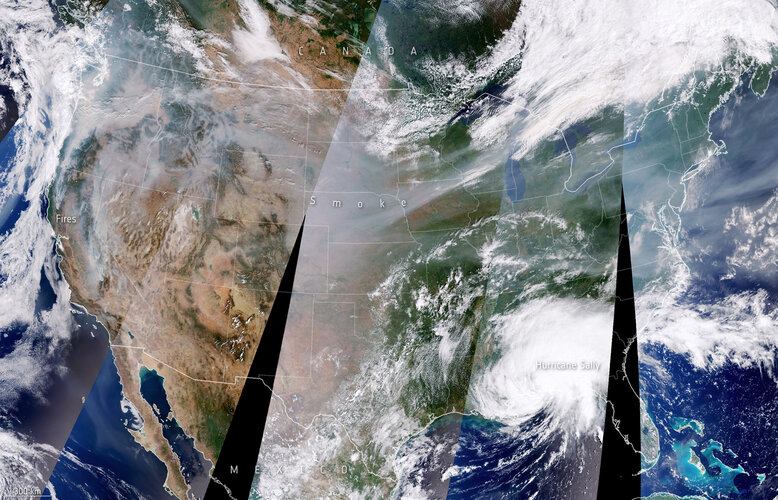
Over the past month, dozens of wildfires have burned vast swathes of land in California, Oregon and Washington State, killing more than 30 people and smothering the majority of the western United States in smoke. While photographs have circulated online showing the apocalyptic orange skies, satellites in orbit around Earth carry different instruments that can provide not only images, but a wealth of complementary information needed to monitor the blazes.
Air pollution in a post-COVID-19 world
18.9.2020 12:00
Air pollution is one of the biggest environmental problems of our time. According to a new report from the European Environment Agency (EEA), air pollution now accounts for one in eight deaths in Europe. Observations from the Copernicus Sentinel-5P satellite have been vital in tracking the evolution of air pollution, specifically nitrogen dioxide concentrations, across Europe.
Air pollution in a post-COVID-19 world
18.9.2020 12:00
Air pollution is one of the biggest environmental problems of our time. According to a new report from the European Environment Agency (EEA), air pollution now contributes to one in eight deaths in Europe. Observations from the Copernicus Sentinel-5P satellite have been vital in tracking the evolution of air pollution, specifically nitrogen dioxide concentrations, across Europe.
Earth from Space: Vatnajökull
18.9.2020 10:00 Video:
00:03:04
Video:
00:03:04
In this week's edition of the Earth from Space programme, the Copernicus Sentinel-2 mission takes us over the Vatnajökull ice cap, in southeast Iceland.
See also Vatnajökull, Iceland to download the image.
Vatnajökull, Iceland
18.9.2020 10:00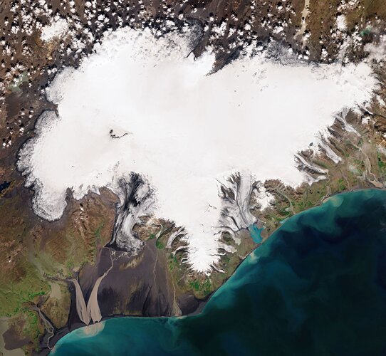 Image:
The Copernicus Sentinel-2 mission takes us over the Vatnajökull ice cap, in southeast Iceland.
Image:
The Copernicus Sentinel-2 mission takes us over the Vatnajökull ice cap, in southeast Iceland.
Medicane Ianos
18.9.2020 9:10 Image:
Copernicus Sentinel-3 captured this image of the Mediterranean hurricane, or ‘Medicane,’ crossing the Ionian Sea and approaching Greece yesterday 17 September.
Image:
Copernicus Sentinel-3 captured this image of the Mediterranean hurricane, or ‘Medicane,’ crossing the Ionian Sea and approaching Greece yesterday 17 September.
High-resolution methane emissions data for waste management
17.9.2020 11:00
Copernicus Sentinel-5P’s high revisit rate combined with GHGSat’s high-resolution commercial imagery can give landfill operators and regulators the information they need to reduce methane emissions from landfill sites.
Satellite data help climbers ascend Mount Everest
17.9.2020 9:40 Image:
Satellite data help climbers ascend Mount Everest
Image:
Satellite data help climbers ascend Mount Everest
Providing the facts to help Europe achieve 55%
16.9.2020 14:48
Today, at her State of the Union address before the European Parliament, Ursula von der Leyen, President of the European Commission, proposed a new target of a 55% cut in greenhouse gas emissions by 2030, compared to 1990 levels. The current target is a 40% reduction. With such ambitious goals ahead for Europe, understanding how greenhouse gases end up in the atmosphere and the intricacies of the carbon cycle is essential – something that satellites observing Earth can help provide.
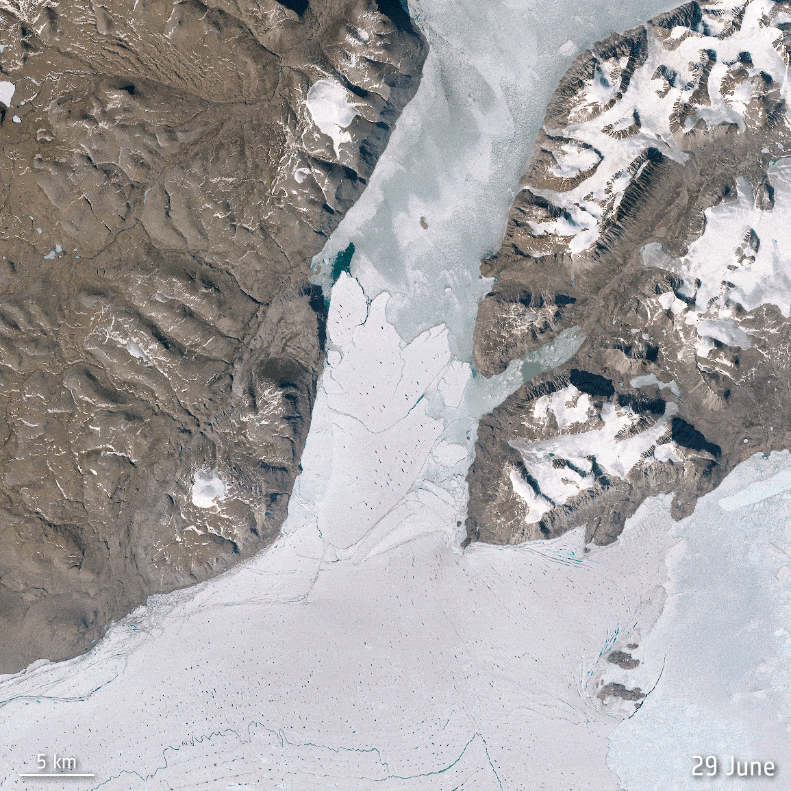 Image:
Spalte break up
Image:
Spalte break up
West coast wildfires
11.9.2020 15:13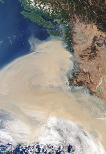 Image:
Captured on 10 September 2020, this Copernicus Sentinel-3 image shows thick smoke blanketing the US west coast.
Image:
Captured on 10 September 2020, this Copernicus Sentinel-3 image shows thick smoke blanketing the US west coast.
Amazon River
11.9.2020 10:00 Image:
This image, captured by Copernicus Sentinel-1, shows the Amazon River meandering through one of the most vital ecosystems in the world – the Amazon rainforest in South America.
Image:
This image, captured by Copernicus Sentinel-1, shows the Amazon River meandering through one of the most vital ecosystems in the world – the Amazon rainforest in South America.
Earth from Space: Amazon River
11.9.2020 10:00 Video:
00:03:00
Video:
00:03:00
This week's edition of Earth from Space features a Copernicus Sentinel-1 image of the Amazon River meandering through one of the most vital ecosystems in the world – the Amazon rainforest in South America.
See also Amazon River to download the image.
MOSAiC Arctic expedition reaches North Pole
9.9.2020 13:35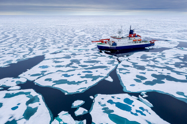
On 19 August 2020, the world’s largest and longest polar research expedition – known as MOSAiC – reached the North Pole after making an unplanned detour owing to lighter-than-usual sea ice conditions. The expedition is now entering its final stage, during which researchers will study the last piece of the Arctic puzzle: the growth of new sea ice marking the end of the summer season.
Ice sheet melt on track with ‘worst-case climate scenario’
8.9.2020 8:40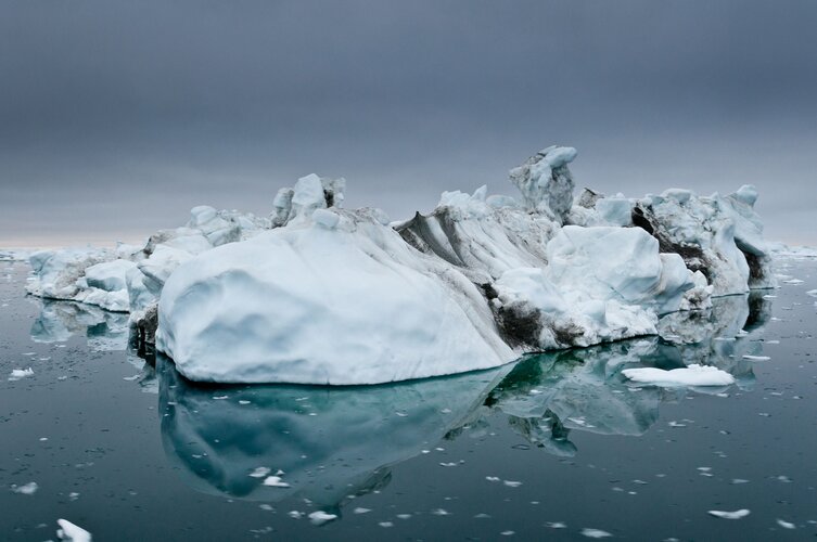
A recent report confirms that ice sheets in Greenland and Antarctica, whose mass-loss rates have been rapidly increasing, are matching the Intergovernmental Panel on Climate Change's worst-case sea-level rise scenarios.
Ice sheet melt on track with ‘worst-case climate scenario’
8.9.2020 8:40
A recent report confirms that ice sheets in Greenland and Antarctica, whose mass-loss rates have been rapidly increasing, are matching the Intergovernmental Panel on Climate Change's worst-case sea-level rise scenarios.
Register for ESA’s Φ-Week event
7.9.2020 14:00 Image:
ESA is pleased to invite you to participate in its third edition of the Φ-Week event
Image:
ESA is pleased to invite you to participate in its third edition of the Φ-Week event
Next artificial intelligence mission selected
4.9.2020 12:10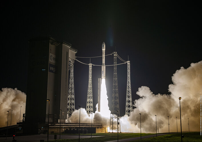
Following yesterday’s successful launch of ɸ-sat-1 – Europe’s first artificial intelligence Earth observation mission – plans are already underway for the next innovative state-of-the-art technology, ɸ-sat-2.
Next artificial intelligence mission selected
4.9.2020 12:10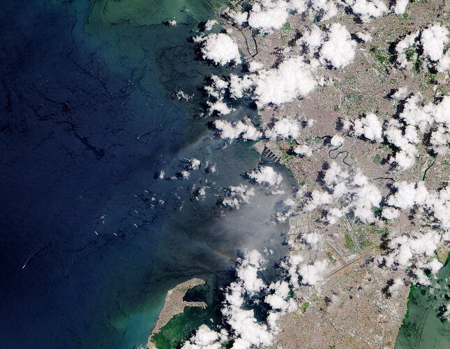
Following yesterday’s successful launch of ɸ-sat-1 – Europe’s first artificial intelligence Earth observation mission – plans are already underway for the next innovative state-of-the-art technology, ɸ-sat-2.
Gulf of Kutch, India
4.9.2020 10:00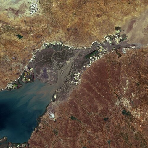 Image:
The Copernicus Sentinel-2 mission takes us over the Gulf of Kutch, an inlet of the Arabian Sea, along the west coast of India.
Image:
The Copernicus Sentinel-2 mission takes us over the Gulf of Kutch, an inlet of the Arabian Sea, along the west coast of India.
Earth from Space: Gulf of Kutch
4.9.2020 10:00 Video:
00:02:48
Video:
00:02:48
In this week's edition of the Earth from Space programme, the Copernicus Sentinel-2 mission takes us over the Gulf of Kutch, an inlet of the Arabian Sea, along the west coast of India.
See also Gulf of Kutch, India to upload the image.
Earth from Space: Gulf of Kutch
4.9.2020 10:00
Video:
00:02:48
In this week's edition of the Earth from Space programme, the Copernicus Sentinel-2 mission takes us over the Gulf of Kutch, an inlet of the Arabian Sea, along the west coast of India.
See also Gulf of Kutch, India to upload the image.
Vega return to flight proves new rideshare service
3.9.2020 6:35
The first flight of Vega’s rideshare service using the Small Spacecraft Mission Service (SSMS) dispenser for light satellites, launched from Europe’s Spaceport in Kourou, French Guiana at 02:51 BST / 03:51 CEST on 3 September (22:51 local time on 2 September).
Vega lifts off
3.9.2020 4:00 Video:
00:02:03
Video:
00:02:03
On 2 September 2020, Vega flight VV16 lifted off from Europe’s Spaceport in French Guiana to deliver 53 light satellites into two separate Sun-synchronous orbits demonstrating a new dispenser called the Small Spacecraft Mission Service, or SSMS.
Vega's SSMS rideshare missions will maximise the number of satellites on each launch thus lowering the cost per ridesharing customer. The SSMS can be used for a dedicated rideshare or to fit clusters of small satellites on the launch of a large satellite.
Excellence Award competition opens
1.9.2020 12:00
Do you know someone who is in the early stages of their career, but already deserves recognition for their innovative use of Earth observation? If so, there is now a unique opportunity to nominate them for the new ESA–EGU Earth Observation Excellence Award.
Watch Vega rideshare launch live
31.8.2020 9:00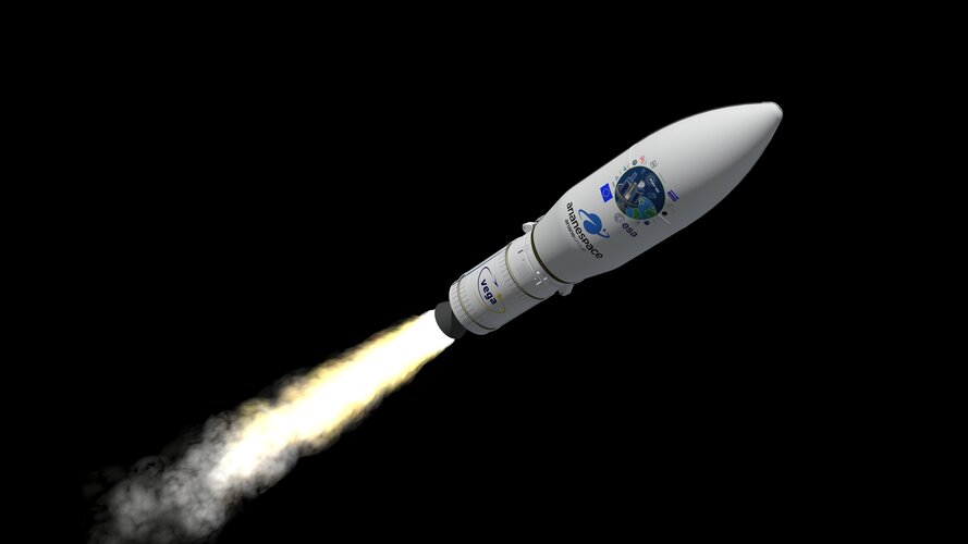
Tune in to ESA Web TV from 02:36 BST / 03:36 CEST on 2 September to watch the return to flight of Vega on its debut rideshare mission dedicated to light satellites.
Watch Vega rideshare launch live
31.8.2020 9:00
Update: launch postponed, check here for updates
The storm track of Typhoon Maysak over South Korea – which requires that the Jeju telemetry station be protected – has led to the postponement of final preparatory operations for Vega’s Flight VV16 launch, which was scheduled for 1 September (Kourou) / 2 September (03:51 CEST).
A new launch date will be set based on the evolution of the tropical storm’s situation over the Jeju station and its consequences.
The Vega launch vehicle and its 53 satellite payloads are in stable and fully safe conditions.
Watch Vega rideshare launch live
31.8.2020 9:00
Update: The countdown for launch has resumed. Liftoff is scheduled for 3 September 02:51 BST / 03:51 CEST (22:51 local time in Kourou on 2 September). The weather will be monitored constantly until the precise moment of liftoff to determine whether or not to authorise the launch.
The Vega launch vehicle and its 53 satellite payloads are in stable and fully safe conditions.
Cloud-free Iceland
28.8.2020 10:00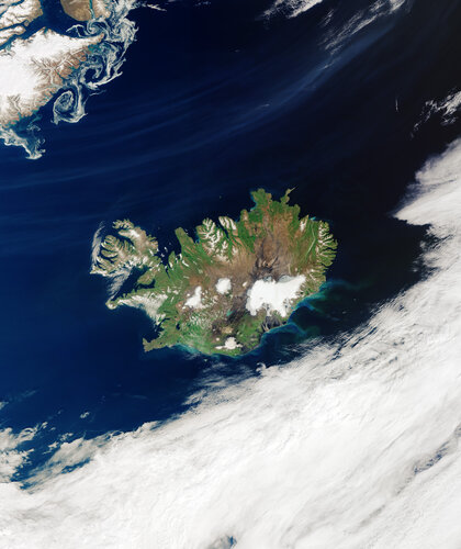 Image:
A rare, cloud-free view of Iceland is visible in this image captured by the Copernicus Sentinel-3 mission on 14 August 2020.
Image:
A rare, cloud-free view of Iceland is visible in this image captured by the Copernicus Sentinel-3 mission on 14 August 2020.
Monitoring the Arctic heatwave
27.8.2020 12:00
Over the past months, the Arctic has experienced alarmingly high temperatures, extreme wildfires and a significant loss of sea ice. While hot summer weather is not uncommon in the Arctic, the region is warming at two to three times the global average – impacting nature and humanity on a global scale. Observations from space offer a unique opportunity to understand the changes occurring in this remote region.
Monitoring the Arctic heatwave
27.8.2020 12:00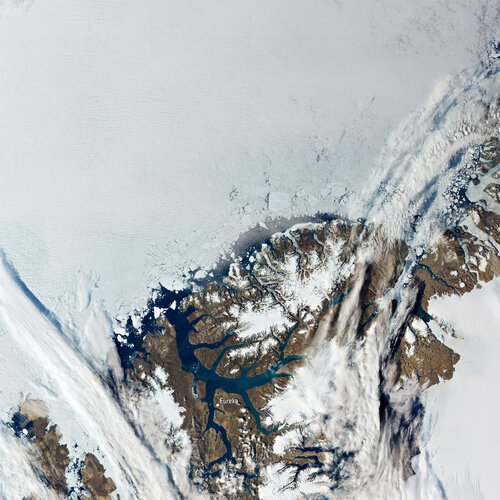
Over the past months, the Arctic has experienced alarmingly high temperatures, extreme wildfires and a significant loss of sea ice. While hot summer weather is not uncommon in the Arctic, the region is warming at two to three times the global average – impacting nature and humanity on a global scale. Observations from space offer a unique opportunity to understand the changes occurring in this remote region.
California on fire
20.8.2020 12:35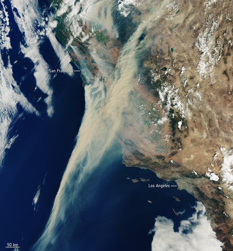 Image:
Captured on 19 August 2020, this Copernicus Sentinel-3 image shows the extent of the smoke from fires currently ablaze in California, US.
Image:
Captured on 19 August 2020, this Copernicus Sentinel-3 image shows the extent of the smoke from fires currently ablaze in California, US.
Vega launch now set for 1 September
17.8.2020 17:55
A new launch date of 1 September 2020 has been announced by Arianespace for Vega flight VV16.
Vega launch now set for 1 September
17.8.2020 17:55
Vega will return to flight on its debut rideshare mission dedicated to light satellites with liftoff at 02:51 BST / 03:51 CEST on 2 September (22:51 local time on 1 September).
Vega launch set for 1 September
17.8.2020 17:55
Vega will return to flight on its debut rideshare mission dedicated to light satellites with liftoff at 02:51 BST / 03:51 CEST on 2 September (22:51 local time on 1 September).
Mauritius oil spill
11.8.2020 17:45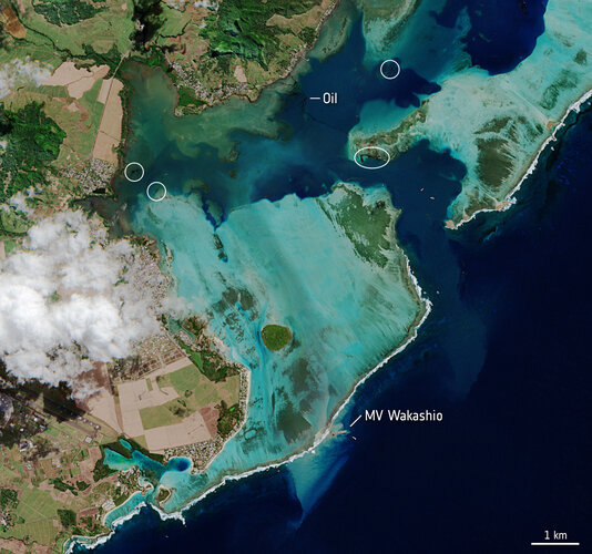 Image:
Satellite images are being used to monitor the oil spill off the coast of Mauritius.
Image:
Satellite images are being used to monitor the oil spill off the coast of Mauritius.
Europe’s next radar Sentinel unfolds
7.8.2020 9:30
In two years’ time, the next Copernicus Sentinel-1 satellite will be launched to join its two siblings in orbit around Earth. With engineers busy building Sentinel-1C, they have recently tested the mechanism that opens its 12 m-long radar antenna.
Satellites provide crucial data on crops during COVID-19
6.8.2020 12:00
Millions of people around the world face hunger every day, and unfortunately, the COVID-19 pandemic is expected to make the issue of food security even worse. Satellites are helping to alleviate the situation by providing crucial information to monitor crop growth and harvesting from space.
Discovering new penguin colonies from space
5.8.2020 8:00
Satellite images have revealed that there are nearly 20% more emperor penguin colonies in Antarctica than previously thought. Scientists, at the British Antarctic Survey, have used satellite data from the Copernicus Sentinel-2 mission to track penguin guano, or penguin poo, to monitor the presence of thousands of penguins.
CryoSat taken to new heights for ice science
3.8.2020 14:23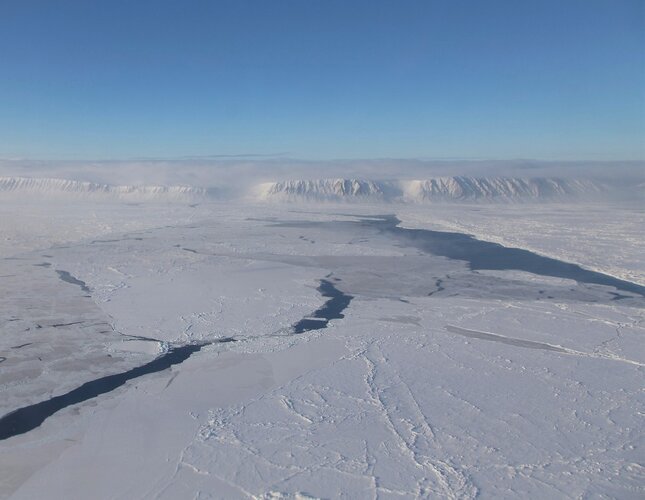
Ice plays a critical role in keeping Earth’s climate cool, but our rapidly warming world is taking its toll and ice is in general decline. For more than 10 years, ESA’s CryoSat has been returning critical information on how the height of our fragile ice fields is changing. Nevertheless, to gain even better insight, ESA has spent the last two weeks nudging CryoSat into a higher orbit to synchronise it with NASA’s ICESat-2 so that scientists can benefit from simultaneous measurements from different space sensors.
Contract signed to build Europe’s carbon dioxide monitoring mission
31.7.2020 10:56
With the amount of carbon dioxide in Earth’s atmosphere approaching levels that humans may have never before experienced, the need to monitor sources of emissions is more urgent than ever – hence the Copernicus Carbon Dioxide Monitoring mission being one of Europe’s new high-priority satellite missions. Taking the mission a significant step forward, ESA and OHB System AG have, today, signed a contract to build the first two satellites that make up the mission.
Flinders Ranges, South Australia
31.7.2020 10:00 Image:
The many colourful curves and folds of the Flinders Ranges in South Australia are featured in this false-colour image captured by the Copernicus Sentinel-2 mission.
Image:
The many colourful curves and folds of the Flinders Ranges in South Australia are featured in this false-colour image captured by the Copernicus Sentinel-2 mission.
Earth from Space: Flinders Ranges, South Australia
31.7.2020 10:00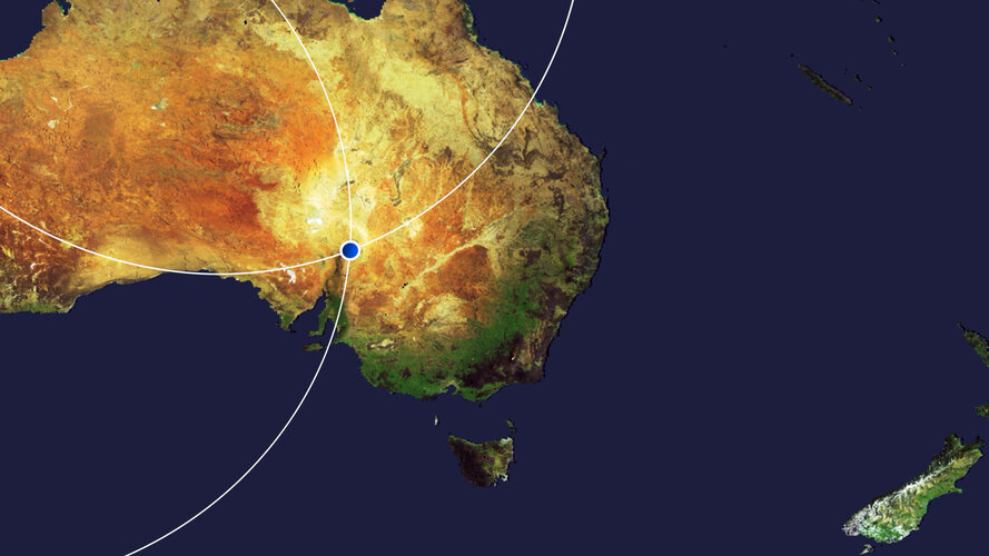 Video:
00:03:00
Video:
00:03:00
This edition of the Earth from Space programme features a false-colour image captured by Copernicus Sentinel-2 over the many colourful curves and folds of the Flinders Ranges – the largest mountain range in South Australia.
See also Flinders Ranges, South Australia to download the image.
New Space satellite pinpoints industrial methane emissions
29.7.2020 12:40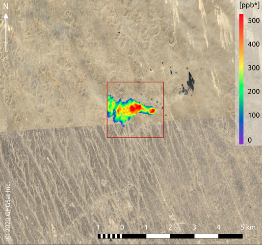
Methane may not be as abundant in the atmosphere as carbon dioxide, but with a global warming potential many times greater than carbon dioxide, monitoring and controlling industrial emissions of this potent gas is imperative to helping combat climate change. GHGSat is a New Space initiative that draws on Copernicus Sentinel-5P data for mapping methane hotspots – and its Claire satellite has now collected more than 60 000 methane measurements of industrial facilities around the world.
New Space satellite pinpoints industrial emissions of methane
29.7.2020 12:40
Methane may not be as abundant in the atmosphere as carbon dioxide, but with a global warming potential many times greater than carbon dioxide, monitoring and controlling industrial emissions of this potent gas is imperative to helping combat climate change. GHGSat is a New Space initiative that draws on Copernicus Sentinel-5P data for mapping methane hotspots – and its Claire satellite has now collected more than 60 000 methane measurements of industrial facilities around the world.
Earth from Space: Falkland Islands
24.7.2020 10:00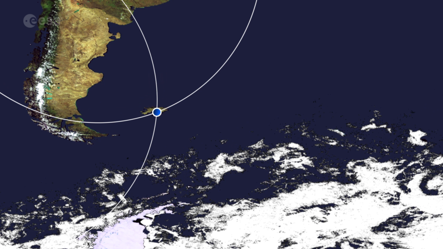 Video:
00:02:50
Video:
00:02:50
This week's edition of the Earth from Space programme features a radar image of the Falkland Islands, captured by the Copernicus Sentinel-1 mission.
See also Falkland Islands to download the image.
Falkland Islands
24.7.2020 10:00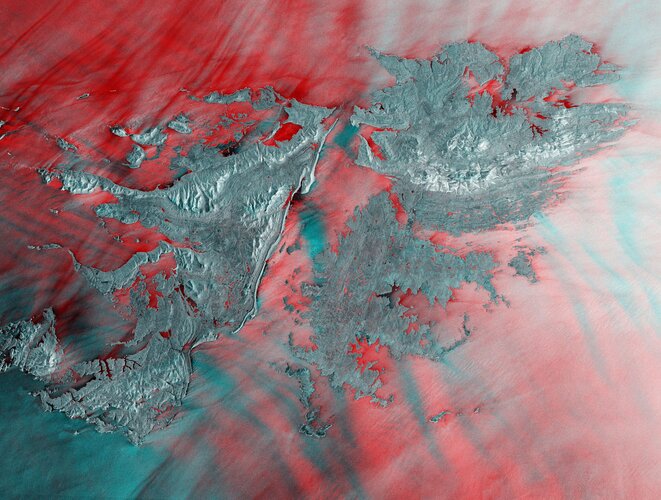 Image:
The Falkland Islands are featured in this radar image captured by the Copernicus Sentinel-1 mission.
Image:
The Falkland Islands are featured in this radar image captured by the Copernicus Sentinel-1 mission.
Mapping the Oaxaca earthquake from space
23.7.2020 9:30
On the morning of 23 June 2020, a strong earthquake struck the southern state of Oaxaca, Mexico. The 7.4- magnitude earthquake prompted evacuations in the region, triggered a tsunami warning and damaged thousands of houses. Satellite radar data, from the Copernicus Sentinel-1 mission, are being used to analyse the effects of the earthquake on land.
Sea-level charting satellite passes with flying colours
21.7.2020 16:10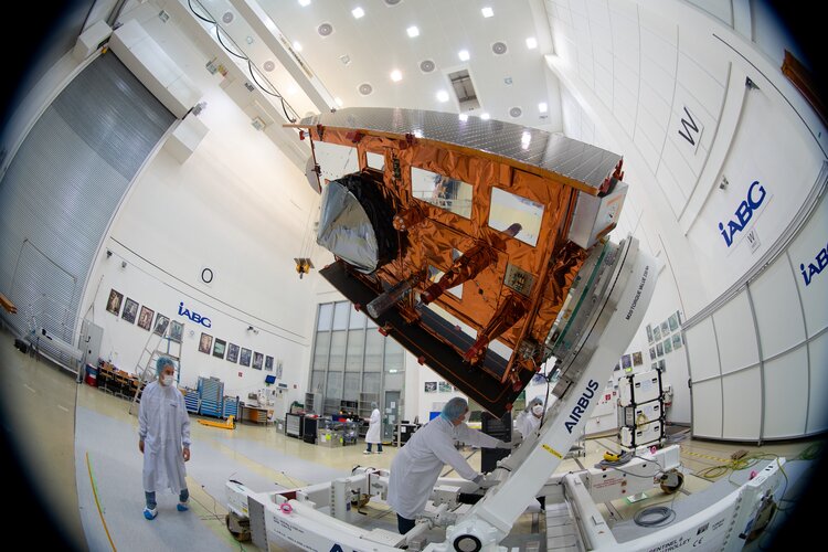
Like students all over the world currently awaiting exam grades, the Copernicus Sentinel-6 Michael Freilich satellite has also been put through a series of strenuous tests leaving the eyes of the teams involved in this international mission set firmly on its final results. Happily, Sentinel-6 has passed with flying colours and engineers can now prepare it for shipment to the US for liftoff on a SpaceX Falcon-9, which is scheduled for 10 November.
Earth from Space: Utah’s Great Salt Lake
17.7.2020 10:00 Video:
00:00:00
Video:
00:00:00
In this week's edition of Earth from Space, we explore Utah’s Great Salt Lake and its surroundings with Copernicus Sentinel-2
See also Utah’s Great Salt Lake to download the image.
Earth from Space: Utah’s Great Salt Lake
17.7.2020 10:00
Video:
00:03:30
In this week's edition of Earth from Space, we explore Utah’s Great Salt Lake and its surroundings with Copernicus Sentinel-2
See also Utah’s Great Salt Lake to download the image.
Utah's Great Salt Lake
17.7.2020 10:00 Image:
Utah’s Great Salt Lake and its surroundings are featured in this false-colour image captured by the Copernicus Sentinel-2 mission.
Image:
Utah’s Great Salt Lake and its surroundings are featured in this false-colour image captured by the Copernicus Sentinel-2 mission.
Giant A-68 iceberg three years on
10.7.2020 12:00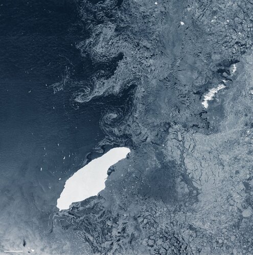
The colossus iceberg that split from Antarctica’s Larsen C ice shelf on 12 July 2017 is now in the open waters of the South Atlantic near the South Orkney Islands, about 1050 km from its birthplace. Having lost two chunks of ice, this record berg is a little less huge than it once was – and now that it is in rougher waters, it may break up further.
Bay of Naples, Italy
10.7.2020 10:00 Image:
The Copernicus Sentinel-1 mission takes us over the busy maritime traffic in the Bay of Naples, in southern Italy.
Image:
The Copernicus Sentinel-1 mission takes us over the busy maritime traffic in the Bay of Naples, in southern Italy.
Earth from Space: Bay of Naples
10.7.2020 10:00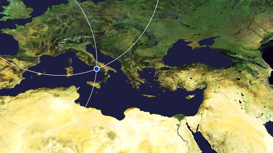 Video:
00:03:01
Video:
00:03:01
In this week's edition of the Earth from Space programme, the Copernicus Sentinel-1 mission takes us over the busy maritime traffic in the Bay of Naples, in southern Italy.
See also Bay of Naples, Italy to download the image.
Satellites track unusual Saharan dust plume
9.7.2020 13:05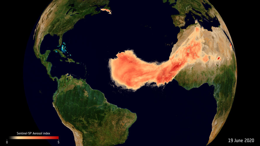
Every summer, the wind carries large amounts of desert dust particles from the hot and dry Sahara Desert in northern Africa across the Atlantic Ocean. Data from the Copernicus Sentinel satellites and ESA’s Aeolus satellite show the extent of this year’s summer dust plume, dubbed ‘Godzilla,’ on its journey across the Atlantic.
Join the second online Global Space Economic Workshop
7.7.2020 8:30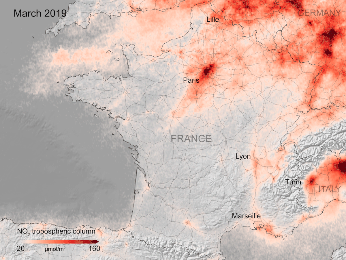
On 9 July at 9:30 BST / 10.30 CEST, join the second online Global Space Economic Workshop (GSEW) to discuss the value of Earth observation data during and after the COVID-19 crisis, how space data can help with monitoring the impacts of the pandemic and how this will assist the recovery in the post-COVID world.
Join the discussion on ESA web TV or ESA Space Economy.
Contracts awarded for development of six new Copernicus missions
3.7.2020 16:10
Following the financial commitment from ESA Member States at last November’s Council at Ministerial Level Space19+, ESA’s industrial policy committee has approved contracts totalling €2.55 billion to forward the development of six new Copernicus satellite missions, each mission comprising two satellites, a development and a recurrent unit.
Earth from Space: Ari Atoll, Maldives
3.7.2020 10:03 Video:
00:03:39
Video:
00:03:39
In this week's edition of the Earth from Space programme, we explore the Maldives with Copernicus Sentinel-2.
See also Ari Atoll, Maldives to download the image.
Earth from Space: Ari Atoll, Maldives
3.7.2020 10:03
Video:
00:03:39
In this week's edition of the Earth from Space programme, we explore the Maldives with Copernicus Sentinel-2.
See also Ari Atoll, Maldives to download the image.
Ari Atoll, Maldives
3.7.2020 10:00 Image:
The Maldives are featured in this image captured by the Copernicus Sentinel-2 mission.
Image:
The Maldives are featured in this image captured by the Copernicus Sentinel-2 mission.
Sulphur dioxide concentrations drop over India during COVID-19
1.7.2020 9:10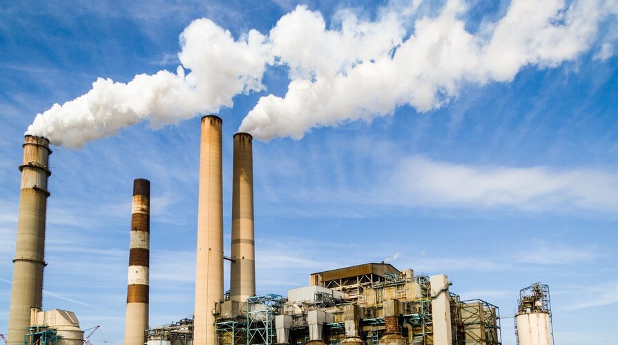
Concentrations of sulphur dioxide in polluted areas in India have decreased by around 40% between April 2019 and April 2020. Using data from the Copernicus Sentinel-5P satellite, from the European Union Copernicus programme, scientists have produced new maps which show the drop in concentrations across the country in times of COVID-19.
Space App Camp 2020 goes digital
30.6.2020 14:50
ESA invites App developers and specialists in artificial intelligence and machine learning to apply to take part in this year’s Space App Camp, which will be held on 11–21 September. Like many events now, the App Camp will take place online.
Space App Camp 2020 goes digital
30.6.2020 14:50
ESA invites App developers and specialists in artificial intelligence and machine learning to apply to take part in this year’s Space App Camp, which will be held on 11–21 September. Like many events now, the App Camp will take place online.
Roter Kamm impact crater
30.6.2020 10:00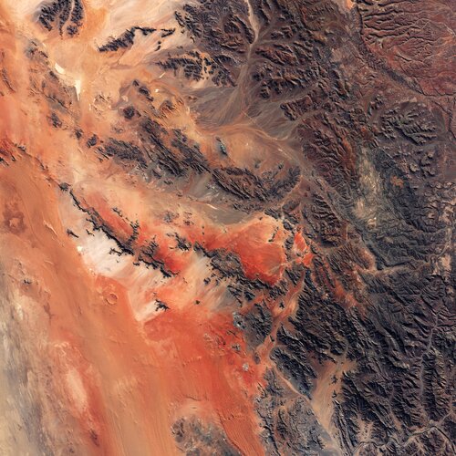 Image:
On Asteroid Day, the Copernicus Sentinel-2 mission takes us over the Roter Kamm impact crater in Namibia.
Image:
On Asteroid Day, the Copernicus Sentinel-2 mission takes us over the Roter Kamm impact crater in Namibia.
Roter Kamm impact crater
30.6.2020 10:00 Image:
On Asteroid Day, the Copernicus Sentinel-2 mission takes us over the Roter Kamm impact crater in Namibia.
Image:
On Asteroid Day, the Copernicus Sentinel-2 mission takes us over the Roter Kamm impact crater in Namibia.
Earth from Space: Peruvian Andes
26.6.2020 10:00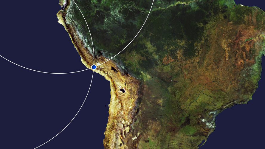 Video:
00:03:47
Video:
00:03:47
In this week's edition of the Earth from Space programme, the Andes mountains, in southern Peru, are featured in this false-colour image captured by the Copernicus Sentinel-2 mission
Peruvian Andes
26.6.2020 10:00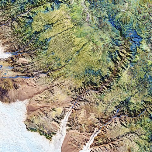 Image:
The Andes mountains, in southern Peru, are featured in this false-colour image captured by the Copernicus Sentinel-2 mission.
Image:
The Andes mountains, in southern Peru, are featured in this false-colour image captured by the Copernicus Sentinel-2 mission.
Peruvian Andes
26.6.2020 10:00 Image:
The Andes mountains, in southern Peru, are featured in this false-colour image captured by the Copernicus Sentinel-2 mission.
Image:
The Andes mountains, in southern Peru, are featured in this false-colour image captured by the Copernicus Sentinel-2 mission.
Earth from Space: Peruvian Andes
26.6.2020 10:00 Video:
00:03:47
Video:
00:03:47
In this week's edition of the Earth from Space programme, the Andes mountains, in southern Peru, are featured in this false-colour image captured by the Copernicus Sentinel-2 mission
Take part in citizen science for food security
26.6.2020 9:00
The International Institute for Applied System Analysis (IIASA) and ESA, in partnership with the Wilson Center, the Earth Day Network and the US State Department, are giving citizens the opportunity to get involved in one of the world’s most challenging problems: ensuring a nutritious food supply to meet the needs of the growing global population.
Space agencies join forces to produce global view of COVID-19 impacts
25.6.2020 14:00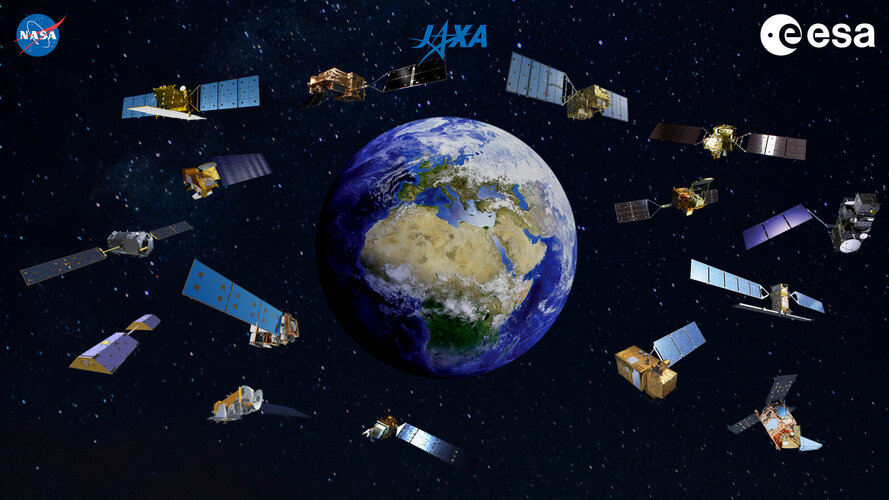
In an unprecedented collaboration, ESA, NASA and JAXA (Japan Aerospace Exploration Agency) have created a new tool that combines a wealth of data from Earth-observing satellites to monitor the worldwide impacts of COVID-19. This new online platform is now available to the public.
SMOS monitoring droughts
23.6.2020 16:19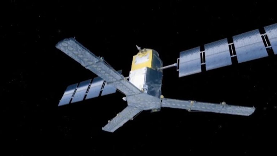 Video:
00:03:00
Video:
00:03:00
In orbit for more than a decade, ESA’s Earth Explorer satellite SMOS has not only exceeded its planned lifespan, but also surpassed its original scientific goals. Built to demonstrate new technology in space and address gaps in our scientific understanding of how Earth works as a system, this remarkable mission is now also being used for a number of practical applications. With drought seemingly more commonplace, entrepreneurs are using information on soil moisture from SMOS and data from other satellites to generate commercial data products for the insurance market, ultimately bringing benefits to farmers.
This video includes interviews of :
Klaus Scipal: SMOS Mission Manager, ESA, Soundbites in English & German
Thijs van Leeuwen: CEO of VanderSat – Soundbites in English & Dutch
Marcel Andriesse: Senior underwriter agri-culture Swiss Re - Soundbites in English & Dutch
Great Rift Valley, Kenya
19.6.2020 10:00 Image:
The Copernicus Sentinel-2 mission takes us over part of the Great Rift Valley, Kenya.
Image:
The Copernicus Sentinel-2 mission takes us over part of the Great Rift Valley, Kenya.
Earth from Space: Great Rift Valley, Kenya
19.6.2020 10:00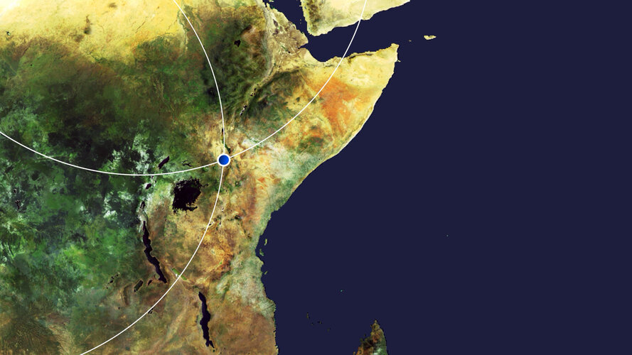 Video:
00:00:00
Video:
00:00:00
In this week's edition of the Earth from Space programme, the Copernicus Sentinel-2 mission takes us over part of the Great Rift Valley, Kenya.
See also Great Rift Valley, Kenya to download the image.
Call for Media: ESA, NASA and JAXA to unveil COVID-19 Earth Observation Dashboard
18.6.2020 14:50Press Release N° 10–2020
ESA, NASA and JAXA invite the general public and media representatives to participate in an online media conference on Thursday, 25 June, at 09:00 EDT (15:00 CEST) where they will present a new dashboard that uses Earth observation data to show the impacts of COVID-19. This new platform will combine data, technical knowledge and expertise of the three space agencies to strengthen our global understanding of the environmental and economic impacts of the COVID-19 pandemic.
Watch Vega's rideshare launch live
17.6.2020 17:45
Updated: Subject to favourable weather conditions, the soonest possible launch date for the SSMS proof-of-concept flight is Sunday 21 June from 02:36 BST / 03:36 CEST (20 June at 22:51 local time in Kourou).
Please check here for updates.
Watch Vega's rideshare launch live
17.6.2020 17:45
Update: Tune in tonight to ESA Web TV to watch the return to flight of Vega on its debut rideshare mission dedicated to light satellites.
Today’s predicted meteorological conditions over Europe's Spaceport enable the consideration of resuming chronological operations for the Vega Flight VV16 launch. Subject to confirmation of favourable conditions, the new targeted liftoff is Sunday, 28 June at 02:51 BST / 03:51 CEST (22:51 on 27 June Kourou local time).
The Vega launch vehicle and its 53 spacecraft payloads are in stable and safe conditions.
Watch Vega's rideshare launch live
17.6.2020 17:45
Update: As high-altitude winds above Europe's Spaceport remain unfavourable, Arianespace has taken the decision not to initiate the final chronology operations for Flight VV16 on Sunday 20 June (19 June in Kourou).
A new target date will be announced as soon as possible, based on the evolution of weather conditions.
The Vega launch vehicle and its 53 spacecraft payloads are in stable and safe conditions.
Please check here for updates.
Watch Vega's rideshare launch live
17.6.2020 17:45
Update: Arianespace has taken the decision to initiate the final chronology operations for flight VV16 on Sunday, 29 June at 02:51 BST / 03:51 CEST (22:51 on 28 June Kourou local time). This is subject to a favourable evolution of the weather conditions.
The Vega launch vehicle and its 53 spacecraft payloads are in stable and safe conditions.
Tune in to ESA Web TV to watch the return to flight of Vega on its debut rideshare mission dedicated to light satellites.
Watch Vega's rideshare launch live
17.6.2020 17:45
Update: Arianespace has taken the decision to initiate the final chronology operations for flight VV16 on Monday, 29 June at 02:51 BST / 03:51 CEST (22:51 on 28 June Kourou local time). This is subject to a favourable evolution of the weather conditions.
The Vega launch vehicle and its 53 spacecraft payloads are in stable and safe conditions.
Tune in to ESA Web TV to watch the return to flight of Vega on its debut rideshare mission dedicated to light satellites.
Vega launch postponed
17.6.2020 17:45
Update: Arianespace has decided to postpone Vega flight VV16 due to unfavourable weather. A new launch date is to be announced. More information will be available soon.
The Vega launch vehicle and its 53 spacecraft payloads remain stable and in total safety.
Vega launch postponed
17.6.2020 17:45
Update: Arianespace has decided to postpone Vega flight VV16 due to unfavourable weather. A new launch date is to be announced. More information will be available soon.
The Vega launch vehicle and its 53 spacecraft payloads remain stable and in total safety.
Watch Vega's rideshare launch live
17.6.2020 17:45
Updated: New launch date due to unfavourable weather at altitude above Europe's Spaceport.
Tune in to ESA Web TV on Sunday 21 June from 02:36 BST / 03:36 CEST to watch the return to flight of Vega on its debut rideshare mission dedicated to light satellites.
Vega will lift off from Europe's Spaceport in French Guiana carrying 53 satellites on its new dispenser called the Small Spacecraft Mission Service, or SSMS.
Vega launch postponed until 17 August
17.6.2020 17:45
A new launch date of 17 August 2020 has been announced by Arianespace for Vega flight VV16.
Tonight! Watch Vega's rideshare launch live
17.6.2020 17:45
Update: Tune in tonight to ESA Web TV to watch the return to flight of Vega on its debut rideshare mission dedicated to light satellites.
Today’s predicted meteorological conditions over Europe's Spaceport enable the consideration of resuming chronological operations for the Vega Flight VV16 launch. Subject to confirmation of favourable conditions, the new targeted liftoff is Sunday, 28 June at 02:51 BST / 03:51 CEST (22:51 on 27 June Kourou local time).
The Vega launch vehicle and its 53 spacecraft payloads are in stable and safe conditions.