


ESA Observing the Earth 
zdroje zpráv:
ESA’s Biomass on track to target forests
15.11.2021 15:20
With more than 100 global leaders at COP26 having pledged to halt and reverse deforestation and land degradation by the end of the decade to help address the climate crisis, the health of the world’s forests is high on the political agenda. ESA’s Biomass mission will soon play a key role in delivering novel information about the of the state of our forests, how they are changing over time, and advance our knowledge of the carbon cycle. With launch scheduled for 2023, the mission is now in its last phases of development, having recently passed several key milestones.
ESA’s Biomass on track to target forests
15.11.2021 15:20
With more than 100 global leaders at COP26 having pledged to halt and reverse deforestation and land degradation by the end of the decade to help address the climate crisis, the health of the world’s forests is high on the political agenda. ESA’s Biomass mission will soon play a key role in delivering novel information about the state of our forests, how they are changing over time, and advance our knowledge of the carbon cycle. With launch scheduled for 2023, the mission is now in its last phases of development, having recently passed several key milestones.
ESA uses space to supercharge climate action
15.11.2021 12:43
ESA is primed to play a crucial role in the revitalised international drive to combat global warming set out at the COP26 climate talks.
Earth from Space: Cancún, Mexico
12.11.2021 10:00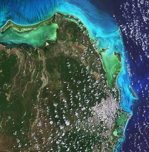
Cancún, situated in Quintana Roo on the northeast coast of Mexico’s Yucatán Peninsula, is featured in this image captured by the Copernicus Sentinel-2 mission.
Earth from Space: Cancún, Mexico
12.11.2021 10:00
Cancún, situated in Quintana Roo on the northeast coast of Mexico’s Yucatán Peninsula, is featured in this image captured by the Copernicus Sentinel-2 mission.
Mapping our human footprint from space
11.11.2021 14:05
The world’s population is expected to reach 9.7 billion in 2050, according to the UN Department of Economics and Social Affairs. Urban areas are already home to 55% of the world’s population and that figure is expected to grow to 68% by 2050. Rapid and unplanned urbanisation, combined with the challenges brought by climate change, can lead to an increase in air pollution, higher vulnerability to disasters, as well as issues related to the management of resources such as water, raw materials and energy.
To improve the understanding of current trends in global urbanisation, ESA and the German Aerospace Center (DLR), in collaboration with the Google Earth Engine team, are jointly developing the World Settlement Footprint – the world’s most comprehensive dataset on human settlement.
Tuning in to Earth’s climate
11.11.2021 10:00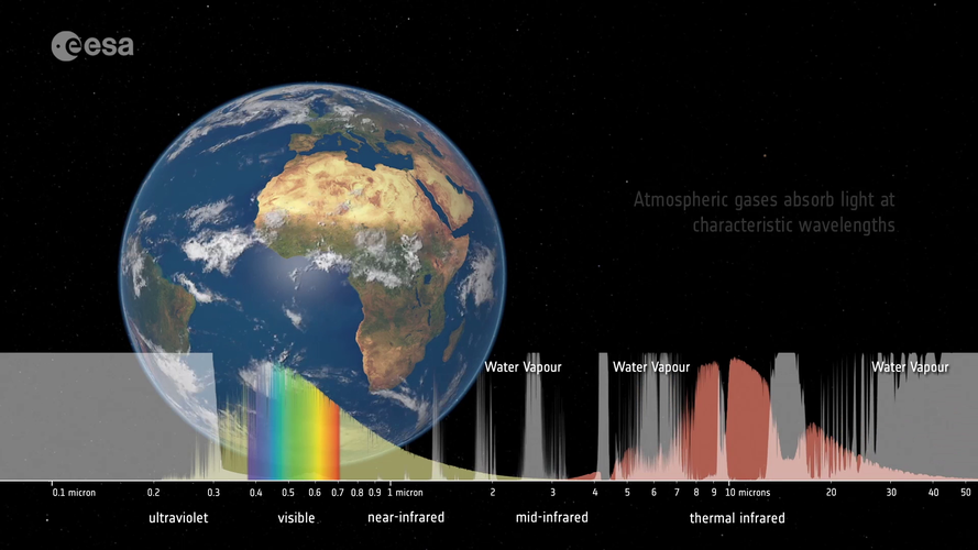 Video:
00:03:28
Video:
00:03:28
Satellites observe the Earth using a range of wavelengths on the electromagnetic spectrum. Different wavelengths allow us to probe different aspects of Earth’s land, atmosphere and ocean. By sampling the electromagnetic spectrum at multiple wavelengths, we can build a more complete picture of Earth’s complex climate system.
Carbon dioxide monitoring satellite given the shakes
10.11.2021 15:25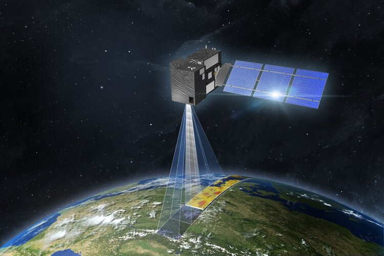
A new satellite destined to be Europe’s prime mission for monitoring and tracking carbon dioxide emissions from human activity is being put through its paces at ESA’s Test Centre in the Netherlands. With nations at COP26 pledging net-zero emissions by 2050, the pressure is on to reduce the amount of greenhouse gases we pump into the atmosphere – but the race is also on to support the monitoring that shows targets are being met. ESA, the European Commission, Eumetsat and industrial partners are therefore working extremely hard to get the Copernicus Anthropogenic Carbon Dioxide Monitoring mission ready for liftoff in 2025.
Satellites detect large methane emissions from Madrid landfills
10.11.2021 9:30
High-resolution satellites have detected substantial quantities of methane leaking from adjacent landfill sites close to the centre of Madrid, Spain. Using data from the Copernicus Sentinel-5P mission combined with GHGSat’s high-resolution commercial imagery, scientists from the SRON Netherlands Institute for Space Research and GHGSat discovered both landfill sites combined emitted 8800 kg of methane per hour in August 2021 – the highest observed in Europe by GHGSat.
Satellites pinpoint communities at risk of permafrost thaw
9.11.2021 9:30
Thawing permafrost in the Arctic is already unleashing methane and carbon dioxide to the atmosphere, exacerbating global temperature rise. As well adding to the climate crisis, this ground, which has been frozen for thousands of years, is becoming unstable and causing serious issues for local communities. For the first time, data from the Copernicus Sentinel-1 and Sentinel-2 missions along with artificial intelligence have been used to offer a complete overview of the Arctic to identify communities and infrastructure that will be at risk over the next 30 years.
Earth from Space: Shetland Islands
5.11.2021 10:00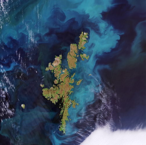
The Shetland Islands, an archipelago in the Northern Isles of Scotland, are featured in this Copernicus Sentinel-2 image.
Earth from Space: Shetland Islands
5.11.2021 10:00
The Shetland Islands, an archipelago in the Northern Isles of Scotland, are featured in this Copernicus Sentinel-2 image.
Melt
4.11.2021 15:00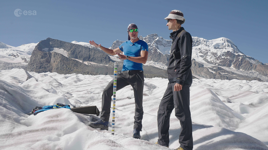 Video:
00:31:09
Video:
00:31:09
Glaciers across the globe have lost over nine trillion tonnes of ice in half a century. How will glaciers look over the coming decades? “It all depends on what humans are doing now in terms of greenhouse gas emissions:” this is the message one scientist delivered during an ESA-led expedition to the Gorner Glacier in Switzerland – one of the biggest ice masses in the Alps.
As world leaders gather for the 26th UN Climate Change Conference of Parties, watch the exclusive premiere of the documentary that follows ESA astronaut Luca Parmitano, along with a team of glaciologists and climate experts, on their journey across the Alps to learn how rising global temperatures are taking their toll on glaciers.
The documentary features breathtaking scenery of the Gorner Glacier as well as interviews with climate specialists as they explain how we can monitor glaciers using both satellite data and in situ measurements.
The documentary features interviews with:
Luca Parmitano, ESA astronaut
Simonetta Cheli, Head of Strategy, Programme & Coordination Office, Directorate of Earth Observation Programmes, ESA (as of 1 January 2022: ESA Director of Earth Observation Programmes)
Susanne Mecklenburg, Head of ESA’s Climate Office
Anna Maria Trofaier, Cryosphere scientist, ESA Climate Office
Frank Paul, Senior Researcher at the University of Zurich
Alessio Romeo, Geologist at La Venta – Esplorazioni Geografiche
Daniel Farinotti, Glaciologist at ETH Zurich
Explore ESA’s interactive Climate Change Kit
4.11.2021 10:10
Arguably, humankind has never been more aware of the jeopardy we and the planet face because of climate change. As world leaders at COP26 work to accelerate action towards reducing greenhouse gas emissions to keep the goal of 1.5°C temperature rise within reach, we bring you a new easy-to-use guide on what ESA is doing to understand and monitor climate change from space – data that are essential for policy-makers.
TRUTHS shapes up
3.11.2021 16:00
ESA’s new TRUTHS mission is taking shape. Highlighted today at COP26, this new mission is moving from its feasibility phase into its preliminary design phase. TRUTHS is set to provide measurements of incoming solar radiation and of radiation reflected from Earth back out into space as traceable International System of Units. These measurements will allow changes in Earth’s climate to be detected faster, and they will be used to calibrate data from other satellites. In effect, TRUTHS will be a ‘standards laboratory in space’, setting the ‘gold standard’ for climate measurements.
ESA and GHGSat support new International Methane Emissions Observatory
3.11.2021 12:32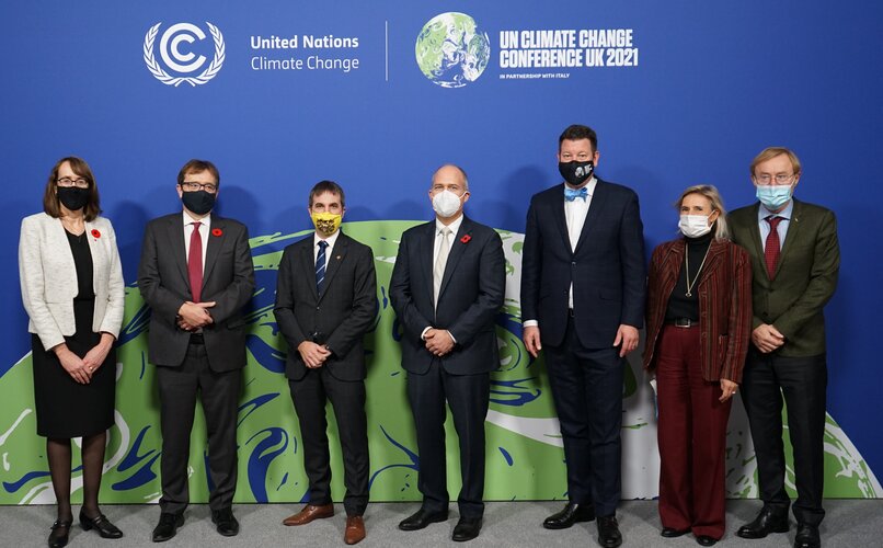
In the first 20 years of reaching the atmosphere, methane has more than 80 times the warming power of carbon dioxide. Reducing emissions of this extremely potent gas is, therefore, one of the fastest ways of slowing the rate of global warming, at least in the short term – and at COP26, more than 100 countries have just signed up to the Global Methane Pledge, which aims to limit emissions by 30% compared with 2020 levels.
With both public and commercial satellite data playing key roles in assessing progress on climate action, ESA and GHGSat are supporting the United Nations Environment Programme’s new International Methane Emissions Observatory, also announced at COP26.
Meltwater runoff from Greenland becoming more erratic
3.11.2021 10:16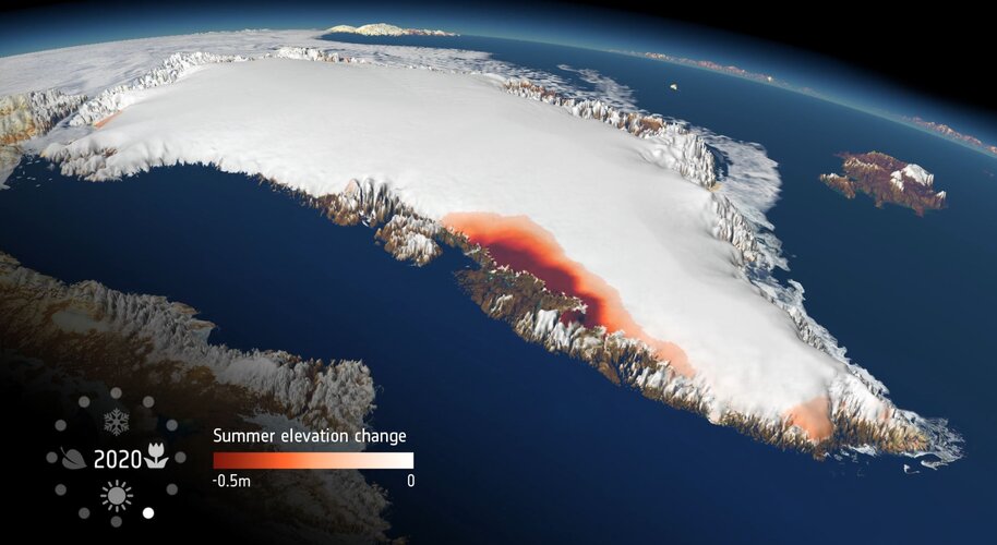
As world leaders and decision-makers join forces at COP26 to accelerate action towards the goals of the Paris Agreement, new research, again, highlights the value of satellite data in understanding and monitoring climate change. This particular new research, which is based on measurements from ESA’s CryoSat mission, shows that extreme ice melting events in Greenland have become more frequent and more intense over the past 40 years, raising sea levels and the risk of flooding worldwide.
Space for a Green Future
2.11.2021 15:06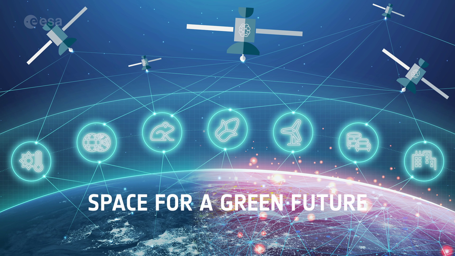 Video:
00:02:12
Video:
00:02:12
The climate crisis is the most urgent challenge faced by humankind – affecting every region, continent, and ocean on Earth. Space has an untapped potential to make a difference in tackling the threats and challenges faced by humanity. Satellites watch over Earth continuously, helping us to monitor, understand, model, predict and act on climate change and its related challenges.
As part of one of the three ‘Accelerators’ that will drive Europe’s increased use of space, the Space for a Green Future Accelerator will help Europe act to mitigate climate change. It will provide actionable information, helping form the baseline for effective European adaptation strategies to support the green transition, enabling the European Union to reach its goal of becoming carbon neutral by 2050, and supporting its Green Deal. Learn more about how ESA will bring Europe’s space ambitions to the next level by clicking here.
Change in the Arctic
2.11.2021 10:00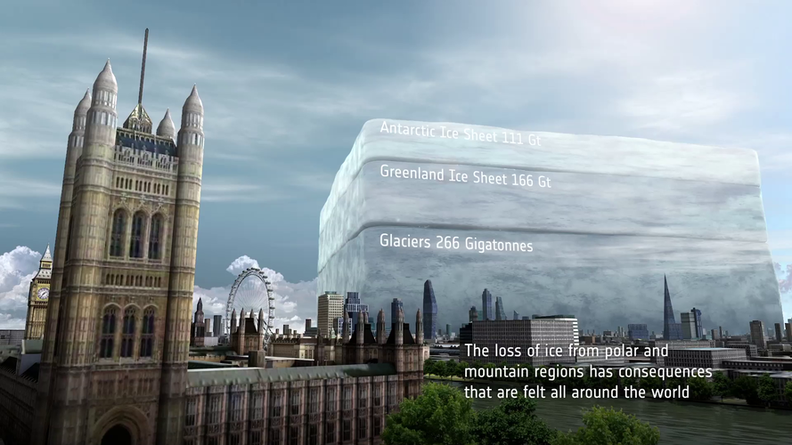 Video:
00:03:17
Video:
00:03:17
Satellites play a vital role in monitoring the rapid changes taking place in the Arctic. Tracking ice lost from the world’s glaciers, ice sheets and frozen land shows that Earth is losing ice at an accelerating rate. Currently more than a trillion tonnes of ice is lost each year. The sooner Earth’s temperature is stabilised, the more manageable the impacts of ice loss will be.
ESA accelerates space-based climate action at COP26
1.11.2021 9:00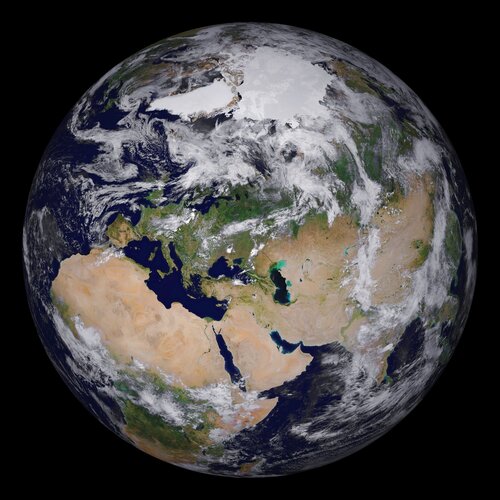
ESA is poised to showcase how satellite data underpins global efforts to avert climate catastrophe at pivotal international talks held in the UK.
Antarctic glacier named Glasgow to mark COP26
31.10.2021 14:30
Nine fast-flowing glaciers in West Antarctica have been named after locations of important climate treaties, conferences and reports. One of the glaciers is now called Glasgow Glacier to mark the city hosting the COP26 climate change conference. All the glaciers are in the Getz region, which, using data from satellites, was found recently to have lost more than 300 gigatonnes of ice over the last 25 years.
Earth from Space: Glasgow
29.10.2021 10:00
Glasgow, host of the 26th UN Climate Change Conference of Parties (COP26), is featured in this image captured by the Copernicus Sentinel-2 mission.
ESA and NASA launch revolutionary open-source platform
29.10.2021 9:00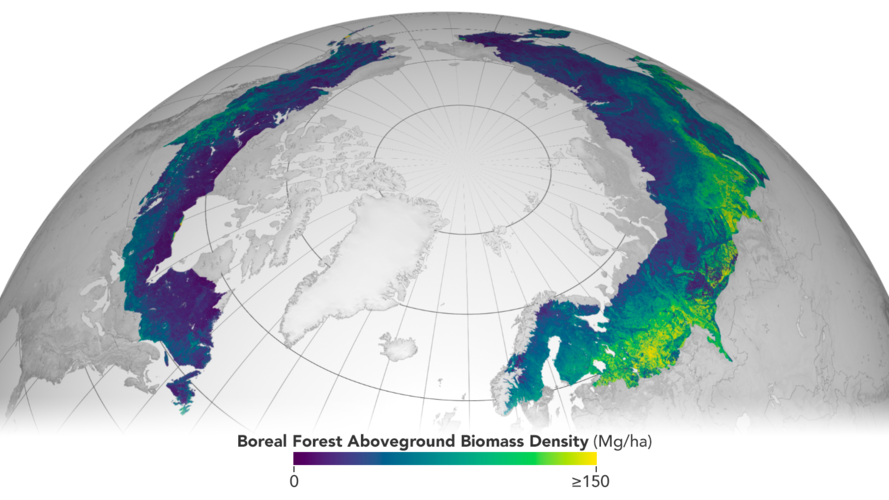
Today, ESA and NASA have publicly released the first globally-harmonised assessment of above ground biomass – information that is vital for managing global climate change. The Multi-Mission Algorithm and Analysis Platform (MAAP) provides seamless access to above ground biomass information from both NASA and ESA Earth observation data. The revolutionary open-science tool is now fully operational and accessible online.
Permafrost thaw could release bacteria and viruses
22.10.2021 13:47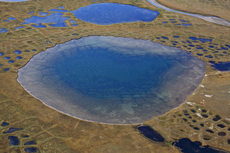
When considering the implications of thawing permafrost, our initial worries are likely to turn to the major issue of methane being released into the atmosphere and exacerbating global warming or issues for local communities as the ground and infrastructure become unstable. While this is bad enough, new research reveals that the potential effects of permafrost thaw could also pose serious health threats.
As part of the ESA–NASA Arctic Methane and Permafrost Challenge, new research has revealed that rapidly thawing permafrost in the Arctic has the potential to release antibiotic-resistant bacteria, undiscovered viruses and even radioactive waste from Cold War nuclear reactors and submarines.
Earth from Space: Perth, Australia
22.10.2021 10:00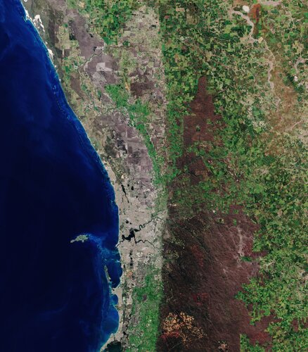
Perth, Western Australia’s capital and largest city, is featured in this true-colour image captured by the Copernicus Sentinel-2 mission.
ESA moves forward with Destination Earth
21.10.2021 15:45
Earth observation provides a wealth of information to benefit our daily lives. As the demand for satellite data grows to address the challenges of climate change and a growing population, ESA, under the leadership of the European Commission, along with its key European partners, are developing digital replicas of Earth to monitor and simulate both natural and human activity, to enable more sustainable development and support European environmental policies.
Today, at the ESA Council, Member States approved a ‘Contribution Agreement', which paves the way for cooperation with the European Commission on the Destination Earth programme – in the context of the Digital Agenda of the European Union.
ESA moves forward with Destination Earth
21.10.2021 15:45
Earth observation provides a wealth of information to benefit our daily lives. As the demand for satellite data grows to address the challenges of climate change and a growing population, ESA, under the leadership of the European Commission, along with its key European partners, are developing high precision digital models of Earth to monitor and simulate both natural and human activity, to enable more sustainable development and support European environmental policies.
Today, at the ESA Council, Member States approved a ‘Contribution Agreement', which paves the way for cooperation with the European Commission on the Destination Earth initiative, in the context of the Digital Agenda of the European Union.
Three new Directors join the European Space Agency’s Executive Board
21.10.2021 10:50
As of today, ESA has appointed three new Directors - for Commercialisation, Industry and Procurement, Earth Observation Programmes and Navigation. The new Directors were appointed by ESA Council at its meeting on 21 October; they will support the Director General with responsibility for activities and overall objectives in their respective directorates.
Living Planet Symposium 2022: time for abstracts
21.10.2021 9:05
ESA’s next Living Planet Symposium is set to take place on 23–27 May 2022 in Bonn, Germany. In gearing up for this prestigious event, it’s now time to submit abstracts to ensure a much sought-after slot to present topics such as the latest scientific findings on our planet, novel Earth observing technologies and new opportunities emerging in the rapidly changing sector of Earth observation.
Humans to blame for warming lakes
19.10.2021 16:20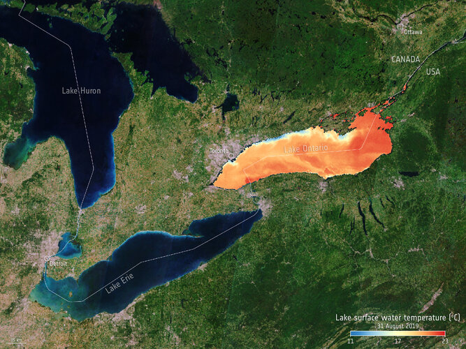
While the climate crisis is, unfortunately, a reality, it is all too easy to assume that every aspect of our changing world is a consequence of climate change. Assumptions play no role in key environmental assessments and mitigation strategies such as we will see in the upcoming UN climate change COP-26 conference – it’s the science and hard facts that are critical. New research published this week is a prime example of facts that matter. Using model projections combined with satellite data from ESA’s Climate Change Initiative, this latest research shows that the global rise in the temperature of lake water and dwindling lake-ice cover can only be explained by the increase in greenhouse gas emissions since the industrial revolution – in other words, humans are clearly to blame.
Earth from Space: New Delhi
15.10.2021 10:00
New Delhi, the capital and second-largest city of India, is featured in this image captured by the Copernicus Sentinel-2 mission.
Earth from Space: New Delhi
15.10.2021 10:00
New Delhi, the capital and second-largest city of India, is featured in this image captured by the Copernicus Sentinel-2 mission.
Working towards a Digital Twin of Earth
14.10.2021 10:45
How can a digital replica of Earth help us understand our planet’s past, present and future? As part of the fourth edition of Φ-week taking place this week, a group of European scientists have put forward their ideas on the practical implementation of Digital Twins and the potential application areas for a Digital Twin Earth in the real world.
Putting the Earth observation into ‘the market perspective’
13.10.2021 10:20
With a boom in the global market for Earth observation information and data products, participants at this year’s Φ-week conference have been digging deep into the ‘market perspective’. This important topic includes how to gain a better understanding of what governments, industry, the public and other users of Earth observation products and services need and expect to create value for society and the economy.
Putting Earth observation into ‘the market perspective’
13.10.2021 10:20
With a boom in the global market for Earth observation information and data products, participants at this year’s Φ-week conference have been digging deep into the ‘market perspective’. This important topic includes how to gain a better understanding of what governments, industry, the public and other users of Earth observation products and services need and expect to create value for society and the economy.
Watch live: Φ-week ‘Blending New Space Technologies’
12.10.2021 15:00
Watch live: Φ-week ‘Blending New Space Technologies’
ICEYE commercial satellites join the EU Copernicus programme
12.10.2021 13:10
ESA signed a contract that brings the ICEYE constellation of small satellites into the fleet of missions contributing to Europe’s Copernicus environmental monitoring programme. As a commercial provider of satellite radar imagery, ICEYE is a perfect example of European New Space being implemented within Copernicus.
Contract secures build for HydroGNSS Scout mission
11.10.2021 17:50
Today, as Φ-week gets underway, ESA has signed a contract with Surrey Satellite Technology Ltd to build the HydroGNSS Scout mission. Embracing the concept of New Space, HydroGNSS is a micro satellite that will use a technique called Global Navigation Satellite System (GNSS) reflectometry to measure climate variables such as soil moisture, freeze–thaw state over permafrost and inundation.
La Palma volcano: How satellites help us monitor eruptions
11.10.2021 15:30
Since the Cumbre Vieja volcano began erupting on 19 September 2021, lava has burned through homes, roads and farmlands causing mass destruction on the west part of the Canary Island of La Palma. Satellite imagery has helped authorities monitor and manage the ongoing crisis. From capturing images of the rivers of lava, to measuring gas emissions and assessing damage, the fleet of Copernicus Sentinel satellites have been providing crucial data for local teams.
Spotlight on climate and the New Space economy
11.10.2021 14:25
Kicking off with a bold flourish, Φ-week 2021 promises to bring space even closer to the forefront of addressing society’s biggest challenges, namely issues associated with the climate crisis, while boosting the economy through transformative New Space, artificial intelligence, and quantum and cognitive computing.
Earth from Space: Budapest, Hungary
8.10.2021 10:00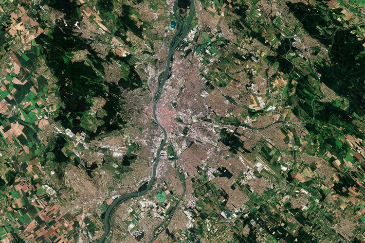
Budapest, the capital and most populous city in Hungary, is visible in this image captured by the Copernicus Sentinel-2 mission.
Father of ERS wins Nobel prize in physics
7.10.2021 16:30
The Royal Swedish Academy of Sciences has awarded a share of this year’s Nobel Prize in Physics to Klaus Hasselmann in acknowledgment of his contribution to ‘the physical modelling of Earth’s climate, quantifying variability and reliably predicting global warming’. Among Prof. Hasselmann’s long list of outstanding achievements, ESA also recognises him as one of the ‘fathers’ of ESA’s first Earth observation mission, ERS-1, which has been key to understanding our changing planet and which paved the way to modern techniques in observing Earth from space.
Watch live: ESA Φ-week
7.10.2021 16:00
Focusing on the New Space economy and innovations in Earth observation, ESA’s fourth Φ-week kicks off on Monday 11 October. Join us live for two of the main sessions: the Opening session on Monday at 10:30 CEST and the Blending New Space Technologies and Services session on Tuesday at 16:00 CEST.
First Copernicus satellite exceeds design working life
4.10.2021 16:20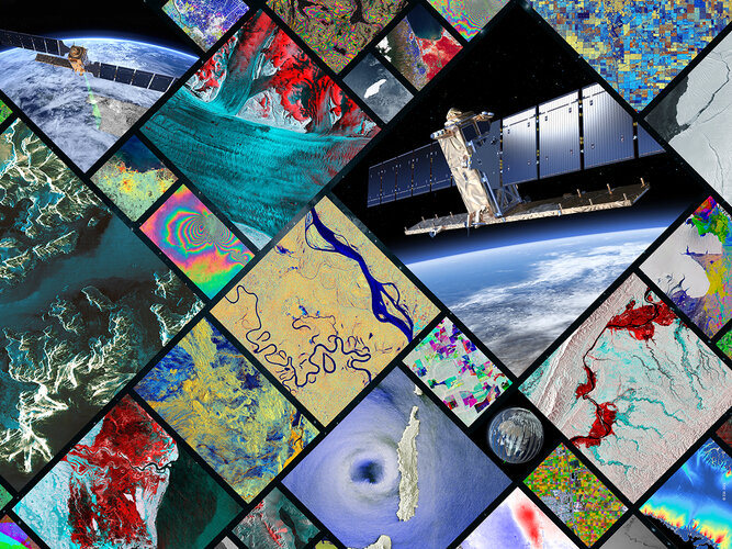
This week marks seven years since the very first satellite that ESA built for the European Union’s Copernicus programme started delivering data to monitor the environment. The Sentinel-1A satellite has shed new light on our changing world and has been key to supplying a wealth of radar imagery to aid disaster response. While this remarkable satellite may have been designed for an operational life of seven years, it is still going strong and fully expected to be in service for several years to come.
La Palma lava flows into the sea
1.10.2021 14:40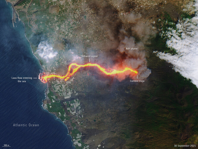 Image:
This image, captured by Copernicus Sentinel-2 on 30 September, shows the flow of lava from the volcano erupting on the Spanish island of La Palma.
Image:
This image, captured by Copernicus Sentinel-2 on 30 September, shows the flow of lava from the volcano erupting on the Spanish island of La Palma.
Earth from Space: Mackenzie River, Canada
1.10.2021 10:00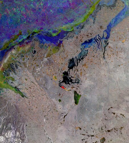
The Copernicus Sentinel-1 mission takes us over the Mackenzie River, a major river system in the Canadian boreal forest. Its basin is the largest in Canada and is the second largest drainage basin of any North American river, after the Mississippi.
Space for climate: raising awareness ahead of COP26
1.10.2021 8:40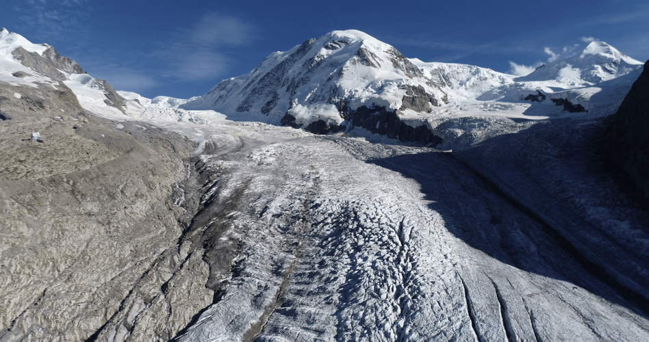
Ahead of the 26th UN Climate Change Conference of Parties (COP26), climate and energy ministers are coming together this week in Milan, Italy, to discuss the key political topics to be addressed at the upcoming global summit – taking place in early November in Glasgow.
ESA will be present at both the Pre-COP and COP26, highlighting the vital importance of observing our changing world from space and showing how satellite data play a critical role in underpinning climate policy.
Carbon dioxide released from Australian bushfires triggers algal blooms
30.9.2021 10:05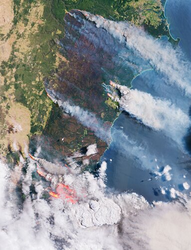
Australia’s deadly bushfires in the 2019-2020 season generated 700 million tonnes of carbon dioxide in the atmosphere – triggering vast algal blooms in the Southern Ocean. Using satellite data, two new studies published in Nature prove how satellites can illuminate the complicated ways in which Earth is responding to climate change in an era of worsening wildfires.
Aerosols released from Australian bushfires triggers algal blooms
30.9.2021 10:05
Australia’s deadly bushfires in the 2019-2020 season generated 700 million tonnes of carbon dioxide in the atmosphere – triggering vast algal blooms in the Southern Ocean. Using satellite data, two new studies published in Nature prove how satellites can illuminate the complicated ways in which Earth is responding to climate change in an era of worsening wildfires.
Space for our Planet: Space Solutions for a Sustainable World
28.9.2021 12:00
At ESA, we believe that we have a responsibility to use our space technologies, applications and services to benefit planet Earth and humankind. Some examples of how we do this are now on display in Paris and Brussels at a new exhibition called Space for our Planet: Space Solutions for a Sustainable World.
Going hyperspectral for CHIME
27.9.2021 9:15
With Covid restrictions a little more relaxed, scientists from Europe and the USA were finally able to team up for a long-awaited field experiment to ensure that a new Copernicus satellite called CHIME will deliver the best possible data products as soon as it is operational in orbit. This new mission is being developed to support EU policies on the management of natural resources, ultimately helping to address the global issue of food security.
Wildfire Map wins top prize at App Camp
24.9.2021 14:30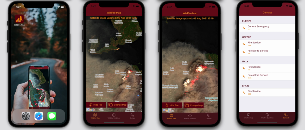
An app that uses satellite data to show the location and impact of wildfires took home the top prize at this year’s Space App Camp.
Earth from Space: Calabria, Italy
24.9.2021 10:00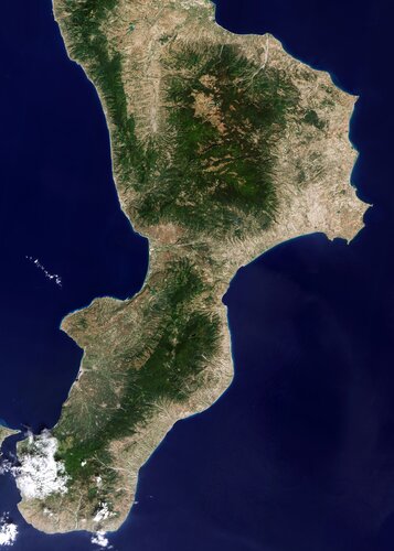
Calabria, often referred to as the ‘boot’ of Italy, is featured in this image captured by the Copernicus Sentinel-2 mission.
Joining forces for Aeolus
20.9.2021 9:00
For a team of scientists and technicians from Europe and the US, the fact of ‘going back to the office’ this September has meant heading off to the Cabo Verde islands in the Atlantic – not to extend their summer holidays, but for a complex international experiment campaign that will scrutinise the data being delivered by one of today’s most innovative Earth observation satellites: ESA’s Aeolus wind mission.
Earth from Space: Maharloo Lake
17.9.2021 10:00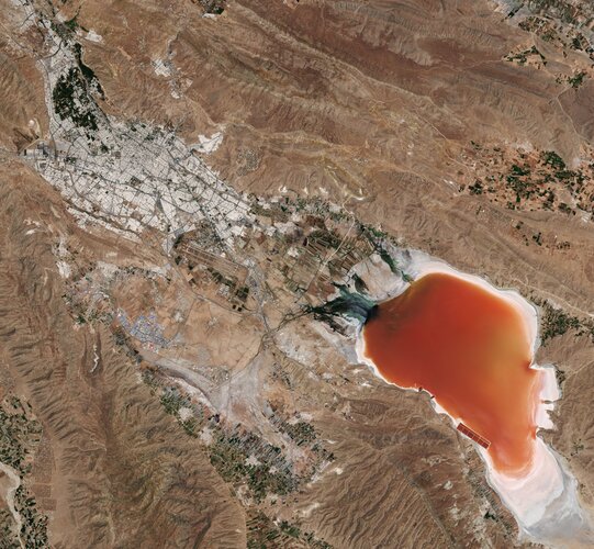
Maharloo Lake, a seasonal salt lake in Iran, is featured in this image captured by the Copernicus Sentinel-2 mission.
What’s going on with the ozone?
16.9.2021 13:10
World governments agreed in the late 1980s to protect Earth’s ozone layer by phasing out ozone-depleting substances emitted by human activities, under the Montreal Protocol. The phase out of these substances has not only helped protect the ozone layer for future generations but has also protected human health and ecosystems by limiting the harmful ultraviolet radiation from reaching Earth. On 16 September, the International Day for the Preservation of the Ozone Layer, we take a closer look at this year’s ozone hole.
What’s going on with the ozone?
16.9.2021 13:10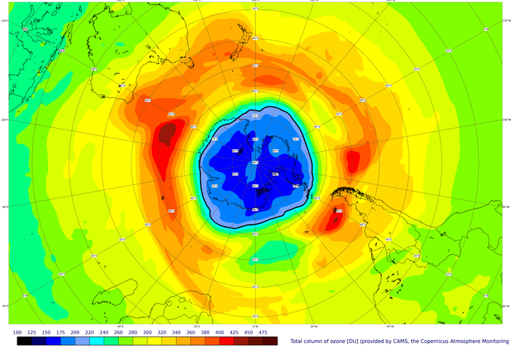
World governments agreed in the late 1980s to protect Earth’s ozone layer by phasing out ozone-depleting substances emitted by human activities, under the Montreal Protocol. The phase out of these substances has not only helped protect the ozone layer for future generations but has also protected human health and ecosystems by limiting the harmful ultraviolet radiation from reaching Earth. On 16 September, the International Day for the Preservation of the Ozone Layer, we take a closer look at this year’s ozone hole.
California continues to burn
15.9.2021 18:00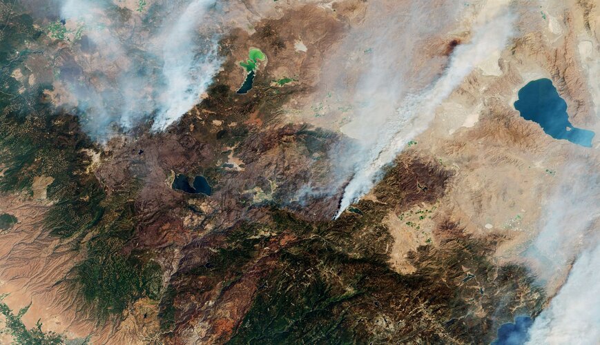
While wildfires are a natural part of California’s landscape, a severe drought, coupled with extreme temperatures, have sustained several major fires for much of August. As of 14 September, more than 7000 wildfires have been recorded, burning over 900 000 hectares across the state.
Announcing Earth observation hackathon winners
14.9.2021 10:00
In June 2021, more than 4300 participants from 132 countries and territories came together to solve challenges related to the COVID-19 pandemic. ESA, NASA and the Japan Aerospace Exploration Agency (JAXA) are pleased to announce CleverChart and TRACER as the winners of the Open Science Award.
Earth from Space: Danube Delta
10.9.2021 10:00
The Copernicus Sentinel-2 mission takes us over the Danube Delta – the second largest river delta in Europe.
Earth from Space: Danube Delta
10.9.2021 10:00
The Copernicus Sentinel-2 mission takes us over the Danube Delta – the second largest river delta in Europe.
Meteosat Third Generation takes major step towards its first launch
2.9.2021 9:30
After many technical and programmatic challenges, the first satellite of the next generation of the Meteosat family has taken a major step towards its first flight, currently scheduled for launch in autumn 2022.
Satellite data provide valuable support for IPCC climate report
31.8.2021 11:25
Earlier this month, the Intergovernmental Panel on Climate Change (IPCC) published its latest assessment report laying out the accumulating evidence of the climate crisis. The report identifies Earth observing satellites as a critical tool to monitor the causes and effects of climate change and directly acknowledges the contribution of ESA’s Climate Change Initiative – a research programme that draws on observations from multiple satellite missions.
ESA astronaut joins glacier expedition in Alps
23.8.2021 15:30
From space, the synchronous retreat of the world’s glaciers can be clearly observed. To get a first-hand view of these changes, ESA astronaut Luca Parmitano, along with Susanne Mecklenburg, Head of ESA’s Climate Office, have joined a science expedition taking place at one of the biggest ice masses in the Alps: the Gorner Glacier.
A-74 iceberg near collision with Brunt Ice Shelf
20.8.2021 12:15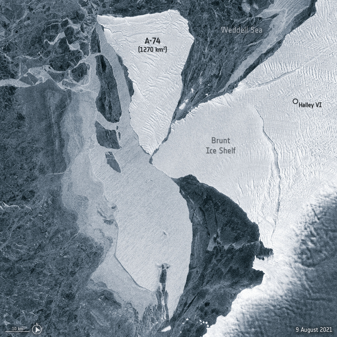 Image:
New radar images show the A-74 iceberg spinning around the western tip of the Brunt Ice Shelf, brushing slightly against it before continuing southwards.
Image:
New radar images show the A-74 iceberg spinning around the western tip of the Brunt Ice Shelf, brushing slightly against it before continuing southwards.
Wildfires ravage Greek island of Evia
12.8.2021 15:15 Image:
Parts of the Mediterranean and central Europe have experienced extreme temperatures this summer, with wildfires causing devastation on the Greek island of Evia. This Copernicus Sentinel-2 image shows the extent of the burned area in the northern part of the island.
Image:
Parts of the Mediterranean and central Europe have experienced extreme temperatures this summer, with wildfires causing devastation on the Greek island of Evia. This Copernicus Sentinel-2 image shows the extent of the burned area in the northern part of the island.
Living Planet Symposium 2022: Call for proposals
10.8.2021 9:40
ESA is now accepting proposals for sessions at the next Living Planet Symposium – set to take place on 23–27 May 2022 at the World Conference Center in Bonn, Germany.
Gearing up for third Sentinel-2 satellite
9.8.2021 8:40
With the first Copernicus Sentinel-2 satellite in orbit since 2015 and the second since 2017, engineers are busy preparing the mission’s follow-on pair to eventually pick up the baton to supply images for a myriad of applications from food security to monitoring the decline of Earth’s ice. Slated for launch at the beginning of 2024, Sentinel-2C has just started a punishing five-month testing programme to ensure that it is fit for its life in space.
Satellites reveal how forests increase cloud and cool climate
5.8.2021 10:45
Forests are not only key to moderating our climate by sequestering atmospheric carbon, but they also create a cooling effect by increasing low-level cloud. A first global assessment using satellite observations has shown that for two-thirds of the world, afforestation increases low-level cloud cover, with the effect being strongest over evergreen needleleaf forest.
Russia’s forests store more carbon than previously thought
4.8.2021 9:20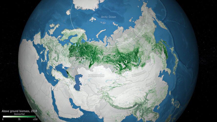
Russia has the largest area of forest on the planet, with more than a fifth of the world's trees. A new study, led by Russian scientists using data from ESA’s Climate Change Initiative, has produced new estimates of biomass contained in Russian forests, and confirms that the vast forested area is storing more carbon than previously estimated.
Mediterranean continues to bake
3.8.2021 16:11 Image:
This map generated using data from Copernicus Sentinel-3 shows the temperature of the land surface on 2 August 2021.
Image:
This map generated using data from Copernicus Sentinel-3 shows the temperature of the land surface on 2 August 2021.
Smoke billows from fires in Turkey
2.8.2021 16:43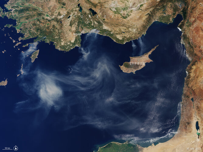 Image:
Captured by the Copernicus Sentinel-3 mission on 30 July 2021, this image shows smoke billowing from several fires along the southern coast of Turkey.
Image:
Captured by the Copernicus Sentinel-3 mission on 30 July 2021, this image shows smoke billowing from several fires along the southern coast of Turkey.
Accounting for Earth’s water cycle
2.8.2021 9:30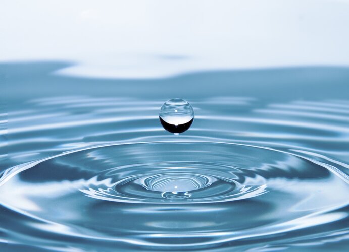
The amount of water on Earth is finite. Sustaining life, this precious resource has been circulating between Earth’s surface and atmosphere for over four billion years, and changing between a liquid, a solid and a gas along the way. Although the total amount of water within the cycle remains constant, the way it is split between its various reservoirs changes continually. With the climate crisis leading to more extreme droughts and floods, the availability of enough freshwater where we need it is a growing concern. How can we be sure that we are using our water resources sustainably?
Earth from Space: Malé, the Maldives
30.7.2021 10:00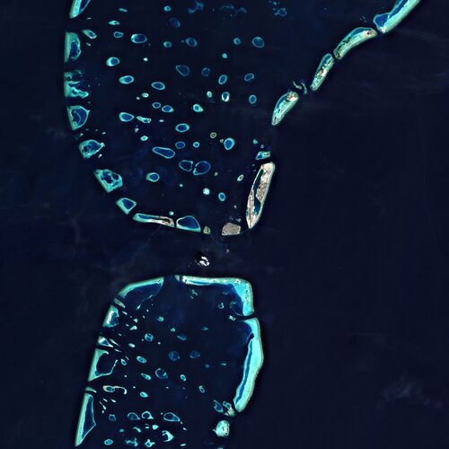
The Copernicus Sentinel-2 mission takes us over Malé – the capital and most populous city in the Republic of Maldives.
Earth from Space: Malé, the Maldives
30.7.2021 10:00
The Copernicus Sentinel-2 mission takes us over Malé – the capital and most populous city in the Republic of Maldives.
Earth from Space: Tarso Toussidé, Chad
23.7.2021 10:00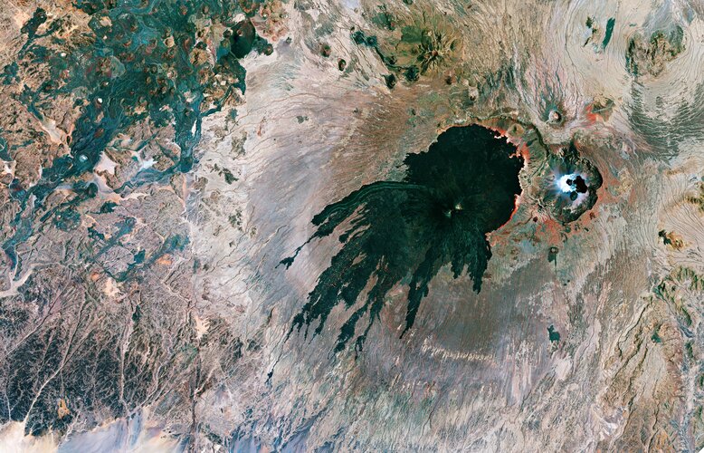
The Tarso Toussidé volcanic massif is featured in this false-colour composite image captured by the Copernicus Sentinel-2 mission.
Earth from Space: Tarso Toussidé, Chad
23.7.2021 10:00
The Tarso Toussidé volcanic massif is featured in this false-colour composite image captured by the Copernicus Sentinel-2 mission.
Counting carbon
22.7.2021 14:00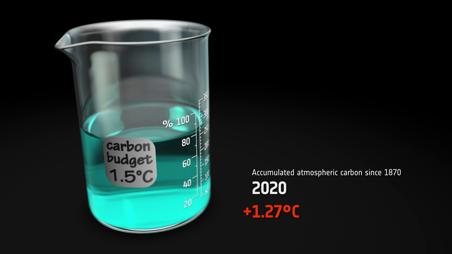 Video:
00:03:40
Video:
00:03:40
The Paris Agreement adopted a target for global warming not to exceed 1.5°C. This sets a limit on the additional carbon we can add to the atmosphere – the carbon budget. Only around 17% of the carbon budget is now left. That is about 10 years at current emission rates.
Each country reports its annual greenhouse gas emissions to the United Nations. Scientists then set these emissions against estimates of the carbon absorbed by Earth’s natural carbon sinks. This is known as the bottom-up approach to calculating the carbon budget.
Another way to track carbon sources and sinks is to measure the amounts of greenhouse gases in the atmosphere from space – the top-down approach. As well as tracking atmospheric carbon, ESA’s Climate Change Initiative is using satellite observations to track other carbon stocks on land and sea.
How we use the land accounts for about a quarter of our greenhouse gas emissions. Forests are the largest store of carbon on the land. Fire acts as a conduit for carbon to pass from the land to the atmosphere. And phytoplankton in the ocean are an important carbon sink.
ESA’s Regional Carbon Cycle Analysis and Processes project is using this information to reconcile the differences between the bottom-up and top-down approaches. Observations are combined with atmospheric and biophysical computer models to deduce carbon fluxes at the surface. This will improve the precision of each greenhouse gas budget and help separate natural fluxes from agricultural and fossil fuel emissions. This work will help us gauge whether we can stay within the 1.5°C carbon budget, or if more warming is in store.
Satellites map floods in western Europe
16.7.2021 16:00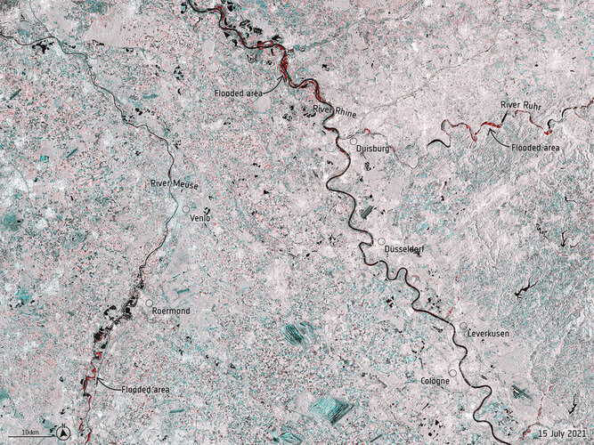 Image:
Record rainfall has caused swollen rivers to burst their banks and wash away homes and other buildings in western Europe. Data from the Copernicus Sentinel-1 mission are being used to map flooded areas to help relief efforts.
Image:
Record rainfall has caused swollen rivers to burst their banks and wash away homes and other buildings in western Europe. Data from the Copernicus Sentinel-1 mission are being used to map flooded areas to help relief efforts.
ERS: 30 years of outstanding achievements
16.7.2021 11:30
ESA’s first Earth observation mission dedicated to understanding our planet, the European Remote Sensing satellite (ERS-1), was launched into orbit on 17 July 1991 – almost 30 years ago today. At the time of its launch, the ERS satellite was one of the most sophisticated spacecraft ever developed and launched by Europe, paving the way for satellite technology in the areas of atmosphere, land, ocean and ice monitoring. Today, we look back at some of the mission’s key accomplishments.
Earth from Space: Lima, Peru
16.7.2021 10:00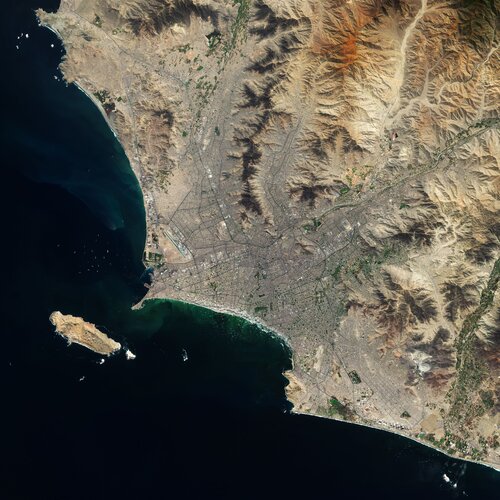
Lima, the capital and largest city of Peru, is featured in this Copernicus Sentinel-2 image.
Earth from Space: Lima, Peru
16.7.2021 10:00
Lima, the capital and largest city of Peru, is featured in this Copernicus Sentinel-2 image.
ERS-1: the first image
15.7.2021 10:00 Video:
00:23:29
Video:
00:23:29
ESA’s first Earth observation mission dedicated to understanding our planet, the European Remote Sensing satellite (ERS-1), was launched into orbit on 17 July 1991. At the time, it was the most sophisticated Earth observation spacecraft developed and launched by Europe.
Thirty years ago, as the team went through the launch and early-orbit phase, the first synthetic aperture radar images were awaited in Kiruna and Fucino. Featuring video footage taken in 1991, the team involved tells the story of the anxious moments and important breakthroughs they made as the first images arrived.
Features interviews with:
Stephen Coulson, Former Earth Observation Applications Engineer
Mark Doherty, Former Head of ERS Product Control Service
Henri Laur Former Head of Processing of ERS-1 SAR data
ERS-1 first image: solving the mystery
15.7.2021 10:00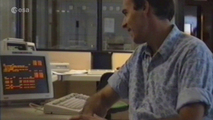 Video:
00:23:29
Video:
00:23:29
ESA’s first Earth observation mission dedicated to understanding our planet, the European Remote Sensing satellite (ERS-1), was launched into orbit on 17 July 1991. At the time, it was the most sophisticated Earth observation spacecraft developed and launched by Europe.
Thirty years ago, as the team went through the launch and early-orbit phase, the first synthetic aperture radar images were awaited in Kiruna and Fucino. Featuring video footage taken in 1991, the team involved tells the story of the anxious moments and important breakthroughs they made as the first images arrived. Get an insider view into the problem-solving moments from inside one of ESA's processing rooms.
Features interviews with:
Stephen Coulson, Former Earth Observation Applications Engineer
Mark Doherty, Former Head of ERS Product Control Service
Henri Laur, Former Head of Processing of ERS-1 SAR data
ERS-1: the first image
15.7.2021 10:00
Video:
00:23:29
ESA’s first Earth observation mission dedicated to understanding our planet, the European Remote Sensing satellite (ERS-1), was launched into orbit on 17 July 1991. At the time, it was the most sophisticated Earth observation spacecraft developed and launched by Europe.
Thirty years ago, as the team went through the launch and early-orbit phase, the first synthetic aperture radar images were awaited in Kiruna and Fucino. Featuring video footage taken in 1991, the team involved tells the story of the anxious moments and important breakthroughs they made as the first images arrived.
Features interviews with:
Stephen Coulson, Former Earth Observation Applications Engineer
Mark Doherty, Former Head of ERS Product Control Service
Henri Laur Former Head of Processing of ERS-1 SAR data
ERS-1 first image: solving the mystery
15.7.2021 10:00
Video:
00:23:29
ESA’s first Earth observation mission dedicated to understanding our planet, the European Remote Sensing satellite (ERS-1), was launched into orbit on 17 July 1991. At the time, it was the most sophisticated Earth observation spacecraft developed and launched by Europe.
Thirty years ago, as the team went through the launch and early-orbit phase, the first synthetic aperture radar images were awaited in Kiruna and Fucino. Featuring video footage taken in 1991, the team involved tells the story of the anxious moments and important breakthroughs they made as the first images arrived. Get an insider view into the problem-solving moments from inside one of ESA's processing rooms.
Features interviews with:
Stephen Coulson, Former Earth Observation Applications Engineer
Mark Doherty, Former Head of ERS Product Control Service
Henri Laur Former Head of Processing of ERS-1 SAR data
ESA and NASA join forces to understand climate change
13.7.2021 19:00
Climate change is, arguably, the biggest environmental challenge the global population faces today. To address this major issue, decision-makers not only need accurate information on how our world is changing now, but also predictions on what may happen in the future. A sound knowledge of how Earth behaves as one system is the foundation to all of this – and the pieces of this complex puzzle come largely from satellites orbiting our planet. To ensure that data from Earth-observing satellites are used to their best advantage, further science and, ultimately, bring the most benefit to humankind, ESA and NASA have formed a strategic partnership for Earth science and climate change.
Swarm yields new insight into animal migration
9.7.2021 14:40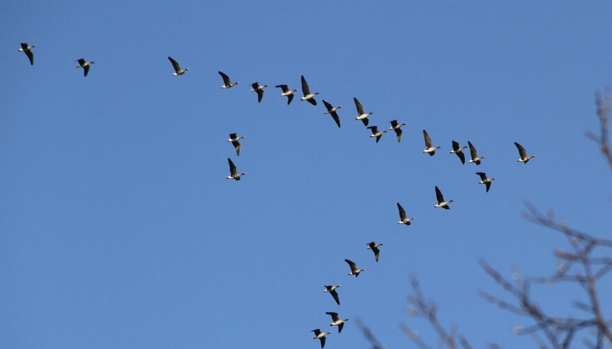
Using measurements from ESA’s Earth Explorer Swarm mission, scientists have developed a new tool that links the strength and direction of the magnetic field to the flight paths of migrating birds. This is a huge step forward to understanding how animals use Earth’s magnetic field to navigate vast distances.
Earth from Space: Gulf of Martaban
9.7.2021 10:00
The Gulf of Martaban, an arm of the Andaman Sea located in southern Myanmar, is featured in this false-colour image captured by the Copernicus Sentinel-2 mission.
Earth from Space: Gulf of Martaban
9.7.2021 10:00
The Gulf of Martaban, an arm of the Andaman Sea located in southern Myanmar, is featured in this false-colour image captured by the Copernicus Sentinel-2 mission.
 Image:
A touch of sun
Image:
A touch of sun
New satellite data techniques reveal coastal sea-level rise
7.7.2021 12:15
For the hundreds of millions of people living in coastal regions around the world, rising seas driven by climate change pose a direct threat. In order for authorities to plan appropriate protection strategies, accurate information on sea-level rise close to the coast is imperative. For various reasons, these measurements are difficult to get from satellites. However, new ESA-funded research demonstrates how a specific way of processing satellite altimetry data now makes it possible to determine sea-level change in coastal areas with millimetre per year accuracy, and even if the sea is covered by ice.
Earth from Space: North Frisian Islands
2.7.2021 10:00
Part of the Frisian Islands, a low-lying archipelago just off the coast of northern Europe, is visible in this image captured by the Copernicus Sentinel-2 mission.
Earth from Space: North Frisian Islands
2.7.2021 10:00
Part of the Frisian Islands, a low-lying archipelago just off the coast of northern Europe, is visible in this image captured by the Copernicus Sentinel-2 mission.
Canada–US heatwave
1.7.2021 16:49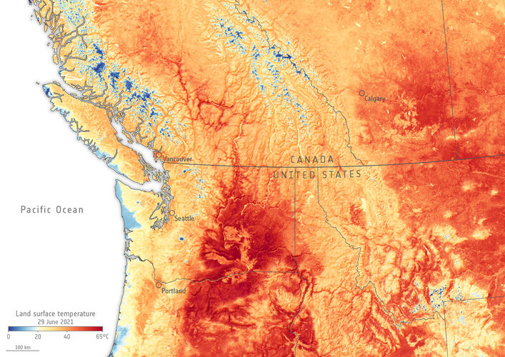 Image:
The heatwave now hitting parts of western Canada and the US has been particularly devastating. This Copernicus Sentinel-3 image shows land surface temperature.
Image:
The heatwave now hitting parts of western Canada and the US has been particularly devastating. This Copernicus Sentinel-3 image shows land surface temperature.
Shoemaker Crater, Australia
30.6.2021 10:30 Image:
For Asteroid Day, the Copernicus Sentinel-2 mission takes us over the Shoemaker Impact Structure (formerly known as Teague Ring) in Western Australia.
Image:
For Asteroid Day, the Copernicus Sentinel-2 mission takes us over the Shoemaker Impact Structure (formerly known as Teague Ring) in Western Australia.
Earth from Space: Lake Mar Chiquita
25.6.2021 10:00
The Copernicus Sentinel-1 mission takes us over Lake Mar Chiquita – an endorheic salt lake in the northeast province of Córdoba, Argentina.
ESA and EU celebrate a fresh start for space in Europe
22.6.2021 10:15Press Release N° 20–2021
After months of constructive negotiations, ESA and EU signed today a new Financial Framework Partnership Agreement (FFPA) in a ceremony to celebrate the launch of the new EU space programme.
New sea-level monitoring satellite goes live
21.6.2021 16:30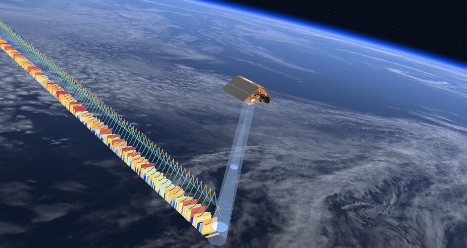
Following liftoff last November and more than six months spent carefully calibrating the most advanced mission dedicated to measuring sea-level rise, Copernicus Sentinel-6 Michael Freilich is now operational – meaning that its data are available to climate researchers, ocean-weather forecasts and other data users.
Stark reality of Californian drought from space
21.6.2021 10:30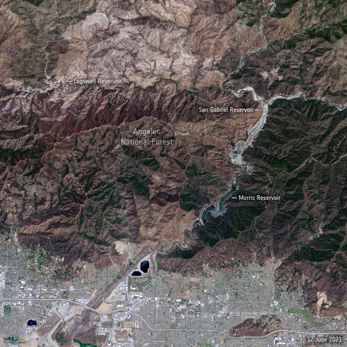 Image:
Stark reality of Californian drought from space
Image:
Stark reality of Californian drought from space
Take part in ESA’s Space App Camp
21.6.2021 9:20
ESA is inviting up to 25 committed mobile app developers and specialists in artificial and machine learning related to observing Earth from space to join this year’s Space App Camp, which will be a virtual event over eight weeks, from 20 July to 20 September.
Earth from Space: Tana River
18.6.2021 10:00
The Tana River, Kenya’s longest river, is featured in this false-colour image captured by the Copernicus Sentinel-2 mission.
Earth from Space: Tana River
18.6.2021 10:00
The Tana River, Kenya’s longest river, is featured in this false-colour image captured by the Copernicus Sentinel-2 mission.

Satellites reveal cause of Chamoli disaster
14.6.2021 11:30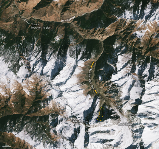
A new study using satellite evidence confirms that a rock and ice avalanche caused the Chamoli disaster in India earlier this year. The resulting mud and debris flood led to massive destruction downstream.
Earth from Space: Chongqing, China
11.6.2021 10:00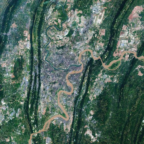
Chongqing, the largest municipality in China, is featured in this Copernicus Sentinel-2 image.
Earth from Space: Chongqing, China
11.6.2021 10:00
Chongqing, the largest municipality in China, is featured in this Copernicus Sentinel-2 image.
Four mission ideas to compete for Earth Explorer 11
10.6.2021 12:20
As part of ESA’s commitment to develop and build satellite missions that push the boundaries of satellite technology and Earth science, four new mission ideas – Cairt, Nitrosat, Seastar and Wivern – have been selected to enter pre-feasibility study and compete to be the eleventh Earth Explorer mission.
Forest degradation primary driver of carbon loss in the Brazilian Amazon
10.6.2021 11:00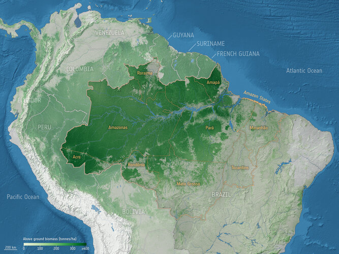
Forest degradation has become the largest process driving carbon loss in the Brazilian Amazon, according to a recent study using ESA satellite data.
Arctic coastal sea ice thinning twice as fast than thought
10.6.2021 9:10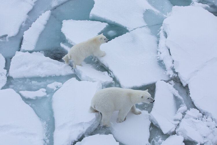
Research based on ice-thickness data from ESA’s CryoSat and Envisat missions along with a new model of snow has revealed that sea ice in the coastal regions of the Arctic may be thinning twice as fast as thought.